Forests store more carbon than any other above-ground ecosystem on the planet. Just how much, though, is hard to know without cutting them down. Enter ‘virtual harvesting’, a non-destructive remote sensing technique for accurately measuring biomass that has just been undertaken at TERN’s tropical forest observing sites.
Tracking Australia’s, and indeed the international community’s, progress towards meeting major global environmental agreements and targets, such as the Sustainable Development Goals (SDGs) and The Paris Agreement, requires detailed accounts of carbon stocks and how they’re changing over time.
“We know that forest ecosystems contain more carbon biomass than any other above-ground ecosystem on the planet,” says Dr Kim Calders of Belgium’s Ghent University.
It’s estimated that Australian forests store about 10 billion tonnes of carbon, but calculating an exact figure without cutting down trees is difficult.
What 12 tons of a single tree trunk looks like when cut into beer mats. Amazing work by the team in Caxiuanã @UCLgeography @NCEOscience @BoniVicari pic.twitter.com/Y6UZFi9F5h
— Mathias Disney (@mathiasdisney) October 4, 2018
“Traditional methods of estimating aboveground biomass are based on volumes calculated from cut trees and expensive field measurements of tree diameter and height.”
Kim and his colleague Prof. Hans Verbeeck lead the ambitious ‘3D-FOREST’ project that aims to overcome such challenges by developing novel on-ground remote sensing techniques to measure biomass and forest structure and validate global-scale satellite measurements.
Lasers and drones create virtual forests at TERN sites
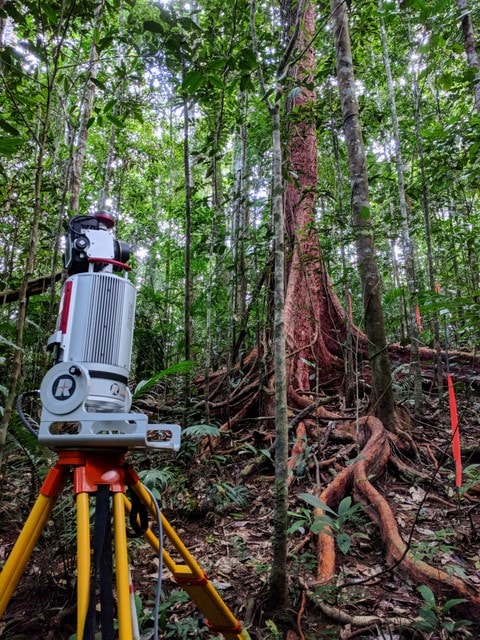
To collect vital southern hemisphere biomass data for the project, the 3D-FOREST team and their Australian government and university partners recently conducted surveys at three TERN tropical forest bioacoustics research sites in Queensland and the Northern Territory. The team used a combination of on-ground and airborne LiDAR to quantify aboveground biomass and forest structure
“The concept of the project is to capture data to create ‘virtual forests’ with high-level detail,” says Kim. “The combination of ‘bottom-up’ terrestrial laser scanning (TLS) and ‘top-down’ UAV LiDAR data improves biomass estimates and knowledge on how we can upscale plot-based measurements to the landscape level.”
“Tropical forests are challenging sites to survey with UAV as we require a canopy gap for take-off and landing, as well as line-of-sight during the entire flight.”
“TERN sites offered great infrastructure such as canopy towers or canopy cranes to successfully survey using UAV methods.”
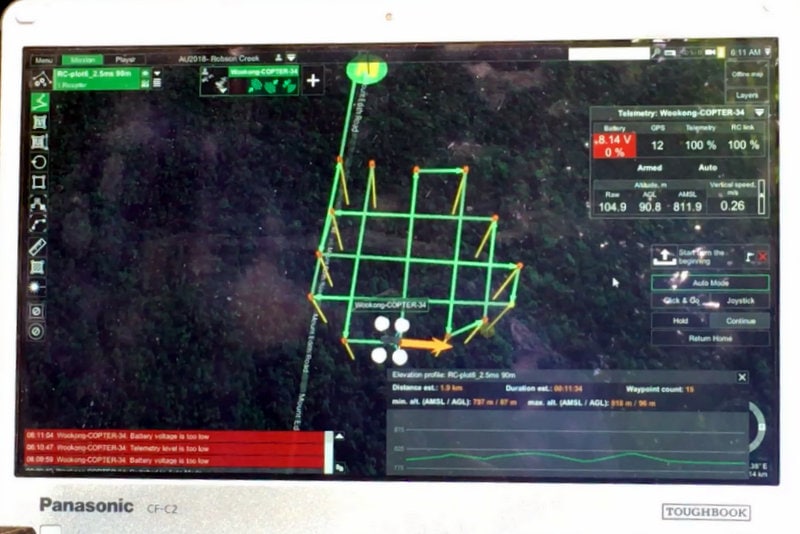
Airborne UAV LiDAR scanning at TERN Robson Creek SuperSite from TERN Australia on Vimeo.
UAV LiDAR data were collected at TERN sites using the state-of-the-art RIEGL RiCOPTER operated by Dr. Harm Bartholomeus from the Netherlands’ Wageningen University, with eddy covariance flux towers providing the necessary infrastructure to successfully survey dense tropical forests using UAV methods (Imagery courtesy of Mirko Karan)
Harvesting virtual forests for traceable carbon estimates
Back in the lab, virtual 3D forests created from the LiDAR data collected in the field are then ‘virtually harvested’. Quantitative structure models (QSM) digitally weigh individual trees by calculating their volume and converting this to carbon mass.
“These 3D structural metrics and biomass estimates allow us to scale-up the spatial patterns of tree structure and evenness from the 1ha plot scale to entire forests,” says Kim.
“This information is crucial for more efficient forest management, but also for better understanding of the spatial variation of forest structure in ecosystem models.”
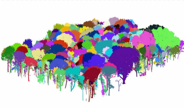
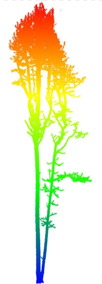
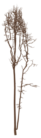
Virtual 3D forests created from LiDAR data collected in the field (left and centre) are ‘virtually harvested’ to calculate individual tree biomass (right) (images courtesy of Kim Calders)
Scaling up from forests to global carbon budgets
As Europe’s, America’s and India’s space agencies get ready to launch satellites to measure and map the planet’s forests in high-resolution 3D, the value of on-ground and UAV LiDAR data collected by Kim’s team at TERN sites is even more apparent.
The data from 3D-FOREST will be used to calibrate, validate and improve the accuracy of global bio-geophysical satellite data delivered by space missions including the European Space Agency’s BIOMASS, NASA’s GEDI, and the joint Indian Space Research Organisation and NASA NISAR.
“The ability for these space missions to scale-up estimates of forest biomass to the global carbon budget and monitor ecosystem disturbances, is dependent on the high-quality ground reference measurements collected at ecosystem research infrastructure sites, including TERN’s,” Kim says.
“The emerging methods and technologies for data collection, and the speed of their development, are truly exciting.”
- 3D-FOREST is a three-year project funded by the Belgian Federal Science Policy Office and led by Dr Kim Calders and Prof Hans Verbeeck from Ghent University, partnering with Dr Harm Bartholomeus and Prof Martin Herold from Wageningen University.
- Representatives of the 3D-FOREST team undertook terrestrial laser scanning and UAV LiDAR data collection at the TERN Litchfield Savanna SuperSite in the Northern Territory; the TERN Robson Creek SuperSite and the affiliate TERN Daintree Rainforest SuperSite in Queensland. The field campaign was made possible thanks to collaborations with the CSIRO, James Cook University and the Australian Government Department of Environment and Energy.
- For more information on the TERN Ecosystem Processes platform, its network of 12 open-access SuperSites and eddy covariance flux towers, and the data they collect click here or explore the open data via TERN’s Data Discovery Portal.
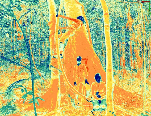
The 3D-FOREST team, including Kim Calders, Louise Terryn and Barbara D’Hont (right) completed terrestrial laser scanning at three TERN ecosystem observation sites including at TERN’s Robson Creek Rainforest SuperSite (left and right)
Fieldwork successfully finished after more than 2 months in tropical Australia! The @wurcgi @RIEGL #RiCOPTER enjoyed its stay Down Under! pic.twitter.com/oCkmGobt8O
— Kim Calders (@kimcalders) September 20, 2018
Successful day of flying LiDAR and hyperspectral at @TERN_Aus @LitchfieldSSS. First RiCOPTER flights in Australia with @wurcgi and @CAVElab_UGent. Many thanks to @shaunlevick @ReneeBartolo @RIEGL @belspo! pic.twitter.com/0STSIwMPCG
— Kim Calders (@kimcalders) September 12, 2018
In the past month we scanned from 583 locations in 20 scan days covering five plots and 4.5 ha of tropical Australian ecosystems. Revisiting all those sites with LiDAR and hyperspectral drones in September with @ReneeBartolo @WUR @CAVElab_UGent @belspo @TERN_Aus @RIEGL! pic.twitter.com/iNcy3hlsCt
— Kim Calders (@kimcalders) August 23, 2018
After five days of driving we have arrived in @TERN_Aus @LitchfieldSSS for our final days of TLS work with @shaunlevick. pic.twitter.com/Poj8uCF7q0
— Kim Calders (@kimcalders) August 21, 2018
