TERN’s online ‘Geo-Wiki’ tool crowdsources the on-ground observations and local knowledge of volunteers to help validate and improve map products derived from satellite imagery. Thanks to a recently developed tutorial accompanying the Geo-Wiki, a number of leading universities nationwide are now using this interactive piece of TERN environmental monitoring systems infrastructure to support their remote sensing courses.
The Geo-Wiki allows people to view ecosystem map products delivered by TERN AusCover online, with Google Earth as a backdrop. Users can then compare the TERN maps with Google Earth, and add their own local knowledge of an area, to determine if the TERN map product is displaying correct attributes for that area. If the information is incorrect, users can submit photos and information to improve the map. The Geo-Wiki system then alerts TERN AusCover staff who use the submitted information to validate and improve the map product.
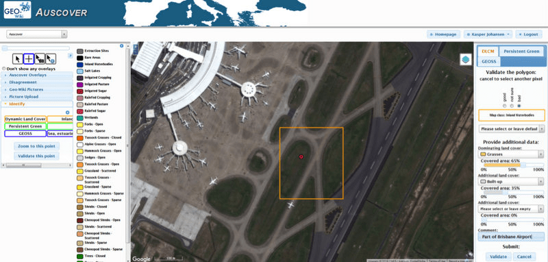
The TERN AusCover Geo-Wiki is used to improve TERN map products—in this case, the validation of pixel classified as “Inland Waterbodies”
The new TERN Geo-Wiki tutorial enables students to become familiar with what a final map product looks like, why accuracy assessments are important, and how validation can be undertaken for large area mapping. It has already been used in undergraduate and postgraduate classes at the University of Queensland, University of Adelaide, and University of Technology Sydney (UTS).
Prof Alfredo Huete uses the Geo-Wiki tutorial in classes at UTS and says ‘It’s a great exercise and the students were very excited to be able to locate areas they know well like Sydney suburbs and parks, and to see the crudeness of some ‘coarse scale’ land cover products.’
‘They now have a deeper knowledge of what is required to develop and validate remotely sensed map products, and are better equipped to undertake this work.’
By using the TERN Geo-Wiki, students can be directly involved in improving important map products for Australia, and also get a link to the researchers undertaking this work. The exchange of questions and information enabled by the Geo-Wiki is simultaneously improving outcomes for researchers and students, and ultimately delivers better remotely sensed environmental information for Australia – a win for everyone!
- If you have any questions or would like to use the TERN AusCover Geo-Wiki tool, please contact TERN AusCover’s Kasper Johansen.
Published in TERN newsletter July 2016
