This edition we’re featuring the Australian National University’s Centre for Water and Landscape Dynamics and their work combining satellite observations, field data and prediction models to measure, monitor, and forecast the world around us, including bushfires and drought.
The Centre for Water and Landscape Dynamics (WALD) aims to be a world leader in observation technology for real-time environmental information, says centre director Professor Albert van Dijk.
“Our team develops new methods to measure, monitor and forecast climate, water availability and landscape conditions. We develop spatial solutions for managing water resources, coping with extreme events, decision-making in agriculture and forestry.
“Often, that means combining Big Data from satellite observation and sensor networks with field research, biophysical modelling and machine learning, for example.
“We try to balance developing practical solutions for today’s challenges based on today’s science and technology, and at the same time pursuing the new discoveries that will help us in future.”
Prof Albert van Dijk, WALD ANU
Tools for better bushfire preparedness
One of WALD’s priority areas is bushfire research and, in particular, developing tools and techniques that better predict fire risk and impacts on the natural environment.
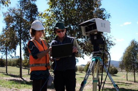
Led by Dr Marta Yebra, WALD researchers investigate new methods for estimating fuel load and flammability from proximal, airborne and satellite-based sensors, developing automated algorithms to map burn severity from satellite imagery, and combining satellite data with models to predict fire impacts on natural resources.
Dr Yebra developed Australia’s first Australian Flammability Monitoring System for the Bushfire and Natural Hazards Cooperative Research Centre (BNHCRC). This unique online system uses satellite data to calculate the current moisture content of Australia’s grasslands, shrublands and forests and their flammability.
“If we know how dry a fire’s potential fuel source is, we can estimate how likely it is that the fuel will be ignited and how rapidly the fire will grow.
“We’ve created an accurate satellite-based technology specifically for the Australian landscape by incorporating the unique properties of eucalypt forests that occur across much of the country.”
Dr Marta Yebra, ANU WALD
The information can be used to plan hazard reduction burns but can also help respond to bushfire events. During the current ‘Black Summer’, Dr Yebra has been working closely with fire managers from the New South Wales Rural Fire Service (RFS) to analyse data on vegetation conditions and how this might affect bushfire spread.
“Our research is being used to understand the dryness of the vegetation, to predict where and how fast a fire may spread, and what areas should be prioritised when sending resources and equipment.”
Dr Marta Yebra, ANU WALD
Of droughts and flooding rains
Two other priority research areas at WALD are in are the use of satellite observations to generate improved soil water information products for drought monitoring applications, and to enhance real-time rainfall prediction and nowcasting capability.
Dr Luigi Renzullo and other WALD researchers have been working with Bureau of Meteorology, TERN and others to assimilate satellite soil moisture products into landscape water balance models to improve root-zone soil moisture estimation across Australia. Current research publications are developing ways to achieve unparalleled spatial detail in real-time monitoring and forecasts over large areas, down to a few tens of meters.
In addition to this soil moisture work, Dr Renzullo leads research to prototype real-time rainfall information and nowcasts system by merging data from different sources, funded by the government of India. The project brings together researchers from WALD, the Bureau of Meteorology and India’s National Centre for Medium Range Weather Forecasting.
“Real-time rainfall information, telling us the amount and extent rainfall that occurred just a few minutes ago, provides a much-needed heads-up to emergency services and the public in general.
“By merging multiple sources of rainfall data, including satellites weather radar and model forecasts, we often do better than any single data source alone. That can help warn for and protect us from severe weather and its impacts, such as flash flooding.”
Dr Luigi Renzullo, WALD ANU
With funding from the European Union’s Copernicus program, WALD is extending the multi-source rainfall merging techniques to a service that will provide recent weather data at 1 kilometre resolution for the globe.

Annual reporting on Australia’s environment
Prof van Dijk emphasises that an important aspect of WALD is its close working relationships with “those that matter most – those that have to make a decision”.
“We collaborate closely with fire managers, for example, and those that manage national parks, defence lands and agricultural landscapes.
“Working with the Bureau of Meteorology, we can reach land and water managers, farmers, and the general public.
“We also produce a number of products that are used in local, state and national environmental planning and policy-making.”
Prof Albert van Dijk, WALD ANU
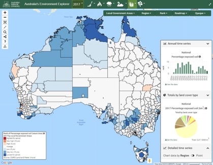
One of the public information services WALD provides is an annual report on Australia’s Environment. The team processes a vast amount of measurements from satellites and on-ground stations using algorithms and prediction models on the National Computation Infrastructure supercomputer. New environmental synthesis data are derived, and these are summarised into an annual report on 15 key environmental indicators, showing how they have changed over time.
Doing so provides valuable experiences that can be incorporated elsewhere in future, for example, in state of the environment reports and environmental-economic accounts. The reporting process relies on data shared freely by Australian and international agencies such as NASA, as well as national research facilities such as the Integrated Marine Observing System, Atlas of Living Australia, and of course, TERN.
“Of particular importance to our annual analysis are long and continuing time-series data that allow us to assess patterns of change in Australia’s ecosystems. That is critical to understanding and managing our environment.”
Prof Albert van Dijk, WALD ANU
The WALD team is currently working hard on a report on 2019 conditions, expected to be released in late March. The data derived for the report are also freely available. Last year, WALD and TERN teamed up to develop the TERN-ANU Landscape Data Visualiser, providing a new ability to visualise, query and compare data produced by the two organisations as well as by others.
