Using AusCover’s data infrastructure, a new research project is helping to improve our understanding of the environmental variables that drive fire in northern Australia.
After completing Masters research about fire frequency and dynamics in Portugal, Sofia Oliveira, a PhD candidate from the School of Agriculture at the Technical University of Lisbon, was drawn to Australia’s tropical savannas to continue her research.
‘I wanted to examine fires in a different environment to Portugal,’ Sofia says. ‘Australia’s tropical savannas are very fire-prone so this was the ideal place to continue my work.’
Working in collaboration with researchers at Charles Darwin University and Bushfires NT, Sofia aims to characterise fire in our tropical savannas. Sofia is using MODIS satellite imagery to determine fire radiative power, which is a measure of fire intensity. She will then be able to examine the relationships between the intensity of fires and major environmental variables, such as seasonality, temperature, relative humidity and wind. Ultimately, she hopes to offer some insight into the question of which environmental variable is the main driver of fire intensity.
AusCover’s data infrastructure is vital to Sofia’s research, because it gives her easy access to a range of fire datasets through the AusCover data portal. She is also using the facility’s remote-sensing data to extract information about meteorological variables such as temperature and water-vapour pressure, enabling her to examine the interplay between environmental variables and fire intensity.
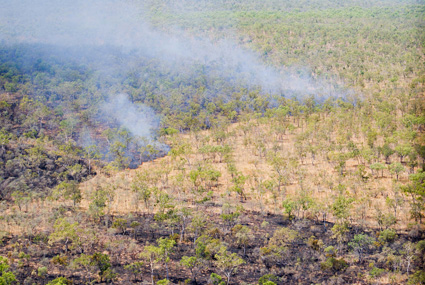
An additional component of Sofia’s work is to improve our understanding of the patchiness of fire, so we can better estimate and measure patchiness using remote-sensing data.
‘When an area is burnt, within the fire perimeter there are some unburnt patches,’ Sofia says. ‘It is important to assess these patches because they are the refuges for biodiversity during fires, and they also affect estimates of greenhouse gas emissions from fire.’
To assess fire patchiness, Sofia has undertaken intensive field work at sites throughout West Arnhem Land. In the next phase of her analysis, she will use this data in concert with remote-sensing data to develop, calibrate and validate an algorithm for estimating fire patchiness from satellite-derived data.
Sofia has enjoyed working in Australia, saying: ‘There was a very positive atmosphere amongst the research community and strong collaborative support amongst researchers, for example by sharing field gear and working together.’
Once completed, Sofia’s work will be available through the North Australian Fire Information website. It will contribute to the growing body of research that is improving our understanding of fire in the Australian landscape and enabling better fire management.
Published in TERN e-Newsletter November 2012
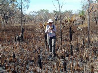
Sofia uses a handheld computer to collect field data for assessing fire patchiness
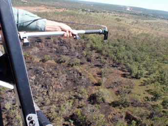
Using a spectrometer to take measurements from a helicopter of the reflectance of burned and unburned areas
