Way back in the early 1900s physicists learned that when cosmic rays from outer space collide with particles in the Earth’s atmosphere and soil, neutrons are created. Now hydrologists can use sensors that measure the energy of neutrons near the Earth’s surface to work out the amount of moisture in soils at scales that can be used in land management and modelling.
The key to this technique is the effect that hydrogen atoms (mainly from soil water) have in reducing the energy of cosmic-ray neutrons.
Until recently, most continuous soil-moisture measurements were made for such small areas that extrapolation across ecosystems and predictions about how landscapes respond to climatic conditions were problematic.
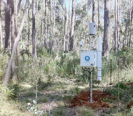
With the new technique, readings are collected from a circular area with a diameter of about 600 m, and, depending on conditions, to a depth of 10 cm to 70 cm below the surface of the ground. Using simple corrections based on readily available data (e.g. humidity, pressure, temperature) and standard calibration procedures, the detectors can provide, almost in real time, measures of soil moisture averaged over about 30 ha.
The technique was developed in the United States, and the National Science Foundation there hosts an international network of sensors, called COSMOS (short for Cosmic-ray Soil Moisture Observing System). Now an Australian network, called CosmOz, has been formed. Among its 11 sensors are two at TERN’s Tumbarumba Wet Eucalypt Supersite and Robson Creek rainforest research site (part of the FNQ Rainforest Supersite).
CSIRO Land and Water research scientist Dr David McJannet is managing the Australian network, and working with scientists at the supersites and in OzFlux.
‘I went to the US last year to learn how to use the technique properly,’ David says.
‘They have a pretty slick interface and a nice way of manipulating the data that we like, but the big thing about this technique is scale. We can measure soil moisture over 30 to 35 ha. That’s ecosystem scale. Before this technique, we were measuring at 10 cm2, and there is such variability in soil moisture at this scale it wasn’t very useful for modelling.
‘By stepping up we get a more accurate big-picture view and information more compatible with models and satellites.’
David said the COSMOS network has agreed to host the Australian data as part of its growing international data portal. The collaboration helps the US and other international collaborators prove that the technique works in widely different landscapes, and Australia gets access to data that allows us to test the validity of our data and our modelling.
The COSMOS network has 60 detectors in the US. It plans to expand to 500 and to cover all continents.
David and several people from TERN facilities – the Australian Supersite Network, the Tumbarumba Wet Eucalypt Supersite of the ASN, and OzFlux – attended a workshop of CosmOz in Brisbane recently to discuss new ways of using the technique.
‘We already use it to test other datasets like satellite soil moisture estimates to make them more reliable,’ David says.
‘We may be able to use the technique to detect changes in the mass of vegetation and leaf litter. For example, with CosmOz we may be able to monitor fuel loads that could help us improve our predictions of the severity of bushfires and where to better direct fire-fighting resources.’
Farmers may also be able to use it to fine-tune irrigation programs, only watering when soil moisture drops to a predetermined level.
TERN Supersite Coordinator Dr Mirko Karan said CSIRO would install two modified detectors on the new 40 m tower above the canopy at Robson Creek to test a method for deriving changes in the canopy biomass over time. The ASN aims to have a sensor at every supersite within five years.
SEQ builds links with Brazil and Nepal
At the SEQ Peri-urban Supersite, international collaborations are helping Australian scientists understand and talk about ecosystems in a quite different way.
Professor Jean-Marc Hero manages the Karawatha Forest node of the supersite. Here the International Program for Planned Biodiversity and Ecosystem Research (PPBio) runs a multidisciplinary research project that involves visiting scientists from Nepal and Brazil.
PPBio began in Brazil, and employs spatially standardised methods of surveying species. The system, called RAPELD, is a grid of uniformly distributed plots that is used to make rapid appraisals of biodiversity during long-term environmental monitoring. Because it is standardised it can be used in different countries and environments.
The Karawatha node is part of a southern Queensland ecological gradient that stretches from sandy coastal ecosystems at Cooloola to the arid red sandplains and mulga of Currawinya. There are three PPBio grids operating in Australasia: at Karawatha; at Lake Broadwater, near Dalby in southern Queensland; and at Currawinya National Park.
Among the international studies being conducted at Karawatha are research projects on plant, fungi and amphibian communities, which are being compared with similar communities in the Amazon.
Standardised datasets can be compared readily, and used for international metadata analysis. Being able to do these things means that people can make more robust comparisons, and this leads to better-informed decisions about how to manage natural resources.
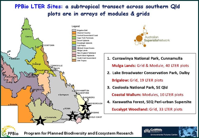
The location of the PPBio sites in Australia
Published in TERN e-Newsletter August 2013
