Due to Commonwealth investment in TERN, for the first time in the history of Australian ecosystem science, infrastructure exists that enables ecosystem scientists to collaborate and share data efficiently and effectively within and between disciplines and all levels of government.
Such collaboration is at the heart of what we do here at TERN – across disciplinary and geographical boundaries, locally, regionally, nationally, internationally. Most of the ecosystem science problems we face are simply too big and too complex to deal with in any other way.
This is why the Commonwealth and state and territory governments are both partners of and stakeholders in TERN. Our researchers are working with government agencies across all states and territories, helping everyone to pull in the same direction to deliver connected capabilities spanning the ecosystem science spectrum.
TERN’s contribution to the National Environmental Research Program
The end of 2014 will mark the end of two four-year rounds of funding of environmental research by the Commonwealth Environmental Research Facilities (CERF) program and the National Environmental Research Program (NERP). The research is organised in hubs, multi-disciplinary groups formed around an environmental topic with a national focus. Through the hubs, some 600 researchers and environmental managers will have taken part in collaborative research involving end-users and stakeholders from every level of government, as well as traditional owners, community groups, private land holders and non-government organisations (NGOs).
Just last week, a working group of TERN’s Australian Centre for Ecological Analyses and Synthesis (ACEAS) facility ran a workshop of people in the research hubs to reflect on the effectiveness of the programs and to identify lessons for future collaborations. At the workshop the three main groups involved – funders, researchers and research users –assessed how well their needs and expectations have been met and identified ways to improve structure, process and practice.
The Director of the NERP Environmental Decisions Hub, Professor Hugh Possingham, was there. He said it was an important chance to synthesise the most important outcomes of almost 10 years of collaboration.
‘It enabled hub leaders from around Australia to reflect on the highlights of the CERF and NERP programs and recognise the factors that that have enabled the program to deliver so many critical environmental outcomes in such an efficient way,’ says Hugh.
It was also a great environment for the collaborators to learn from each other, he said.
The workshop’s findings will be used by NERP research hub leaders around Australia to inform improvement of future processes and practices in the environmental funding space.
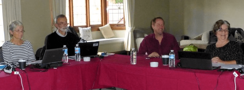
Participants at last week’s ACEAS workshop reflecting on the CERF/NERP programs. Left to right: Judy West of the Department of Environment and the Australian National Botanic Gardens, Nic Bax of University of Tasmania, Hugh Possingham of the NERP Environmental Decisions Hub and Di Tarte of Marine Ecosystems Policy Advisors Pty Ltd (Photo courtesy Alison Specht).
ACEAS has also been collaborating with NERP on another research project. This group, which is linked to two NERP research projects aimed at integrating data, modelling, governance, and management in northern Australia study regions, has produced a landmark framework for catchment-to-coast planning.
Also in the north, another of TERN’s facilities, the Australian Coastal Ecosystems Facility (ACEF) is supporting a project being led by the CSIRO as part of the Northern Australia NERP hub to help us understand what is likely to happen to Kakadu’s wetlands as sea levels rise.
TERN joins ABARES alliance to provide easy visualisation of data
Land-use decision-makers, including natural resource management groups, agricultural scientists and policymakers, often need to combine and analyse large amounts of environmental, social and economic information.
A new software tool, the Multi-Criteria Analysis Shell for Spatial Decision Support (MCAS-S) makes this process a whole lot easier. Developed by the Australian Bureau of Agricultural and Resource Economics and Sciences (ABARES), MCAS-S allows users to: view and classify map layers; adapt and combine map layers in ways that provide insight into key relationships; and produce statistical reports for regions simply and quickly.
TERN has recently joined the collaborative project that includes ABARES, NSW Office of Environment and Heritage, Australian Collaborative Land Use and Management Program, NERP Landscapes and Policy Hub, and Barry Consulting.
The tool allows complex data to be more readily understood by bringing multi-criteria analysis into the decision-makers’ realm. MCAS-S has already been applied to several types of issues: forestry and reef management, wildfire assessment, wild dog control, and risk management of animal disease.
States cooperate to provide national perspective 
Australia’s history is replete with examples of lack of cooperation between state and federal governments – just look at railway gauges across the country. Attempts to agree on a national stance on ecosystem health are often as stymied as other fields of endeavour by the simple question: What’s in it for the states? TERN’s various infrastructure is able to work around such ingrained traditions and provide a national perspective.
TERN’s Eco-informatics facility has built and sustained strong relationships with data custodians in state agencies via the Data Custodian Reference Group, which has been established for more three years to help facilitate the publication of data in the Australian Ecological Knowledge and Observation System (ÆKOS). It also has established a Data Users Reference Group of early-career researchers, academics and ecologists from universities, governments, NGOs and private consultancies to help guide product enhancements to suit a broad spectrum of users and encourage the re-use of data.
The facility has 11 data partnerships that have generated 22 open licences for 22 ecological datasets. Memorandum of understanding-style documents as well as formal licensing arrangements facilitate the ingestion of ecological data into the AEKOS data portal.
South Australia’s Department of Environment, Water and Natural Resources (DEWNR) is one agency in such a partnership with TERN. The Director of Science, Monitoring and Knowledge at DEWNR, Ms Sandy Carruthers says: ‘The TERN ÆKOS system is delivering something that is truly useful in supporting ecological research and analysis capabilities, and will end up complementing our broad base of natural resource management information systems.’
Another collaborator is Western Australia’s Department for Environment and Conservation, which has made data from its Ravensthorpe Range Flora Survey available via ÆKOS.
Dr Margaret Byrne, the Director of the department’s science division, said the department supported publishing its datasets in ÆKOS as it gave Australia’s ecosystem science researchers an opportunity to add value to the state’s investment.
‘The information framework adopted by ÆKOS fills a gap in our department as it allows data users to fully appreciate the richness of the flora of Ravensthorpe Range, and describes our collection methods, which is important as it helps to reduces potential misuse of our data,’ Margaret says.
There are many other noteworthy examples of the ways in which TERN’s environment and landscape research infrastructure made possible greater collaboration and cooperation within and between government agencies. Here are four to illustrate the spectrum.
- The national soil-landscape products developed by TERN’s Soils and Landscape Grid of Australia incorporate regional datasets that are beginning to be used by state and territory governments across the country.
- TERN’s AusCover facility is at the forefront of efforts to help refine, expand, and improve one of the key information tools used by fire management agencies across all states and territories.
- TERN’s Australian Supersite Network, in cooperation with the WA Department of Parks and Wildlife (DPaW) and CSIRO, has established a multi-purpose field study centre in the internationally significant Great Western Woodlands region of Western Australia.
- TERN’s OzFlux network is sharing data it has collected with the WA Department of Water to help researchers understand Perth’s declining water tables.
Published in TERN newsletter April 2014
