International funding has just been secured for the creation of a new international network that will utilize infrastructure, collaborations and expertise developed through TERN’s AusCover Facility, to measure and monitor change to terrestrial biomass and carbon in our environment.
Tools that allow researchers to see natural phenomena in new ways and at new scales have always led to development and refinement of theory and models, thus providing pathways to contribute to new scientific knowledge. To this end, better and more accurate measurement of aboveground biomass at fine scales leads to new insights in the carbon metabolism of forests—vital information for improving our carbon inventories and ecosystem monitoring abilities.
As a result of collaborative projects and field programs over the past five years at TERN SuperSites, and a number of other satellite calibration sites, AusCover activities and partners have helped to develop data collection, processing, storage and visualisation methods that have become international standards.
Terrestrial laser scanners (TLS) are laser ranging systems that produce a 3-dimensional measurement of an environment. Although these systems are used extensively for precision surveying and measurement, the methods for using them to measure vegetation structural properties has been limited. TERN AusCover staff have been highly active internationally in building this capability and this new grant is a significant step in making the technology and methods more accessible.
The US National Science Foundation (NSF) has officially funded a new 5-year project that will:
- Compliment build on existing TERN expertise and collaborative work to develop new low-cost Terrestrial Laser Scanning (TLS) instruments able to provide fast and consistent aboveground biomass estimates in terrestrial ecosystems; and
- develop new ecological applications of TLS using both commercial and research scanners.
A more widely-available fully calibrated waveform LiDAR scanner could be the key to better assessment of vegetation biomass, carbon inventory and ecosystem monitoring at regional and coarser spatial scales. This, in turn, will make an important contribution to global carbon measuring and management through programs like the United Nations’ “Reducing Emissions from Deforestation and Forest Degradation” (REDD+) project, which aims to create a financial value for the carbon stored in forests.
Moreover, the project hopes to have a significant social impact by encouraging the participation of underrepresented groups within the science community, serving the broader goal of diversity in practitioners of science.
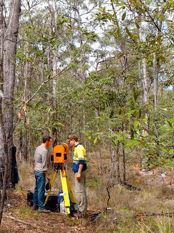 | 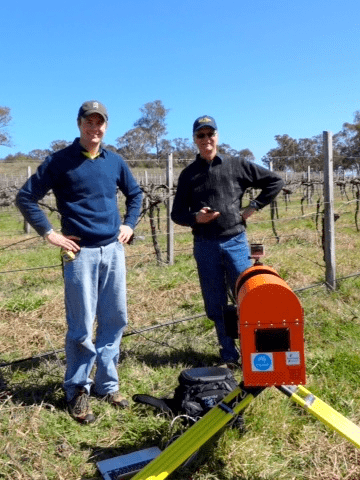 | 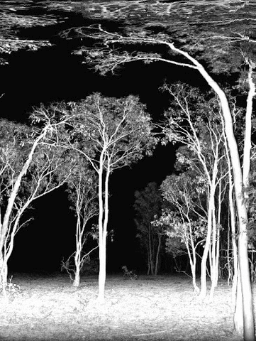 |
| Terrestrial laser scanners (TLS), like the DWEL scanner being used by AusCover members Stuart Phinn, Michael Schaefer and Alex Held at Karawatha Forest (left) and at a NSW vineyard (centre), are laser ranging systems that produce 3D measurements of vegetation structural properties (similar to the sample image from Mulligan Flat Nature Reserve shown above right). TERN AusCover staff have been highly active internationally in building this capability and this new grant is a significant step in making the technology and methods more accessible. The new project will compliment and utilize the infrastructure and expert networks provided by AusCover as well as the wealth of information already collected at the TERN Supersites, to develop better methodologies to estimate biomass and carbon stocks in complex forest ecosystems such as those with significant carbon held in the understory and not just the forest overstorey. | ||
Five years of funding at about $100,000 USD per year will be used primarily to sponsor:
- Collaborative workshops for LiDAR builders, users, and ecologists and meetings of technology developers working on the low-cost scanner plan;
- Steering committee meetings to guide the project and set future goals;
- Inter-calibration activities that will be used to test and compare terrestrial laser scanning (TLS) technology and other techniques for measuring and monitoring vegetation—similar to the activities of the Terrestrial Laser Scanning International Interest Group (TLSIIG) at TERN’s SEQ Peri-urban Supersite in 2013; and
- Annual researcher exchanges between Australia and the US.
The project not only represents a fantastic opportunity for international collaboration between Australia and the US, but also presents opportunities cooperation and coordinated funding from European and Australian funding agencies involved in similar research.
The project will compliment and utilize the infrastructure and expert networks provided by AusCover as well as the wealth of information already collected at the TERN Supersites, to develop better methodologies to estimate biomass and carbon stocks in complex forest ecosystems such as those with significant carbon held in the understory and not just the forest overstorey.
Several members AusCover will be involved with the project, including Alex Held, Stuart Phinn, and Michael Schaefer, and it will include key AusCover partners, specifically the Queensland Department of Science, Information Technology and Innovation.
TERN is looking forward to the next five years of collaborative ecosystem science and practical applications of TLS via the project. Keep an eye out in upcoming TERN eNewsletters for updates on this project.
- For more information on this project please contact AusCover’s Director, Alex Held.
#!!rs/common/flowplayer/flowplayer:file_name=730_laser_vision.mp4:auto_play=no!!#
The new project funding will support Inter-calibration activities that will be used to test and compare terrestrial laser scanning (TLS) technology and other techniques for measuring and monitoring vegetation—similar to the activities of the Terrestrial Laser Scanning International Interest Group (TLSIIG) at TERN’s SEQ Peri-urban Supersite in 2013, which drew the attention of the ABC’s 7:30 (Video courtesy of ABC)
Published in TERN newsletter April 2015
