National scale soils information is critical for informing decisions across domains in environment, agriculture, engineering, and climate response, and enables researchers to measure changes in Australia’s ecosystems over time from local to continental scales. We talk to outgoing TERN platform co-lead, Mike Grundy, about the immense value digital soil mapping and assessment adds to a national landscape observatory.
Digital soil mapping and assessment (DSMA) is changing the way we collect and use soil information. It combines artificial intelligence (AI) and statistical tools with modelling to produce information on a range of soil attributes over time and space. TERN uses DSMA in building information infrastructure and has supported its development across agencies and scientists.
It is both a key source of new soil and land information and an effective means for integration across many providers and data systems; it can create new value from existing and disparate data.
Used well, it offers increased objectivity, utility and flexibility for users, says TERN’s outgoing Landscapes platform co-lead, Mike Grundy, who has been instrumental in the development of DSMA in Australia and overseas. DSMA approaches allowed TERN to build the Soil and Landscape Grid of Australia.
“So fundamental is appropriate information on the soil resource, through TERN it has been recognised as essential national infrastructure and DSMA in its various forms is the key means for the capture and sharing of this information.
Digital soil mapping can enable a wider range of pathways to impact due to increased connections to data streams, modelling, decision support systems and to the increased access to machine learning and data analytics.
In TERN, we are using DSMA and related technologies to bridge across the TERN platforms so that the observatory connects to and brings together the rich information elements we are collecting. We also use it to connect to data systems across the country and data streams from local sensors to satellites.”
Mike Grundy, former TERN Landscapes platform co-lead and CSIRO Research Director.
To better understand and quantify the pathways to impact enabled by DSMA, Mike and a team of about 30 from across Australia, NZ and France have analysed the outcomes and emerging impacts of DSMA offerings from Australia and abroad.
Included in the analysis is the landmark TERN Soil and Landscape Grid of Australia (SLGA), which provides relevant, consistent, comprehensive, nation-wide data in easily accessible formats.

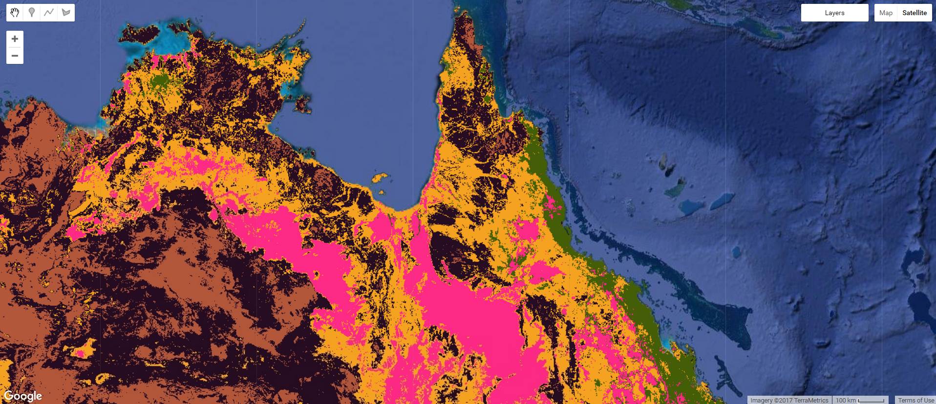
TERN’s Soil and Landscape Grid, available online and via Google Earth Engine (above), provides a range of soil and landscape attribute products from existing databases, new sensor measurements and novel spatial modelling, at a fine spatial resolution (3 arc-seconds or approximately 90 x 90 m pixels)
Australia’s soil grid aids real-world decision making
Since the launch of the SLGA, the data have consistently been amongst the most downloaded from TERN. There have been over 1.3 million downloads—more than 168 terabytes of soil data—using the SLGA infrastructure from NCRIS-enabled TERN. The demand shows no signs of abating.
SLGA data are being accessed by user groups that include Government agencies, agriculture industry advisors, software developers, infrastructure and engineering consultancy firms, environmental consultants, environmental and agricultural researchers, educational institutions and private individuals.
“We’ve always known that the SLGA outputs were being used to generate outcomes, but until now, we didn’t have a complete understanding of the impacts and, in particular, the extent to which major stakeholders were using it in addressing land management issues.
It’s exciting to be able to report that the numbers are backed up by equally impressive science and natural resource management impacts.
Our analysis has revealed that the SLGA has been used in applications including climate modelling; agricultural system adaptation analyses; landscape change events such as post-fire erosion; assessments of the vulnerability of valued landscapes to extreme events; groundwater recharge calculations; soil carbon stock analyses; as well as health and disease research for livestock and people.
There have also been a range of biodiversity applications including broad-scale ecological transitions, ecological shift due to aridity; adaptation of animals to heat stress; and the habitats of endangered species.
It is also an important component of Australia’s recurring State of Environment Report.”
Mike Grundy, former TERN Landscapes platform co-lead
Mike and the team’s analysis via communications with end-users suggests that TERN-delivered DSMA data are indeed being used in real-world decision making, and the breadth of use is sometimes surprising.
However, they also point out that the impact pathways are, to some extent, hidden and require in-depth tracking from outputs (e.g. data downloads), to outcomes (e.g. publications), to impacts (e.g. decision-making). Knowing how that works in complex decision-making will guide how we design and release new DSMA and TERN products.
How to improve impact tracking
To better facilitate the tracking of impact pathways from DSMA (and all other forms of national research infrastructure) the researchers suggest the incorporation of a design feature that captures the use and intent of data access.
TERN whole-heartedly supports this recommendation because it will help TERN to improve its user services to better meet stakeholders’ needs while demonstrating to TERN’s funders the benefits arising from their investments in national research infrastructure for Australia.
Additionally, acknowledging NCRIS-enabled TERN in research outputs provides government granting agencies with a metric that records how the infrastructure is being used, along with searchable information about outputs, outcomes and pathways to impact. This then benefits TERN’s case for ongoing funding to enhance Australia’s ecosystem infrastructure so it continues to supply continuously growing long-term terrestrial ecosystem data for Australian researchers.
- Access the TERN Soil and Landscape Grid of Australia
- The continental-scale SLGA complements TERN’s on-ground soil survey data and samples collected at more than 750 monitoring plots around Australia.
- If you have used or are using TERN data, please let us know via the quick and easy self-reporting form on our website.
