Australia is a global leader in Earth observation thanks in part to TERN technologies, infrastructure and tools. Our ability to continue supporting Australian science communities in undertaking global impact science has been strengthened thanks to recent collaborations on the world science stage.
Australia is one of the world’s largest users of remotely sensed Earth observation (EO) data. The sheer scale of Australia’s vast terrestrial and marine territory—about 1/10 of the earth’s surface—combined with low population density and a limited number of on-ground monitoring systems explain this reliance on remote sensing, including satellite and lidar technologies.
TERN’s land observatory plays a vital role in coordinating and delivering EO data in Australia. The network brings together many disparate earth observation research teams and provides national coordination, standardisation and open-access to EO data and derived products.
Together with our partners, we provide ground-based validation and calibration services and in-situ data collection and algorithm development in support of international satellite programs as well as domestic cross disciplinary science activities.
Government agencies, research institutions, agricultural industry, environmental management agencies, and private companies all use TERN-delivered remotely sensed data for improved science and decision-making.
We’re pleased to report that TERN’s ability to continue supporting Australian science communities in delivering bioacoustics research, infrastructures and services has been strengthened thanks to recent collaborations on the world science stage.
Leading lights of laser scanning converge
Mick Schaefer and Alex Held of CSIRO, together with Peter Scarth and Stuart Phinn of the University of Queensland, were invited to attend a Royal Society-sponsored meeting on terrestrial laser scanning (TLS) in London as Australia’s delegates.
At the meeting, which was titled ‘The terrestrial laser scanning revolution in forest ecology’, Peter and Mick met with the leading lights of land-based remote sensing from more than a dozen countries and presented on TERN’s collaborative Australia-wide EO infrastructure and the research it facilitates.
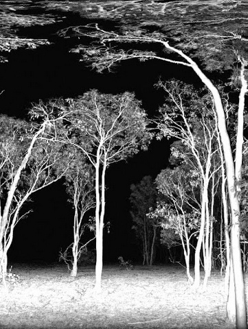
“Terrestrial laser scanners [TLS] allow vegetation structure, characteristics and health to be determined in more detail than ever before,” says Mick. “This can then be used to inform decisions on environmental issues such as weed management, biomass and carbon accounting, and managing fuel loads.”
“It was great to have an opportunity to present our work and TERN’s infrastructure to an international audience, and to see so many other nations interested in what we’re doing here in Australia.”
Australia’s Earth observation infrastructure a global success model thanks to TERN
Professor Emeritus Alan Strahler of Boston University and leader of the Terrestrial Lidar Scanning Research Coordination Network was at the meeting and says that Australia’s level of coordination and EO data collection and dissemination infrastructure is held up as an international model of success.
“Australia is a global leader in Earth observation, and is very far-sighted in the way it provides the infrastructure to deliver environmental satellite and ground data to users,” says Alan.
“TERN has not only pioneered the concepts and technologies that bring disparate earth observation data streams together, but is also providing the specialized tools needed to use them to solve problems in land and resource management.
The presentations by Mick and Peter provided a tour de force in showing the way forward to the TLS community and beyond.”
Facilitating high impact ecosystem science
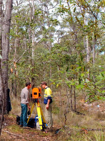
Mick, Peter, Alex and Stuart are all part of the Terrestrial Laser Scanning International Interest Group (TLSIIG), a global network of researchers advancing our understanding and application of portable imaging instruments for measuring and monitoring ecosystems.
TLSIIG uses TERN AusCover data infrastructure to publish and share data that comes out of the field campaigns, ensuring that their work is accessible to researchers across the globe.
The partnership, and indeed the links furthered at international meetings like the recent Royal Society workshop, increases the reach and uptake of our combined data resources, infrastructure and processing methods to better enable high impact, cross-disciplinary science.
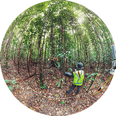
The Terrestrial Laser Scanning International Interest Group (TLSIIG) uses TERN AusCover data infrastructure to publish and share data that comes out of the field campaigns—similar to the one at TERN’s SEQ Peri-urban Supersite in 2013 which drew the attention of the ABC’s 7:30—ensuring that their work is accessible to researchers across the globe (Video courtesy of ABC)
