Dr Andries Potgieter of the University of Queensland is using TERN delivered remote sensing data to estimate grain cropping area and produce regular seasonal outlooks for sorghum and wheat. When faced with the high impact of climate variability, advanced knowledge of likely crop size and its geographical distribution help industry make strategic decisions and avoid market volatility within Australia and globally.

Commodity forecasting is an essential part of decision-making processes in Australian agricultural businesses and government agencies. However, the lack of real-time data on cropping area meant that producing accurate and timely predictions of specific production across regions and seasons wasn’t possible until recently.
Thanks to the open satellite data delivered by TERN, Dr Andries Potgieter and his colleagues at The University Of Queensland’s Queensland Alliance for Agriculture and Food Innovation have bridged this information gap and developed a holistic approach to determining specific crop production estimates.
Andries’s remote sensing techniques also provide vital information on trends in land use patterns across regions and seasons and are provided to both federal and state government agricultural departments and used in monitoring, planning and risk mitigation.
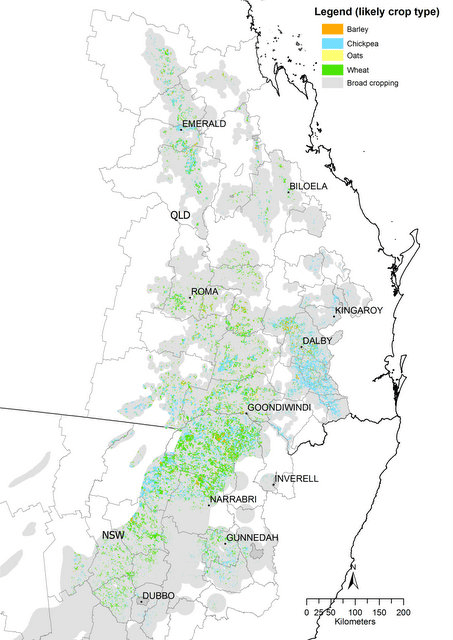 |
| Crop area estimates for North-East Australia’s main winter crops for the 2016 winter season created using MODIS satellite imagery from TERN |
TERN’s near real-time satellite data enable early and accurate crop forecasts
To calculate specific crop area estimates Andries and the QAAFI team use MODIS satellite imagery from TERN to produce time series data over cropping periods showing changes in green vegetation.
This remotely-sensed data is then calibrated for accuracy using QAAFI’s data collection tool called Paddock Watch, which uses citizen science to gather data on crop type at field scale. Following this validation process, area estimates are combined with yield estimates from crop models to produce both aggregated area and production totals for the main crops for each season.
“The availability of up-to-date and open satellite data via TERN means that we’re able to produce both early-season and ensuing end-of-season crop area estimates at the shire scale,” says Andries. “Without the TERN data this wouldn’t be possible.”
Reduced risk and improved economic viability for industry and business
More accurate and timely estimates of crop area and yield for industry and business play a significant role in avoiding market and climate volatility within Australia and globally say Andries.
“When faced with the high impact of climate variability, advance knowledge of likely crop size and its geographical distribution within a specific season can help industry make strategic decisions such as forward buying or selling of grain well ahead of harvest,” says Andries.
“Our forecasting also allows industry to shift resources from one region to another depending on supply and demand, and hedge risk by buying insurance against crop loss, due to lack of rainfall, well before harvest. Reducing risk increases the economic viability of industry over the long-term.”
Improved decision making for government
Andries’s seasonal outlooks are released via QAAFI’s website and also directly provided to both federal and state government agencies.
“I work closely with both ABARES and the Queensland Department of Agriculture and Fisheries who use the forecasts to more accurately and objectively determine crop productivity,” says Andries.
“They also use them to determine the spatial impact and magnitude of drought on farm productivity in exceptional circumstances declared areas.”
“The forecasts we produce, and indeed the TERN delivered data they rely on, are now a very important part of our nation’s agricultural observation and management systems.”
- QAAFI is a research institute of the University of Queensland supported by the Queensland Department of Agriculture and Fisheries.
- The satellite images Andries uses (Normalised difference vegetation index (NDVI) and Enhanced vegetation index (EVI) – MODIS, MOD13Q1(c5) mosaic) is openly available alongside other land cover dynamics and phenology datasets via the TERN AusCover website.
- For more information on the methodologies and applications used in this work please contact Andries directly.
- For more information on TERN’s open remote sensing data visit our website.
- TERN is facilitating science that is enabling sustainable and enhanced productivity of our food, fibre, fuel and natural resource based industries and is offering greater efficiency and effectiveness in environmental monitoring and assessment. To read more about this work download TERN’s Industry Engagement Plan.
Dr Andries Potgieter’s seasonal outlooks for sorghum and wheat are released via QAAFI’s website and also directly provided to both federal and state government agencies where they are used to more accurately and objectively determine crop productivity and to determine the spatial impact and magnitude of drought on farm productivity in exceptional circumstances declared areas
Published in TERN newsletter July 2017
