News

Taking TERN soil tools to near neighbours and beyond

TERN’s Soil and Landscape Grid of Australia continues to be used as regional role model and template in international cooperative soil information management. The Grid has recently been on show at the FAO in Rome and used in a suite of skill development and training projects with our near neighbours and beyond including Indonesia, Taiwan, Russia and Canada.

TERN’s Soil and Landscape Grid of Australia is
an essential piece of national information
infrastructure, required to support informed use
and management of our soil and landscapes

TERN’s Soil and Landscape Grid of Australia provides easy access to nationally-consistent and comprehensive soil and landscape data at a finer resolution than ever before in Australia. The Grid is an essential piece of national information infrastructure, required to support informed use and management of our soil and landscapes.

With this infrastructure and capability in hand, Australia is having a widespread international influence through the development and refinement of the data collection methods and processes needed to build and share global equivalent of what the Grid is in Australia and the first digital soil map of the world: GlobalSoilMap.​

The Grid on show at the FAO in Rome

Collaboration and knowledge sharing undertaken by the Soil and Landscape Grid of Australia since its inception have influenced the development of the global specifications and the implementation of the GlobalSoilMap.

Such collaboration and Australian led developments were in evidence at the recent Global Symposium on Soil Organic Carbon hosted by the FAO in Rome.

Collaborators in the Soil and Landscape Grid of Australia from the CSIRO demonstrated to the global soil information community some of the practical applications that have been made in Australia using the Grid and its data.

New science using the Grid was showcased in two presentations at the conference: ‘New Measurement and Mapping of Soil Organic Carbon in Australia supports national carbon accounting and monitoring’ and ‘Measuring and monitoring soil carbon stocks from point to continental scale in Australia’.

Mr Mike Grundy, a Research Director within CSIRO’s Agriculture and Food unit, said that the presentations generated much interest in the Grid and people were particularly impressed by the way in which it has transformed the nature of soil information, marrying soil data to advances in measurement, modelling and inference, so that new synthesis and analysis is now possible.

“More is possible, especially when we see the development of on-ground observations and sensing, long term sites and streams of remote sensing connected to the Soil Grid emerging from TERN,” commented Mike.

International partnerships and skills training to help address land management challenges

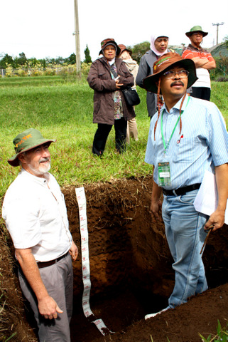
More locally, TERN’s Soil and Landscape Grid of Australia team has recently been partnering on soil infrastructure projects with a number of nations in our region, including Indonesia, New ZealandSouth Korea and Taiwan.

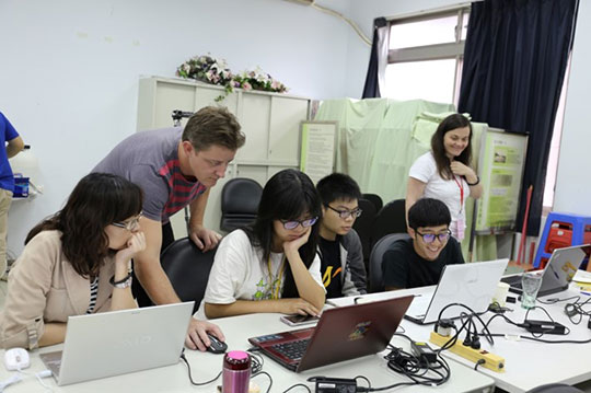
In one such international collaborative project, TERN’s Soil and Landscape Grid of Australia, together with partners at the University of Sydney, have been providing training and expertise in advanced methods of digital soil mapping to local researchers, graduate students, and Taiwanese Government scientists at the National Taiwan University (NTU), Taipei.

“The training course was really hands-on, practical and built around sharing of knowledge and skills in the production of the new soil grids, information modelling, communication activities and common approaches to building regional soil information capacities,” says Dr Brendan Malone of the University of Sydney.

Further from home, similar training courses have recently been conducted in Canada, Italy and, arguably the home of soil science, Russia.

“Partnerships with other countries are great opportunities for Australia to share its knowledge and expertise and help some our neighbours address their own complex land management challenges and make steps towards a global soil map,” says Brendan.

The global reach and influence of TERN, and Australia’s science community as a whole, is not only creating important scientific networks but also strengthening Australia’s international relations. By sharing our scientific knowledge and techniques, in this case soil information infrastructure, TERN is helping to address the environmental management challenges we face, both in Australia and globally.

TERN’s Soil and Landscape Grid of Australia, together with partners at the University of Sydney, have been providing training and expertise in advanced methods of digital soil mapping to local researchers, graduate students, and Taiwanese Government scientists at the National Taiwan University in Taipei (Photo courtesy of Brendan Malone)
Mike Grundy (CSIRO) and Markus Andas (Indonesian Centre for Agricultural Land Research and Development) discuss the attributes of the fertile soils of Cianjur region of West Java during the extensive training program within Indonesia and Australia in 2013 (Photo courtesy of Claire Harris)

Share Article