
Bird’s-eye view of a prescribed burn
The frequency and intensity of disturbances in northern Australia, such as cyclones and fires, have profound effects on ecosystem structure and composition, carbon emissions, and landscape productivity, just to name a few. TERN’s AusCover Facility is currently working to further understand such disturbances to enable communities and land managers to plan, innovate and manage this dynamic environment with greater confidence and success than has previously been possible.
A recent collaborative study took advantage of TERN’s infrastructure and utilised AusCover data to investigate the relationships between cyclone events and greenhouse gas emissions from northern Australia’s tropical savannas. This was done by assessing the amount of vegetation damaged by the cyclone’s winds. Collaborative ground-breaking research such as this will play an important role in understanding how best to offset Australia’s carbon footprint and contribute to the effective management of our unique ecosystems.
The AusCover team is also collaborating with the Indigenous Land Corporation, Greening Australia and The Nature Conservancy in a Carbon Farming Initiative (CFI) savanna-burning project. Under the project, Indigenous landholders have intentionally burnt savannah grass cover early in the past two dry seasons to reduce fuel loads, which, in turn, has reduced the severity of late-season fires and resulted in fewer carbon emissions. By using satellite imagery of the region, AusCover determines the area and intensity of fires that occur. The imagery is then validated via on-ground surveys enabling the research team to determine the carbon emissions resulting from fires with a high degree of confidence.
There are also plans to develop and test historical fire scar mapping using Landsat data across the whole of the top end, from the Kimberley in Western Australia, through the Northern Territory, to northern Queensland. The intention is to trial and validate an approach developed by Queensland’s Department of Science, Information Technology, Innovation and the Arts’ (DSITIA) Remote Sensing Centre and the Joint Remote Sensing Research Program in collaboration with both the NT and WA governments. These collaborations will leverage TERN’s AusCover infrastructure to assist with data and knowledge sharing and delivery, helping to make such an ambitious project successful.
Data snapshot:
AusCover researchers are using this gross primary productivity data to study the effects cyclones are having on carbon storage in savanna ecosystems. This calibrated and validated fire frequency data is being used in the savanna-burning project assist in lowering carbon emissions.
Recent publications:
Edwards, A. C., Maier, S. W., Hutley, L. B., Williams, R. J., & Russell-Smith, J. (2013). Spectral analysis of fire severity in north Australian tropical savannas. Remote Sensing of Environment, 136(0), 56-65. doi: http://dx.doi.org/10.1016/j.rse.2013.04.013. Available online.
Hutley, L., Evans, B., Beringer, J., Cook, G., Maier, S., & Razon, E. (2013). Impacts of an extreme cyclone event on landscape-scale savanna fire, productivity and greenhouse gas emissions. Environmental Research Letters, 8(4), 045023. Available online.
Smith, T. E. L., Paton-Walsh, C., Meyer, C. P., Cook, G. D., Maier, S. W., Russell-Smith, J., . . . Yates, C. P. (2014). New emission factors for Australian vegetation fires measured using open-path Fourier transform infrared spectroscopy – Part 2: Australian tropical savanna fires. Atmos. Chem. Phys. Discuss., 14(5), 6311-6360. doi: 10.5194/acpd-14-6311-2014. Available online.
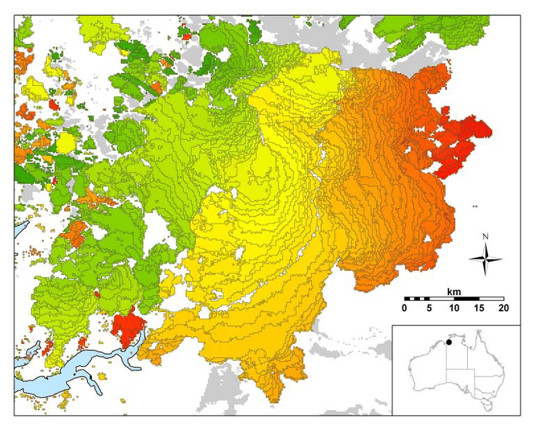
Example of burnt-area map for 2008 in northern Australia made using MODIS data. The different colours indicate different days between 1 June and 15 September 2008 when an area was burnt, and the grey indicates the areas burnt between 1 January and 31 May 2008.
Published in TERN newsletter March 2014
