In a giant leap towards the creation of Australia’s first nationwide mangrove observing system, TERN has provided open access to decades of historical and newly acquired field and Earth observation data. These data alert scientists and managers to coastal environmental change, provide new knowledge on the causes and impacts of this change, and support the sustainable management of our immensely important mangrove ecosystems. The data also enhance Australia’s contribution to achieving the global Sustainable Development Goals.
Mangrove ecosystems are a vital part of Australia’s environment. They support faunal biodiversity, filter pollutants, protect estuaries and marine ecosystems from sedimentation and reduce coastal erosion and storm damage. They also store up to 40 times more carbon than terrestrial forests, hence their ‘blue carbon ecosystem’ tag.
Despite being protected by state, national and international legislation, the vulnerability of these valuable ecosystems to adverse environmental change was exposed in 2016, when about 10,000 hectares (or about 10,000 rugby fields) of mangroves along Australia’s northern coast suffered rapid dieback.
The event was not identified until several months later, which highlighted the urgent need for a national mangrove observing system that is fully integrated with existing environmental monitoring initiatives.
An observing system that goes beyond the initial alert and provides information on future trends in response to varying environmental conditions is required. TERN is making a major contribution towards such a system by collating a diverse range of existing datasets, acquiring new field and Earth observation (EO) data, and generating derived data products.
Decades of historical mangrove data and imagery now openly available via TERN
Over past decades, a large number of field-based measurements have been collected or acquired on mangroves around Australia but often not released into the public domain for use. Recognising this, TERN has identified, collated and published these data, in common format with metadata, for open access.
One of the key mangrove datasets now openly available via TERN is multi-scale field measurements of mangrove floristics, structure and biomass supported by a diverse range of airborne imagery collected since the 1950s. Black and white and colour aerial photographs are now available alongside multispectral and hyperspectral imagery captured by drones, aircraft and satellites.
TERN has worked with Geoscience Australia (GA) to make available maps of mangrove extent produced by the Japan Aerospace Exploration Agency (JAXA) Kyoto and Carbon (K&C) Global Mangrove Watch project through Digital Earth Australia’s Open Data Cube (ODC).
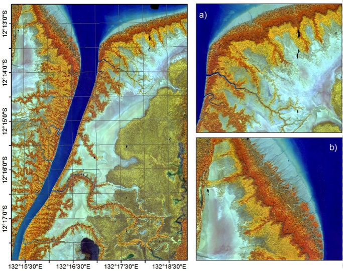
Time-series data showing mangrove extent and canopy cover at a 25m resolution from 1987 to 2016 are now openly available through both the data cube and TERN.
It’s not just Australia that’s set to benefit from these data and methods. TERN and GA are collaborating with Vietnam to process satellite imagery of the Mekong River—with the results of this work being used to validate whether the methodology can be applied around the globe.
New remote-sensing data for near real-time mangrove monitoring
TERN is investing in remote sensing and Earth observation (EO) techniques to collate near real-time data. For example, in 2017 TERN collected airborne LiDAR and digital photography along the entire coastline of the Gulf of Carpentaria.
Ultra high-definition imagery and data is now openly available via TERN thanks to collaboration with The National Environmental Science Program (NESP), Airborne Research Australia, the University of New South Wales (UNSW), Charles Darwin University, the Queensland Government’s Departments of Environment and Science and Agriculture and Fisheries, Riegl Laser Measurement Systems GmbH and the Hackett Foundation.
Professor Richard Lucas, of UNSW and Aberystwyth University in Wales, says that the dataset provides a vital basis for observing change and ensuring the long-term health and services of mangroves in the region.
“This TERN dataset represents the largest single dedicated acquisition of LiDAR and aerial imagery over a mangrove ecosystem anywhere in the world,” says Richard. “It’s a baseline that can play a key role in understanding how this dynamic ecosystem is responding to environmental change in Australia.”
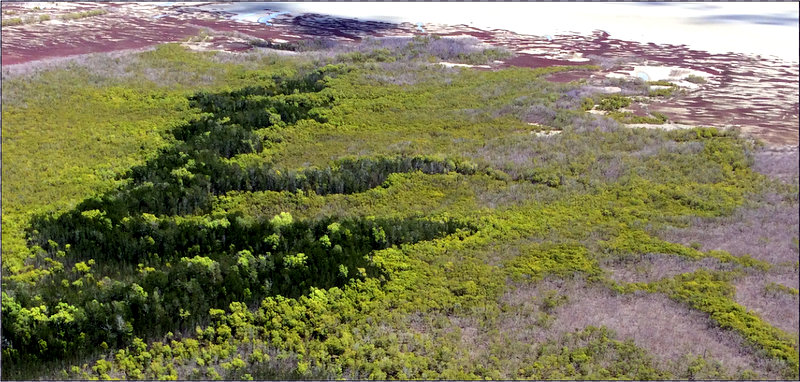
High-resolution airborne imagery collected by TERN in 2017 along the entire coastline of the Gulf of Carpentaria, including this section along the Roper River, documents significant mangrove dieback and is now openly available for download (imagery courtesy of Google Earth and Airborne Research Australia)
Data to inform national and global policy
The ultimate goal of TERN’s mangrove observing system is to foster the protection and sustainable management of these ecosystems in Australia, recognising their vital environmental, societal and economic roles.
“The data contained in the system are of vital importance to the ongoing management of our mangrove ecosystems by both state and federal agencies” says Alex Held, of CSIRO and TERN’s Land Observatory platform.
This view is shared by Professor Graciela Metternicht, of UNSW and the IUCN Commission on Ecosystem Management, adding that “data and systems like this one can inform environmental policy in Australia and will allow the nation to contribute to international environmental conventions including the United Nations Sustainable Development Goals (UN SDGs)—in particular, Goal 15, that focuses on protecting, restoring and promoting sustainable use of terrestrial and inland freshwater ecosystems”.
It is hoped that TERN’s efforts in creating this observing system will lead to routine monitoring of mangroves at a national level with input from an expert community in Australia and internationally.
- Access the open data and imagery in TERN’s Mangrove Data Portal.
- You can play a role in strengthening this dataset by contributing your own data through the portal. If you require any assistance with this or would like to know more, the please contact us at tern@uq.edu.au