
Staying at the forefront of long-term environmental monitoring means keeping a close eye on emerging technologies. TERN’s involvement with drone-based remote sensing is a great example of this. Through initiatives like Dronescape TERN is working closely with researchers around the country to explore how drone technologies can provide a vital layer of ecosystem data which promise to generate a more comprehensive picture of ecosystem processes across Australia’s diverse and sometimes inaccessible landscapes. We’re also gearing up to take advantage of the next wave of drone technologies, which will take aerial remote sensing to a whole new level.
From the outset, satellite and aircraft-level remote sensing technologies have been an essential feature of TERN’s infrastructure. They are vital for regional and continental-scale monitoring, offering opportunities to collect data and track long-term ecosystem change over large areas. They also provide valuable environmental information about hard-to-reach areas where ground-based field data is sparse or non-existent.
There are trade-offs though. Broad spatial coverage comes at the cost of resolution, which means capturing data from large areas involves sacrificing fine-scale ecological details. Meanwhile, the costs and logistics of remote sensing via satellite and aircraft limit how often data can be collected. This constrains the study of important ecosystem processes that unfold over short time frames.
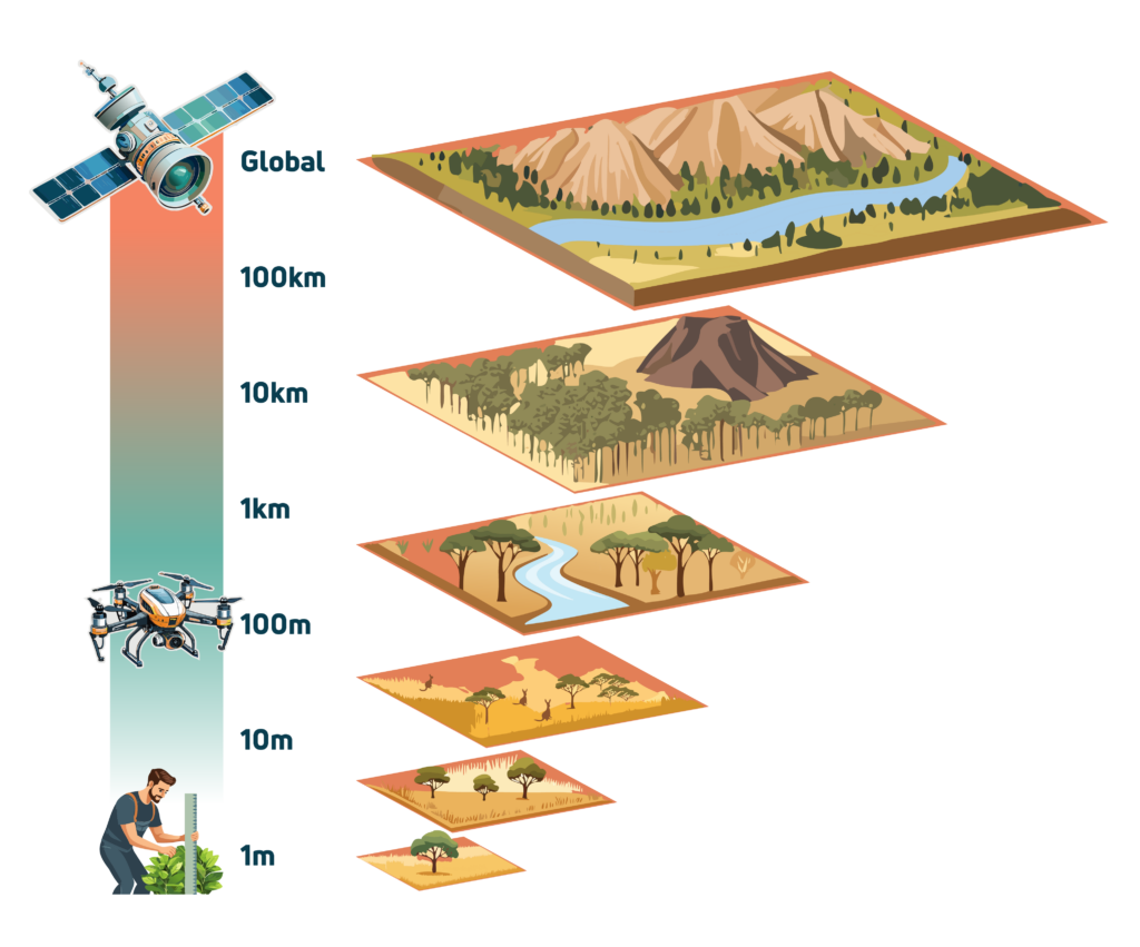
Unmanned aerial vehicles (UAVs), or drones, can fill the gap that emerges between distant remote-sensing and on-the-ground field observations, offering a cost-effective way to provide fine detail over a much larger area than could be easily covered on foot. For this reason, TERN has been steadily building capacity in drone-level monitoring through research collaborations and investment in drone technologies.
Dronescape
TERN’s Dronescape is a research infrastructure initiative developed in collaboration with the University of Adelaide and the University of Australia. The objective is to build a national drone-level remote-sensing ecological dataset that bridges field surveillance with satellite remote sensing. At the heart of this initiative is TERN’s land observatory which comprises more than 1000 one-hectare ecosystem surveillance field sites. Each of these ‘plots’ already generates a wealth of ground-based ecosystem surveillance data and specimen samples from systematic field surveys. Moreover, a subset of these – the SuperSites – also boast intensive field stations with automated instruments and sensors. The SuperSites also benefit from satellite remote sensing data collection.
Through Dronescape, two drones – an optical imagery drone and a LiDAR drone – are deployed at each TERN land observatory field site, enabling collection of low-altitude remote sensing data in the form of RGB images, multispectral images and LiDAR data. When combined with the existing data streams for each site, this adds a crucial layer of information, offering a more comprehensive understanding of spatio-temporal dynamics, biodiversity, species distribution, vegetation composition, canopy architecture, phenology, and more.
So far, Dronescape researchers have deployed drones and collected data at 271 field sites as they steadily work through the entire TERN land observatory. That’s just one part of the equation. The other challenge has to do with the data itself.
Drones gather a lot of heterogeneous data. Much of this heterogeneity is informative as it comes from the variability in terrain and vegetation both within and between ecosystems. But some data heterogeneity is simply noise or error. To get accurate observations and generate robust, informative datasets, you need to disentangle the two. That’s why Dronescape data specialists are developing robust protocols to standardise drone data collection and processing.
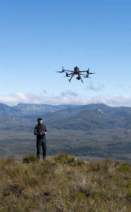
Image Left: Scientist piloting drone (credit Arko Lucieer, UTAS)

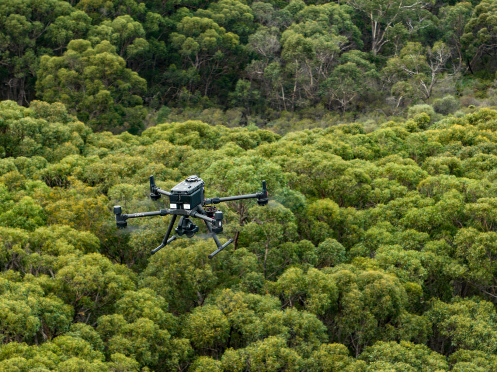
Above Left: Drone equipped with LiDAR sensor; Right: TERN drone mapping vegetation.
Video below: UAV LiDAR data collection at TERN’s Litchfield Savanna SuperSite (credit: Kim Calders)
A changing (technology) landscape
Remarkable developments in drone, sensor and computing technologies in recent years have expanded the usefulness of drones in ecological research, but there are more opportunities to explore. Drone batteries, for example, have improved substantially but battery life still limits flight time. In fact, flight duration for small remote-sensing drones used in ecological research rarely exceeds 25-30 minutes on average. Currently, remote sensing via drone requires on-site personnel for piloting the drones or monitoring pre-programmed flight. As it’s labour intensive and involves travel to remote locations, this is difficult to scale up for high-frequency, long-term monitoring.
Drone-in-a-box
As the name suggests, a Drone-in-a-Box (DiaB) involves a drone housed in a box. But this is no ordinary box: it’s a weatherproof shelter and charging station with internet connectivity which also serves as a launch/landing pad. The box itself is powered via grid electricity, where available, or via solar battery. When the drone is ready for flight, the box opens to enable the drone to easily take-off. When it returns after a flight, the box closes over the drone. Then, while the drone is in dock, DiaB systems upload data via satellite, recharge the drone and keep it safe in temperature-controlled conditions.
DiaB technology has only been around a few years but is already used routinely in the mining industry, explains Associate Professor Steven Micklethwaite, Director of the Drones Collaborative Research Platform at the University of Queensland. He believes DiaB shows great promise for environmental monitoring. “The advantage is extremely high resolution, high frequency monitoring and at multiple sites all at once.”
He explains that a DiaB unit could be permanently setup at a field surveillance site, such as a TERN SuperSite. The drones are fully autonomous, but due to aviation regulations must be piloted or have pre-programmed flights actively monitored. However, this can be done remotely enabling frequent data collection without having to be at the site in person.
“At the moment we can travel to some of these sites twice a year around the country, but DiaB could do it twice a day.”

If DiaB systems are set up at multiple environmental surveillance sites, someone sitting in a research lab in Brisbane or Adelaide could easily collect drone-level data in the Pilbara, the Daintree, and the Tasmanian Wilderness, all in the same morning. The resulting data could be quickly uploaded and processed while the drones recharge, and they could be deployed again the same day. This would potentially generate large datasets that provide useful ecosystem insights at a very high frequency.
Current DiaB units, such as those used in mining, use conventional, well-tested drones that are quite robust, says Steve. This bodes well for their use at remote environmental field sites in a variety of climates, as does the option to use solar power. They also have small-scale weather station capabilities to assess flight conditions, as well as a 360-degree camera for detecting potential collisions.
For data collection, DiaB systems currently incorporate a digital RGB camera with thermal imaging capabilities. It’s not the extensive sensor suite presently used by Dronescape, but it would readily provide a wealth of informative visual data, says Steve, noting that TERN is very familiar with processing visual data and has existing workflows that could easily handle this and turn it into useful data products. Meanwhile, he is confident that as DiaB technology continues to advance over the next two years, the range of sensors is going to multiply. This offers a unique window of opportunity for TERN and the UQ Drones Collaborative Research Program to do some critical groundwork (or aerial work, in this case).
“The interesting thing here is that drone technology is moving so quickly there’s a strategic advantage to implementing Drone-in-a-Box units at some of TERN’s SuperSites,” he says. By doing this sooner rather than later, scientists and engineers can get a better understanding of how DiaB can be applied to ecosystem monitoring, assess its reliability, and develop robust methods of data collection and ongoing maintenance.
“Getting involved with the DiaB technology now will mean we’re well positioned to use it in the very near future.”