About
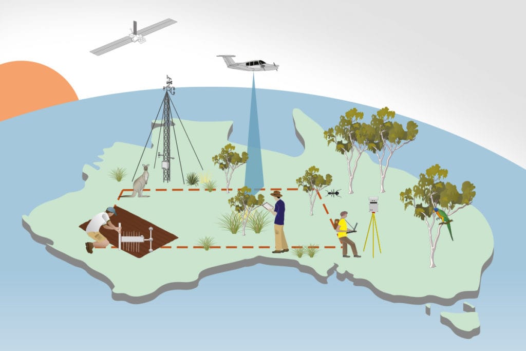
TERN measures key terrestrial ecosystem attributes over time from continental scale to field sites at hundreds of representative locations and openly provides environmental monitoring and assessment model-ready data that enable those undertaking environment and ecology research to detect and interpret changes in ecosystems.
We deliver quality environmental monitoring and assessment data, tools and expertise to researchers working on environment and ecology research, enabling a deeper understanding of Australia’s environment and its management for sustainable social and economic benefit.
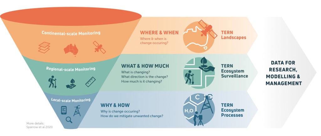
TERN Australia's multi-scale ecosystem observatory & environmental science research
TERN Landscapes
Based on remote sensing techniques, TERN provides spatial data products at regional and continental scales of land, terrain and soil attributes to characterise and monitor Australian ecosystems over time.

TERN Ecosystem
Surveillance
TERN’s plot-based field monitoring capability tracks the direction and magnitude of change in Australia’s environments over time through sampling and surveying flora, soil and some invertebrates.

TERN Ecosystem
Processes
TERN’s ecological research & ecosystem reference sites, located in key Australian biomes, combine time series data streams from micro-meteorological instruments with observations on flora and fauna to provide insights into ecosystem processes.

TERN's Vision & Mission
TERN’s Vision
TERN advances ecosystem science and contributes to sustainable management of Australia’s
environment.
TERN’s Mission
TERN is Australia’s ecosystem monitoring network. We build relationships and infrastructure to enable long-term, standardised collection of data and samples from across the continent. We store and openly share these resources, such as our environmental monitoring and assessment data, to support terrestrial and coastal ecosystem science and environmental management. TERN infrastructure, skills, data and samples are crucial to protecting Australia’s biodiversity and achieving a net zero future.
TERN's Principles
- TERN supports research leadership in terrestrial and coastal environmental monitoring and modelling for long-term national benefit.
- TERN’s fundamental purpose is to provide long-term data from its environmental monitoring and assessment infrastructure for the use of researchers in academia, industry and government
- TERN research infrastructure and data provide a service to researchers – TERN does not fund research projects.
- TERN provides foundational data and information products useful to researchers.
- TERN’s activities will support researchers’ priorities for fundamental ecosystem science and thereby the priorities of its funders.
Environmental monitoring and ecological research is designed to:
- measure parameters operating at vastly differing scales of space and time;
- enable concurrent assessment at multiple scales; and
- support upscaling and downscaling for modelling and prediction
- TERN’s work is directed towards the long-term preservation of time series data derived from monitoring, evaluating, modelling and predicting the status and trajectory of Australia’s ecosystems.
- TERN’s data and information products will integrate with monitoring conducted by related agencies.
TERN’s data and information products must be useful to and efficiently available for land management and policy-maker stakeholders, through whom learnings from research might achieve impact.
TERN educates the current and next generation of ecologists in how to use TERN tools and data so that they may better understand complex ecological systems and their associated changes and apply this integrated knowledge to societal needs
TERN engages with industry and raises awareness with national and international collaborators and
end users of research to ensure optimal utilisation of its research infrastructure and products.
TERN provides support to a new direction in knowledge creation related to the Australian environment, based on Aboriginal and Torres Strait Islander-led approaches to understanding and managing Land and Sea Country.
TERN’s standardised monitoring protocols, quality assured data systems and data exchange standards underpin environmental accounting and market schemes such as biodiversity and carbon offsets
Science Questions
TERN’s field observatory as well as the environment and ecology research data collection are shaped by the science questions pursued by Australian environmental science researchers.
- How are our ecosystems responding to environmental pressures?
- How might positive trends be enhanced and negative consequences managed?
- How is our environment likely to alter in the future, for example in relation to a different rate of change in climate?
- How are significant environmental assets – soils, carbon stocks, water, vegetation and biodiversity – responding to such changes and to their management?
- How resilient are the ecosystem services upon which our society and many of our industries depend, such as soil health, nutrient cycling, fire mitigation, provision of clean water, crop pollination, carbon sequestration and the effect on disease transmission?