News

Essential environmental data rise from the ashes

Automated sensors and detailed field surveys give scientists an unprecedented understanding of post-fire recovery and resilience of the Australian environment. While our country reels from early and extensive bushfires, data from last summer has been collected in Tasmania and is facilitating vital new science.

In January 2019, TERN’s highly instrumented, long-term ecological research site in Tasmania’s Huon Valley was severely burnt.  Fire consumed much of the understorey and scorched crowns of the eucalypt and blackwood overstorey.

The 80m tall monitoring tower survived the inferno, but a large amount of NCRIS-enabled TERN monitoring infrastructure was destroyed.  Soil sensors, bio-acoustic recorders, dataloggers, power and communication cables, either melted or irreparable. The nearby iconic Tahune Airwalk, almost completly ruined.

Fire damage at the Warra site from January 2019 illustrating the variation in the severity of crown scorching, the complete consumption of the ground layer vegetation and the destruction of sensitive monitoring equipment (images courtesy of Tim Wardlaw and Sustainable Timber Tasmania)
Rare dataset facilitating new carbon science

Thanks to massive efforts by TERN and site partners, Sustainable Timber Tasmania, Tasmania Parks and Wildlife Service and the University of Tasmania, the site was quickly made safe and most of the equipment reinstalled.  By Winter 2019, scientists like UTAS’s Dr Tim Wardlaw, were back at TERN’s Warra Tall Eucalypt SuperSite conducting post-fire research to assess fire impacts and ecosystem recovery.

“We now have a quality time-series dataset on the exchanges of water and carbon from the site’s flux tower before, during and after the fire event, which was the first in this forest since 1898!

Such data are very rare globally and may challenge some of our assumptions about carbon losses during fires.”

Analyses of the data indicate that there were several spikes in atmospheric concentrations of CO2 leading up to the fire and that around 10 tonnes CO2 per hectare was lost within a few hours during the passage of the fire.  That is about the same amount of CO2 that almost two homes emit in a year. Work continues and will be published soon…

UTAS’s Dr Tim Wardlaw at TERN’s Warra Tall Eucalypt SuperSite conducting post-fire research to assess fire impacts and ecosystem recovery
Detailed on-ground field surveys and sample collection

In late November 2019, TERN’s Ecosystem Surveillance team joined Tim at the Warra site to conduct detailed vegetation and soil monitoring.  Scattered in and around the Warra SuperSite are four one-hectare monitoring plots.  Baseline data at the plots were collected in 2012 and since then have been used in studies that are, for example, improving bushfire behaviour models for Tasmanian wet forests and predicting how forests will respond to global change and forestry management.

The field team used TERN’s AusPlots Forests Survey Protocols (Field Survey Apps) to collect extensive information on soils, vegetation structure and composition, alongside information on species occurrence, community composition and assemblage distributional patterns across the landscape.  They also collected hundreds of plant and soil samples that will be identified by experts and stored in herbaria and TERN’s open-access sample library.

Dr Wardlaw says that the on-ground data and samples collected at Warra will allow researchers to better understand post-fire ecosystem responses from all angles.

“When combined with the TERN Ecosystem Processes time-series data on water and carbon exchanges, it’s an immensely valuable dataset for understanding the functioning and resilience of Australian ecosystem to fire.”

Nikki Francis (left) and Tamara Potter (right) from TERN’s Ecosystem Surveillance team joined Tim Wardlaw at the Warra site to conduct detailed vegetation and soil monitoring in late November 2019
TERN facilitated science to be on show at rebuilt Tahune Airwalk

Another exciting new development at TERN’s Warra SuperSite is a collaboration with the Tahune Airwalk to incorporate the science from the site into the popular tourist attraction’s “Bluestone” interpretation centre—a beautiful stone building on the site of the Airwalk cafe and reception centre, which thankfully escaped the fire. Dr Wardlaw and his team will chronicle the development of the fire from ignition to just after the passage of the fire through the site as recorded by instruments at the TERN site.

“When the Airwalk re-opens in 2020, we hope to give visitors a new and different experience by telling the story of the ecology of the tall wet eucalypt forests and their utter dependence on fire for their continued existence.

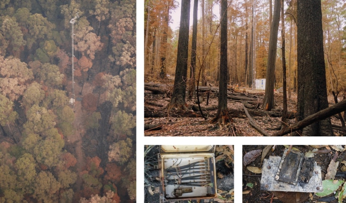
Time-lapse imagery captured over the fire period by phenocams installed on the site’s flux tower, will capture the attention of café visitors and lure them to the Bluestone Shelter where the main science interpretation displays will be.”

Dr Wardlaw says that eventually the Bluestone Shelter interpretation centre will use real-time data from the site’s instruments to tell a story of “how the forest is feeling” together with stories about the post-fire recovery of the forest and its sensitivity to warmer temperatures and more generally about the ecology of the wet eucalypt forests based on the knowledge we have gained from research using NCRIS-enables research infrastructure at TERN’s Warra SuperSite.

Postscript

TERN would like to acknowledge the ongoing efforts of fire authorities, volunteers and communities working to control the current bushfires across Australia, and commend those working to ensure the safety of our regional communities, and protect our precious ecosystems. 

In late November 2019, TERN’s Ecosystem Surveillance team joined UTAS and Sustainable Timber Tasmania at TERN Warra SuperSite to collect extensive information on soils, vegetation structure and composition, alongside information on species occurrence, community composition and assemblage distributional patterns across the landscape

Share Article