
High-resolution (30m), high-frequency (monthly), continuous (no gaps due to clouds) actual evapotranspiration data are now freely available for download from TERN. These world-leading satellite-derived data promote accurate water balance modelling for any catchment or groundwater system in Australia.
The dynamics of water use from all vegetation communities, including ‘biodiversity hotspots’ such as groundwater dependent ecosystems, can be monitored through droughts and floods. They are essential information for environmental policy-makers and managers, the Australian irrigation industry, and will help promote enhanced water resource management and ensure the nation’s food security.
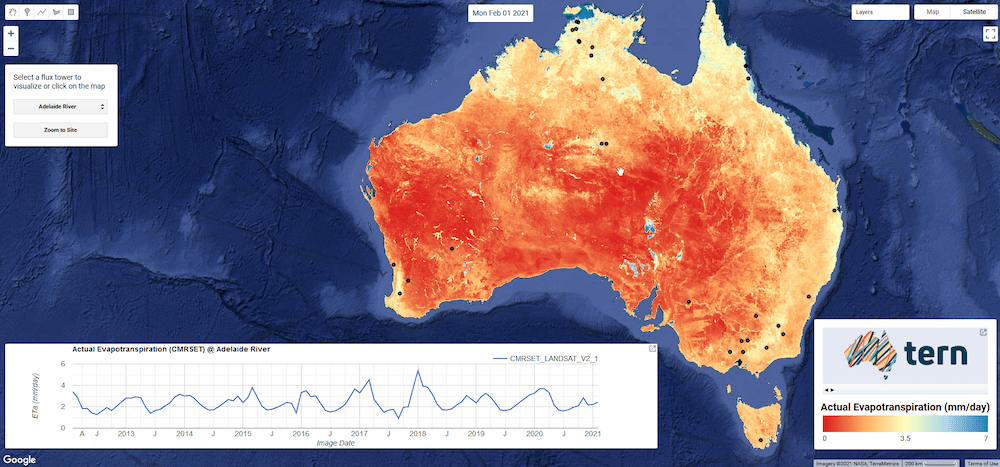
TERN’s AET data provides Australia-wide coverage at a 30m resolution every month.
Like many other parts of the world, water availability in much of Australia is scant. The largest consumptive component of our water balance is the water that’s removed from the land-surface and plants by evaporation and transpiration—called actual evapotranspiration (AET).
Accurate AET information is vital for informed water and environmental research, decision-making and resource management. Moreover, because 70% of Australia’s available freshwater resources is used for crop and pasture irrigation, AET data are essential for better irrigation monitoring and management.
Dowload AET Data
Improved water balance modelling and understanding of ecosystem water requirements
TERN’s high-resolution, monthly and accurate AET estimates for the entire Australian continent will allow precise water balance modelling for any catchment or groundwater system in Australia, says Dr Tim McVicar, a spatial eco-hydrologist at CSIRO with 30 years research experience in the use of time series remote sensing data.
“These landmark AET data from TERN will support improved water use efficiency in the irrigation sector, helping ensure Australia’s future food security and potentially making water savings available as environmental flows.
Additionally, the data provide much needed information on the water needs of groundwater dependent ecosystems allowing for enhanced management of these small but critical biodiversity hotspots.”
Dr Tim McVicar, CSIRO Land and Water
TERN’s new AET dataset has been produced in collaboration with Dr McVicar and other world-leading researchers and software engineers at CSIRO Land and Water.
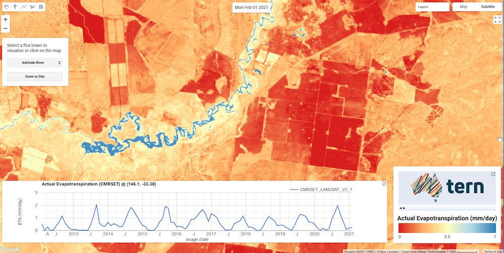
TERN AET data from the Lachlan River catchment in New South Wales
Blending the best data sources available
The new TERN AET dataset has been produced using the CMRSET (CSIRO MODIS ReScaled EvapoTranspiration) algorithm, which uses satellite-derived indices of reflectance to estimate AET from potential evapotranspiration (PET). PET is calculated using daily gridded meteorological data from the Bureau of Meteorology (BoM).
The CMRSET AET model has been calibration and validated using data collected from the TERN OzFlux network. It has also been validated at catchments using gridded meteorological data and streamflow data made available by BoM. Additional validation shows the TERN AET data are as accurate as other global AET datasets (having at best 500m resolution) yet having much higher spatial resolution (30m).
Where there are gaps due to cloud in high-resolution / low-frequency satellite data (e.g., Landsat and Sentinel-2) blending their CMRSET AET estimates with low-resolution / high-frequency CMRSET AET estimates (e.g., MODIS and VIIRS) ensures there are no gaps due to cloud: the data are “good to go”.
It is this amalgamation of data from multiple sources that results in AET data that are high-resolution (30m), high-frequency (monthly), continuous (no gaps due to cloud) and accurate—all ideal characteristics when calculating the water balance for a wetland, paddock, river reach, irrigation area, landscape or catchment.
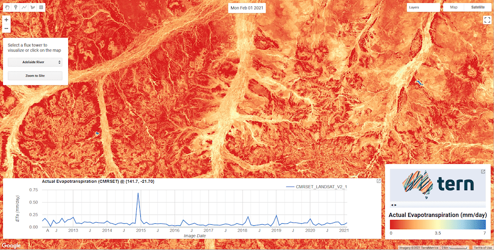
TERN AET data showing a stream network in central Queensland
Raw data plus Google Earth Engine access
The TERN AET CMRSET dataset is now openly available for download via the TERN Data Discovery Portal. TERN and CSIRO have also teamed up with Google to make the dataset also available through Google Earth Engine.
Google’s enormous cloud computing power, combined with more than 40 years of global satellite imagery and tools and methods housed in thousands of computers in Google’s data centres, mean that data users now have the knowledge and resources they need to track water use dynamics from the paddock-to-continental scales using Google Earth Engine, Google Earth and Google Maps.
Jamie Vleeshouwer, also of CSIRO, is a key member of the team who worked behind the scenes with Google to make these advancements possible.
“Users no longer have to worry about data preparation or finding storage for terabytes of data, which can be up to 80% of people’s time in projects and be too difficult for personal laptops to handle. We accessed over 75 TB of Landsat imagery on Google Earth Engine to produce the monthly data from Feb 2012 onwards.
“Google Earth Engine’s near-real-time processing means that common tasks in the Grid now execute in under a second, with more complicated tasks taking about five seconds.
It’s also great for collaboration and communication as scripts and imagery can easily be saved and shared without shipping around too much data.”
Jamie Vleeshouwer, CSIRO
The AET dataset is not the first TERN delivered product to be made available via Google Earth Engine. TERN’s Soil and Landscape Grid of Australia (The Grid) and some remotely sensed vegetation monitoring products, including ground cover data, have been available via Google Earth Engine for almost a decade.
Combined with data already freely available via The Grid, the TERN Data Discovery Portal and CSIRO’s Data Access Portal, access via Google Earth Engine provides unprecedented capability in the use of TERN data for all sorts of agricultural, environmental management, conservation and landscape science projects.
- Details of the CMRSET algorithm and its independent validation are provided in: Guerschman, J.P., McVicar, T.R., Vleeshouwer, J., Van Niel, T.G., Peña-Arancibia, J.L. and Chen, Y. (2022) Estimating actual evapotranspiration at field-to-continent scales by calibrating the CMRSET algorithm with MODIS, VIIRS, Landsat and Sentinel-2 data. Journal of Hydrology. 605, 127318, doi:10.1016/j.jhydrol.2021.127318
- Details of the TERN CMRSET AET V2.2 data product generation are provided in: McVicar, T.R., Vleeshouwer, J., Van Niel, T.G., Guerschman, J.P., Peña-Arancibia, J.L. and Stenson, M.P. (2022) Generating a multi-decade gap-free high-resolution monthly actual evapotranspiration dataset for Australia using Landsat, MODIS and VIIRS data in the Google Earth Engine platform: Development and use cases. Journal of Hydrology (In Preparation).
- To access the AET data via Google Earth Engine please complete Google’s sign up process. A dataset catalogue record of TERN's AET data on Google Earth Engine can be openly viewed here.
- Access the data via TERN’s Data Discovery Portal
- Explore CMRSET Code examples for users
Download AET Data via Google Earth Engine
Article updated February 2022