For the first time, long-term measurements of coastal wetland elevation are underway in Tasmania. TERN Australia’s national coastal wetland monitoring network OzSET has expanded to Tasmania, with the first Rod Surface Elevation Table–Marker Horizon (RSET-MH) sites now established in the Derwent Estuary and Pitt Water Estuary. TERN’s OzSET team provided technical training in the installation in partnership with the Derwent Estuary Program, NRM South, Clarence Council and the University of Tasmania. These sites will provide the first long-term measurements of surface elevation change in Tasmanian saltmarsh, providing critical data to understanding how wetlands respond to sea-level rise and changing environmental conditions.
By Madeline Goddard
Coastal wetlands occupy a narrow zone in the tidal frame, meaning even small changes in elevation can have significant ecological consequences. By measuring millimetre-scale changes in elevation and sediment accretion over time, OzSET instruments provide insights into whether wetlands are keeping pace with sea-level rise.
This work comes at a critical time. The recent Australia’s Environment Report 2025 highlights ongoing pressures on Australia’s coastal environments, including rising sea levels, increasing temperatures and shifting ecological conditions. Tasmania has not escaped these pressures and the saltmarsh ecosystems that dominate the low-energy intertidal zone, have limited long-term data available to understand how these systems are responding. Establishing a baseline and surface elevation trend through OzSET instruments provide a critical foundation to track change, inform management and support climate adaptation in Tasmanian coastal wetlands.
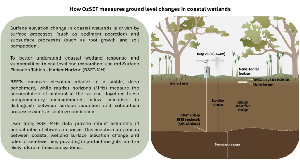
The RSET-MH method was developed by the USGS and is considered the ‘global standard’ for coastal wetland monitoring vulnerability to sea-level rise (Webb et al. 2013)
Tasmania presents a unique monitoring opportunity. Coastal wetlands in the State are dominated by biodiverse saltmarsh ecosystems, which are highly valued for their biodiversity and ecosystem services but remain underrepresented in national elevation monitoring datasets. These systems support high natural values, including rare plant species and the endemic Tasmanian Saltmarsh Looper Moth (Scopula achroa), listed as vulnerable under the Tasmanian Threatened Species Protection Act 1995.
As the climate warms and sea-levels rise, coastal ecosystems are expected to shift. Mangroves are expanding poleward in many regions, gradually encroaching into saltmarsh environments. In Australia, Avicennia marina is found as far south as Corner Inlet in Victoria. Tasmania, however, remains mangrove-free.
This absence reflects more than just temperature limits. While warming conditions may increase suitability of Tasmania’s coasts for mangrove establishment, dispersal barriers such as Bass Strait and local environmental conditions continue to limit establishment. At the same time, Tasmanian estuaries have already experienced ecological change through introduced species, including saltmarsh weeds such as Spartina anglica and the expansion of Juncus acutus, which is increasingly impacting saltmarshes in the east and north of the State. Changes in rainfall and runoff, particularly in eastern Tasmania, may further influence saltmarsh extent and condition. These pressures are compounded by land modification, such as tidal restriction, infilling and coastal development, which can limit the natural landward migration of the already threatened temperate saltmarsh ecological community.
Understanding whether these coastal ecotones may shift in the future and how Tasmanian wetlands will respond to sea-level rise, remains an open question. The establishment of long-term monitoring sites provides a foundation for detecting these changes over time.
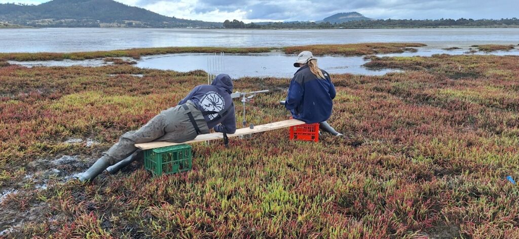
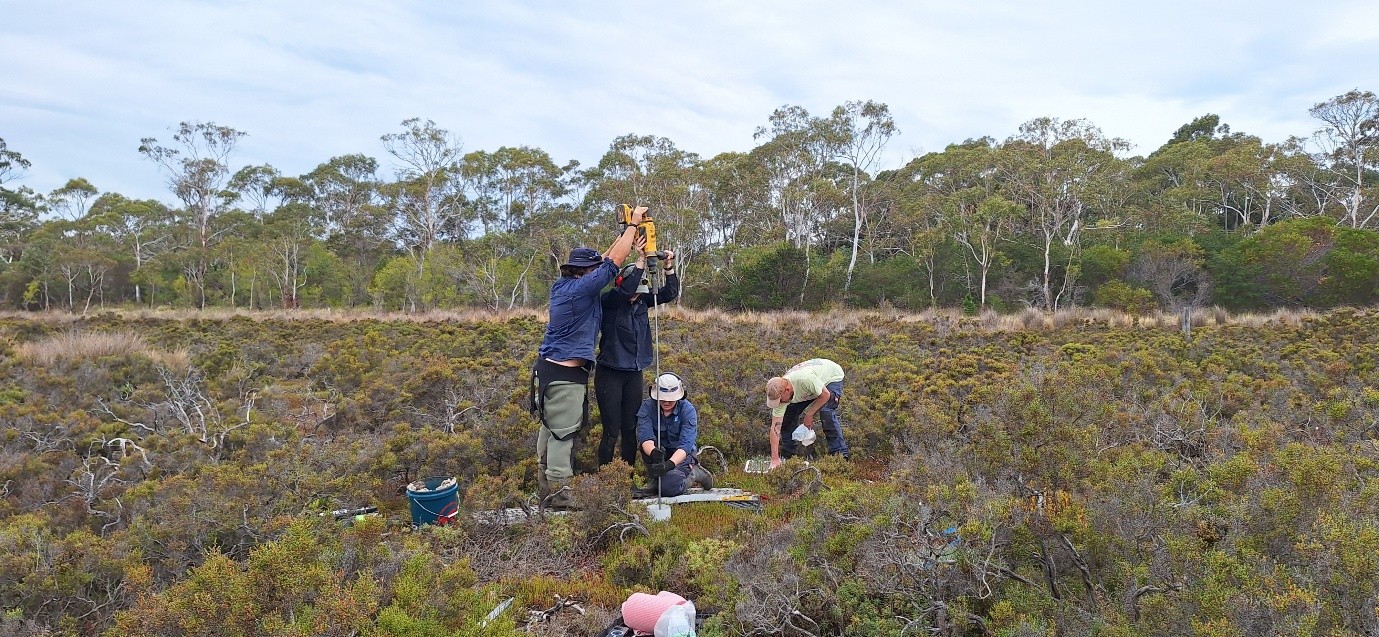
Recently, Tasmania’s first Rod Surface Elevation Tables-Marker Horizon sites (RSET-MH) were established at the Derwent Estuary and Pitt Water Estuary in the State’s southeast. TERN’s OzSET team provided technical training for the installation in partnership with the Derwent Estuary Program, NRM South, Clarence Council and the University of Tasmania.
These RSET-MH sites will enable scientists to closely monitor changes in elevation and sediment accretion in this region. Moreover, the Pitt Water Estuary site is situated in a blue carbon restoration area in the Pitt Water-Orielton Lagoon, providing an opportunity to track how restoration efforts influence surface elevation dynamics and long-term resilience.
The establishment of these sites also represents an important milestone for TERN OzSET, completing coverage across all coastal Australian states and territories and hence, building a coordinated, nationally consistent approach to coastal wetland monitoring, supporting research, managementand climate adaptation planning.
Feature image: Installation of an RSET at Dorans Road saltmarsh in Lauderdale. From left to right: Phillip Pennisi, Amelia Jensen, Ellie Green, Joshua Glen (image provided by Madeline Goddard)