Cyanobacterial crusts on soil surfaces promote landscape stabilisation and carbon and nitrogen fixation. This makes them important ‘ecosystem engineers’ as they cause changes in soil surface conditions that affect habitats for other organisms. A new collaborative project between Loughborough University in the UK and TERN’s AusPlots facility is leveraging on the technology delivered by AusPlots’ AuScribe Field Data App to develop a new app that can be used to quantify cyanobacterial crust cover in the field by users with minimal training.
 |
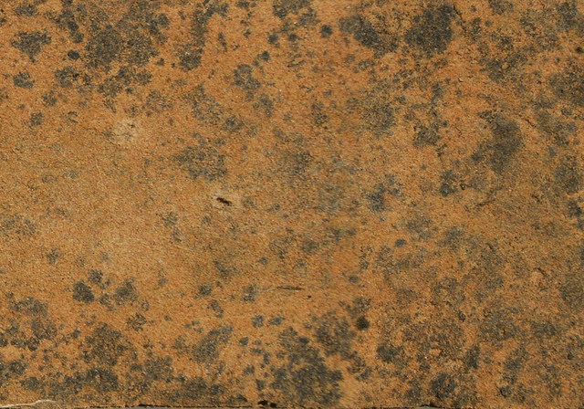
| Micro-canyonlands formed by cyanobacterial soil crusts (image courtesy of flickr.com/photos/archesnps/ CC BY 2.0) |
For land managers, an important indicator of soil erodibility is the percentage cover of cyanobacteria due to the crusts’ ability to hold soil together and stabilise landscapes. Cyanobacteria are used to inoculate soils in China, the USA and Middle East to try and mitigate wind and water erosion. They also play an important role in stabilising the extensive grasslands of southern Africa and there is a particular interest from national park managers, such as in the Kalahari National Park, in the impact of wildfire on surface crusts and the persistence of fire-damage to the soil ecosystem.
Despite their ecological importance, there is currently no simple, non-invasive way to measure cyanobacteria cover and monitor changes following management actions, including spray-inoculation. To quantify the presence of cyanobacteria in the field the soil has to be disturbed (e.g. using a probe) or destroyed (e.g. for biological extraction). This is undesirable when the subject of interest is how well the cyanobacteria bind and protect a soil surface. The development of the new app is set to change this.
The collaboration will develop an app that manipulates images of the soil surface captured on smartphones and tablets to produce an accurate map and indication of percentage cover of cyanobacteria.
Using lab-based crust growth experiments conducted by Griffith University in Queensland, researchers from Loughborough and Reading University in the UK have developed a method for mapping cyanobacterial cover in digital images. An algorithm identifies the distinctive absorption of light by cyanobacterial photosynthesis, showing where biological crusts are present, both in field photos and remotely-sensed satellite images. This method will be combined with AusPlots’ technical expertise and experience in the development of apps for ecological fieldwork. The project will produce a new stand-alone app and also investigate the possibility of incorporating the crust-imaging technology into AusPlots’ AuScribe app.
Professor Joanna Bullard of Loughborough University is part of the partnership and says that despite the important role cyanobacteria crusts play in stabilising the soil against wind erosion and also storage of nutrients, they are difficult to measure with the naked eye and so often overlooked in rangeland surveys.
“We have been developing ways of measuring crust cover for research purposes and are keen to ensure that these methods are tested and become available for land managers,” says Joanna.
“We are very excited to be collaborating with AusPlots to explore the potential for incorporating our method into the field survey app especially because the AusPlots standardised methodology is so widely used across Australia.”
“Users of the AusPlots methodology will benefit from being able to measure an additional important variable, and we will benefit from learning more about how cyanobacteria cover varies across the country.”
Rangeland areas of Australia and around the world—where cyanobacterial crusts have their biggest impact on soils with low natural organic content, such as semi-arid, sandy soils—are vast and often very remote meaning that the mapping of vegetation and soil condition is often conducted by people without specialist expertise in soil science such as rangeland managers, farmers, or national park rangers. The main impact of developing an app that exploits the already in-built technical capabilities of smartphones is that it opens access to vital, detailed information about soil condition without requiring expensive, specialist equipment.
The Director of AusPlots, Ben Sparrow, is excited about the benefits the new app is set to bring to people working in rangelands worldwide.
“It’s great to see that our products are being noticed and recognised internationally,” says Ben. “Our AuScribe app development team, led by Andrew Tokmakoff, has worked hard to develop an app that is world class, so it’s really great that our hard work will not only help field ecologists here in Australia, but may also become of assistance to land managers everywhere.”
A prototype app will be completed in the next few months, during which time the app will be designed and tested using laboratory-grown cyanobacteria. Once tested in the lab, the team plans to test the new app during fieldwork in Australia (in July-August) and southern Africa (in September as part of a UK Natural Environment Research Council project and Loughborough University funded research). Keep an eye out in upcoming editions of TERN eNewsletter for more updates on field survey apps.
 | 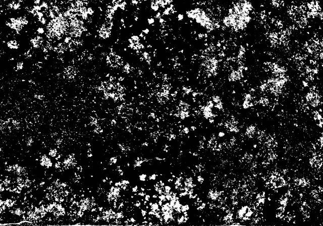 |
Cyanobacteria and algal cover on a soil surface (left) and the results of the algorithm and threshold detection method which make it possible to determine that 15% of the surface shown has a cyanobacterial cover (right) | |
Published in TERN newsletter June 2015
