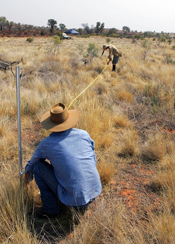
Rick Flitton and Emrys Leitch, members of the AusPlots Northern Territory Field Team, establishing a rangelands monitoring quadrat in the Finke Bioregion, Northern Territory.
One of the major impediments to continental-scale assessments of ecosystem trends in Australia is the lack of comparability of monitoring data across time and space, caused by the use of incompatible survey methods. Researchers funded through the Terrestrial Ecosystem Research Network (TERN) AusPlots program have now produced a solution to this problem that can be used to monitor rangeland ecosystems, which cover approximately 80% of the Australian continent.
Close working relationships with collaborators from many different states and agencies have been key to the success of this project, reports Ben Sparrow, who is based at the University of Adelaide. ‛And the result of that close collaboration during the development phase can now be seen in the rapid adoption of the methodology. Within the next couple of months, field survey teams in NT, SA and NSW will be using the methodology and its associated app to collect data more efficiently, often in conjunction with their own established monitoring programs.‛ AusPlots is a member of TERN’s Multi-Scale Plot Network, which aims to facilitate description of the rate, magnitude and direction of change in Australian ecosystems and biodiversity more comprehensively than ever before.
Federal government agencies concerned with monitoring and reporting national trends in ecosystem condition are understandably also interested in a methodology that is compatible with historically-collected datasets and permits seamless comparison of field survey results across states. Field teams from state and territory departments collaborating with the federal Department of Agriculture, Fisheries and Forestry on the ‛Ground Cover Monitoring for Australia‛ project are now looking to incorporate a customised version of the AusPlots Rangelands app into their standard national survey protocols. The data generated will be automatically uploaded and made publicly available via the ÆKOS data portal, being developed by TERN’s Eco-informatics Facility. ÆKOS is a groundbreaking web-based portal that will store the data and use new semantic techniques to provide greater and deeper data discovery.
‛Using the app on a tablet while you’re standing right there in the field cuts down on the potential for errors in method and data entry,‛ explains Ben. ‛And the data can then be uploaded to the server as soon as you have a network connection. These kinds of simple efficiencies can be really important in the context of long-term monitoring programs, and significantly cut down on time spent entering raw data.’
As a consequence, a wide range of NGOs including environmental organisations, environmental consultancies, pastoral and mining companies have already expressed interest in using the method to monitor environmental change on lands that they are responsible for managing.
The AusPlots Rangelands Methods Manual and app will be available for public download from the TERN website very soon – keep an eye on the TERN e-Newsletter for details. For more information, email Ben Sparrow.
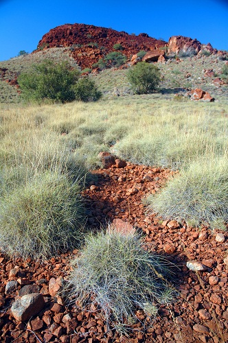
Widespread adoption of the AusPlots-Rangelands methodology (and its associated app) will enable national assessments of trends in Australia’s vast rangelands areas, including regions such as the Pilbara (pictured) and the Kimberley.
Published in TERN e-Newsletter June 2012.
