AusPlots is well on the way to establishing its planned network of about 1,000 permanent ecosystem observation, and vegetation and soil monitoring plots throughout the Australian rangelands.
AusPlots is one of three sub-facilities under the Multi-Scale Plot Network (MSPN) facility and is based at Adelaide University. It has two components: Rangelands (hosted at the University of Adelaide) and Forests (hosted at the University of Tasmania).
It is establishing a continental network of plots to monitor the most important ecosystems and landscapes, and to record baseline vegetation and soil data, and is being driven by key AusPlots staff such as Andrew White (AusPlots-Rangelands coordinator), Professor David Bowman (AusPlots-Forests leader), Sam Wood (AusPlots-Forests coordinator), Jeff Foulkes (AusPlots coordinator) and Ben Sparrow (survey manager).
Having a large number of plots covering the major ecosystems means that AusPlots will be able to collect coherent and compatible ecologically relevant data in a consistent manner. It will contribute information to the ecological, remote sensing and modelling research communities, from many of Australia’s most widespread ecological communities, some which have not been sampled thoroughly.
It will also provide enhanced biodiversity information to local, state and federal management agencies and other natural resource managers to assist them in making better management outcomes for their areas.
Plot surveys begin in the rangelands
Once the permanent monitoring plots have been established, AusPlots-Rangelands will undertake initial surveillance to provide valuable baseline biodiversity data. Doing this will allow us to monitor change in rangeland ecosystems in the future.
The rangelands team has been operational for just over a year. Under the guidance of its reference groups and other mentors, it has developed a survey methodology that all the rangelands jurisdictions (Western Australia, South Australia, Northern Territory, Queensland and New South Wales) will use. The methodology, which will shortly be submitted for publication to Austral Ecology, will contribute a wealth of data to the ecological, remote sensing and modelling research communities. For example, by collecting Leaf Area Index data, AusPlots will contribute to the validation of broader remote sensing activities, such as calibrating and validating maps of this parameter for the whole continent.
Plot-based surveillance has begun in the Northern Territory and South Australia, and negotiations about the location and numbers of sites, as well as contract finalisation, continue with the other jurisdictions.
The survey plots measure 100m x 100m. The use of different survey and sample collection components have been designed as modules, making it possible to implement one or more of the techniques. The team’s current focus is to provide an inventory of vegetation and soils.
The methods used include traditional descriptive and analytical components such as collecting and barcoding plant voucher specimens for herbarium identification and curation; using the point intercept method at 1,000 points across the plot to provide measures of vegetation cover and species details; and using soil cores or samples to describe soil attributes.
In addition to more traditional analysis AusPlots is also using progressive and innovative survey methods. For example, it is linking to remote sensing to help determine the amount of plant cover, collecting Leaf Area Index data, mid-infrared spectrometry analysis of soil samples to describe soil attributes, making leaf collections for DNA and isotope analyses, and collecting surface soil for metagenomic analysis.
AusPlots-Rangelands has also been working with the Australian Centre for Visual Technologies, a University of Adelaide research group that focuses on computer vision, to establish the best methodology for making photo surveys of field sites. AusPlots-Rangelands coordinator Andrew White said that, unlike traditional single-exposure photo points, the AusPlots method captured three-dimensional data, which could represent vegetation structure far better.
‘We’ve been conducting field experiments to determine the best parameters to characterise each site, criteria for camera equipment, and how to process photo data to produce panoramas and to extract useful data from the imagery,’ Andrew said.
‘Our next steps will be to recreate the structure and basal area of survey sites from photos, and to work on computing infrastructure to host and automate the process.’
The development of the biological data recording system (reported in the June newsletter), which allows instantaneous capture of field data on phones and other mobile devices, has been progressing well, with AusPlots’s collaborator Gaia Resources updating the technology with the assistance of the Atlas of Living Australia.
The updates improve the software by incorporating the results of extensive field trials, some of which Gaia Resources programmers took part in. The updates include streamlining the data collection and coding making them noticeably quicker to use.
‘We’re now smoothing out the automatic data uploading and synching capabilities, and working on setting up the AusPlots database, and synching that with the field devices,’ Andrew said.
A number of organisations including Indigenous groups, natural resource management bodies and non-government organisations (NGOs), as well as consultants, have expressed interest in incorporating the AusPlots method into their monitoring and inventory protocols. Training in the methodology is to be provided at Renmark in South Australia from December 5–9. Places are limited, so please register your interest by emailing AusPlots-Rangelands as soon as possible.
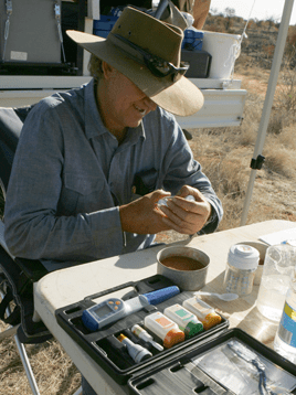 | 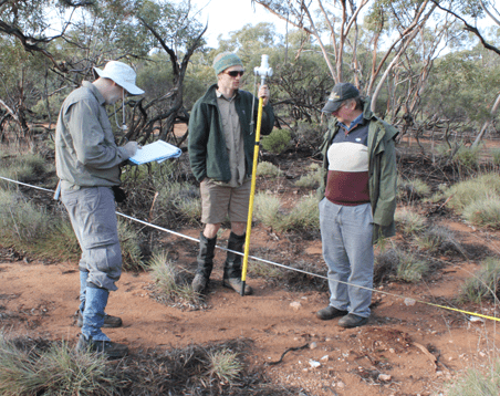 |
Testing soil samples in the field | Surveying vegetation cover along a transect |
Design of forest plots under way
September 2011 saw the start of the AusPlots-Forests project, which will run parallel to AusPlots-Rangelands and will deliver the first permanent plot network for monitoring the biodiversity, carbon stocks, soil resources and productivity of Australia’s forests at a continental scale. It is coordinated by the University of Tasmania and the Commonwealth Department of Agriculture, Fisheries and Forestry.
The team is exploring potential designs for the forest monitoring plot network. Because it cannot cover all of Australia’s forest types and disturbance regimes, it will focus on the highest priority forest and land-management types. AusPlots-Forests will provide national and international synthesis, and assessment of the baseline condition and the impact of management on the biodiversity, soils, forest productivity and carbon of these ecosystems. The data collected will be used to inform the sustainable management of Australia’s forest resources.
AusPlots-Forests coordinator Dr Sam Wood said the team was working out which existing forest-monitoring plots could be incorporated into the network.
‘Historically, forest-monitoring plot networks in Australia have been designed, implemented and managed by State forest agencies and research teams, and so they have focused on answering regional ecological or management-oriented questions,’ Sam said.
‘Recently, the University of Tasmania and the Department of Agriculture, Fisheries and Forestry collaborated to compile a subset of State forest inventory data, and now we’re investigating continental trends in forest growth and the biogeography of the forests grown for harvesting.
‘Guided by this experience, one of our first steps in the design of the plots and the network will be to assess the feasibility of including the existing plots in a continental forest plot network. If we can do this, we’ll be able to include the huge amount of historical data about these forests.’
International collaborations have done just this: established a framework for the re-measurement of existing forest plots using standardised measurement protocols. One example is RAINFOR, a framework that capitalises on historical datasets and ensures the consistent collection of data in the future.
‘This model is particularly attractive, because it allows for both continental and international comparisons of the biodiversity, productivity and carbon status of Australia’s forest estate,’ Sam said.
AusPlots-Forests is still in its development stage and will begin consultation with the wider forest ecology research community in late 2011. If you’re interested in being involved or would like more information, please contact Sam Wood or David Bowman.
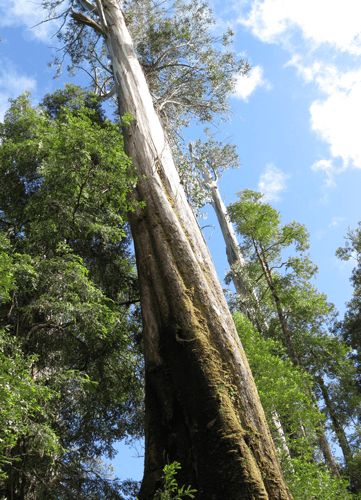
Eucalyptus regnans woodlands in the Styx Valley, Tasmania