Ecosystem data maps allow managers to craft strategies that ensure that our unique ecosystems and their services are not lost. Unfortunately, however, there is no consistent way of mapping ecosystems across nations and jurisdictions. Thankfully, this is set to change courtesy of TERN and the University of Adelaide who have remapped the characteristics of Australia’s ecosystems using nationally and globally consistent methods.
Imagine if Google Maps had an ‘ecosystem layer’. Land managers everywhere in the world would have globally consistent information on key ecosystem characteristics at their fingertips.
Differences in ecosystems from one continent to another could be compared, informing management strategies to assist biodiversity conservation, climate change impact studies and mitigation, ecosystem services assessments, and development planning.
Unfortunately, there is no globally consistent ‘ecosystem layer’, rather a raft of approaches that differ from nation to nation. In fact, here in Australia, progress is being made but each state or region still uses different ecosystem mapping methods.
This, however, is about to change, thanks to the efforts of a team of University of Adelaide researchers and TERN.
Australia’s ecosystems and ecological characteristics mapped
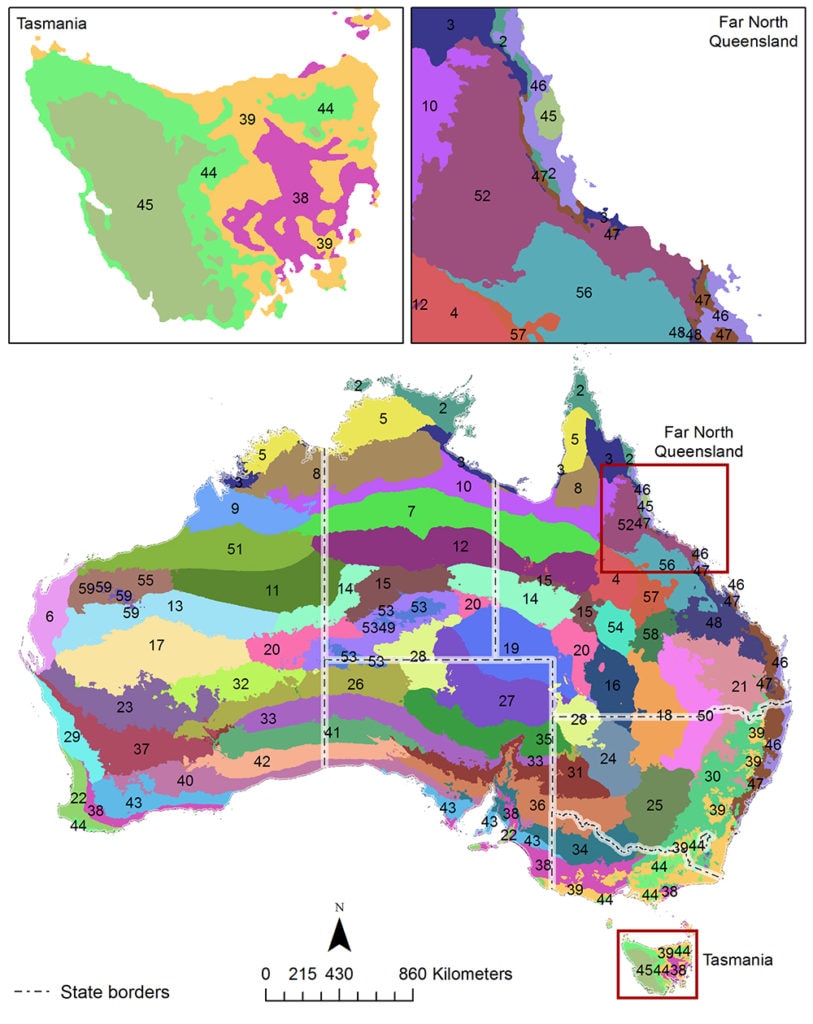
Australia’s ecological characteristics have been mapped using globally consistent methods, capturing the major factors driving ecosystem formation—macroclimate (above), lithology and landform—and vegetation structure
In June 2017, the Queensland government, with assistance from TERN, released Australia’s first comprehensive state-wide regional ecosystem maps, providing unparalleled detailed online information on the status of Queensland’s diverse native vegetation.
Other Australian jurisdictions have also produced detailed ecosystem maps, but there is currently no Australia-wide standardised map of ecological characteristics at management-appropriate scales.
The University of Adelaide and TERN’s Landscape Assessment capability have addressed this information gap by mapping the ecological characteristics for continental Australia using globally consistent methods.
The new maps capture the three major factors driving ecosystem formation—macroclimate, lithology and landform—with multiple spatial indicators. Vegetation structure has also been mapped and combined with the three indicators of ecosystem formation to produce ‘ecological facets’—distinctive and unique ecological units.
“The ultimate goal of this work was the production of the ecological facets digital map,” says Dr Ken Clarke of the University of Adelaide. “These ecological facets allow for a better understanding of the current range of biophysical variation within and across Australian ecosystems.”
“We anticipate, however, that for many applications the precursor spatial indicators will be more useful by themselves.”
“While this is not the officially approved approach for Australia, it does build on IBRA [Interim Biogeographic Regionalisation for Australia] and NVIS [National Vegetation Information System] data provided by the Australia Government Department of Environment and Energy [DoEE].”
Aligning Australia with global standards for ecosystem mapping
This work is part of a much bigger global project led by the Group on Earth Observations (GEO), a consortium of over 100 nations, including Australia, that seek to promote earth observation for for solving some of society’s most difficult problems.
“The opportunity emerged for us to work with GEO’s Global Earth Observation System of Systems [GEOSS], the US Geological Survey, DoEE’s ERIN [Environmental Resources Information Network] and TERN to contribute to a global effort to characterise ecosystems in a consist global way,” says Professor Megan Lewis of the University of Adelaide.
“The ecological facets dataset that we’ve produced is a first attempt at aligning Australia with global standards and providing essential and consistent insights into the characteristics of Australia’s ecosystems.”
“Our new method is more data-driven and transparent than current approaches in Australia and we hope that this will help the ecosystem science community to better understand it, use it, or adapt our methods to suit their needs.”
“From development planning and on-ground assessments of vegetation change through to facilitating future predictive environmental modelling, the suite of potential applications for these data is very diverse. We look forward to working with Australia’s environmental research and management communities as these exciting applications develop.”
- Click here to download the ‘GEOSS Ecosystem Mapping for Australia’ report (3MB) or view it below.
- Data on ecosystem formation (macroclimate, lithology and landform), vegetation structure and ecological facets are openly available via TERN’s Landscapes platform.
- For more information on this project please contact Dr Ken Clarke
- For more information on TERN’s Landscapes' continental-scale remote sensing monitoring, modelling and synthesis activities click here.