Detecting landscape change with drones – Fowler’s Gap UAV Campaign 01 from TERN Australia on Vimeo.
Ground, air and satellite data for more meaningful ecosystem information
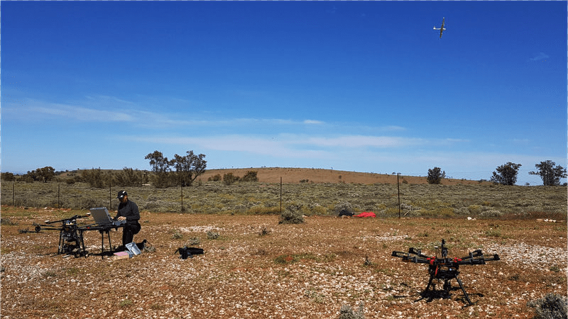
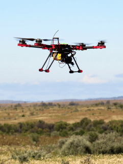
The UAVs used during the weeklong event—enabled by TERN AusCover’s collaborative network and well regarded extertise—ranged from your typical ‘off the shelf’ models, right through to those individually designed and constructed to carry a range of instruments. Over 30 instruments, including RGB cameras, multispectral, hyperspectral and thermal sensors and lidar, were carried on 17 airborne platforms.
TERN AusCover provided support for both ground and UAV operations, which also included measurements at the station’s six TERN AusPlots sites, whilst Airborne Research Australia provided a unique opportunity for concurrent and synergistic aircraft observations using a wide range of sensors. Riegl Laser Measurements Systems GmbH (Austria) also made one of their top-of-the-range airborne lidar units available to demonstrate a UAV compatible survey-grade sensor.Arko Lucieer (University of Tasmania) was one of the event organisers and says that UAVs capture imagery that enable scientists to create models and maps that provide information on a wide range of ecosystem variables.
“This landmark event enabled the simultaneous collection of data on the ground and from the air,” says Arko. “These sensors provide information at unprecedented spatial detail and the workshop clearly demonstrated capability for scaling up observations to support a range of broader applications.”
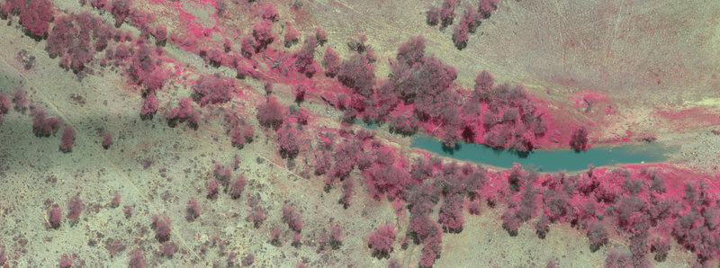
“Linking ground, air and satellite data leads to a much better understanding of the way satellites observe the Earth and how observations relate to ecologically meaningful properties of our ecosystems. Through this campaign, we haven’t just strengthened the research network and partnerships in Australia, we have also contributed knowledge to national and international efforts aimed at calibrating and validating satellite products from space agencies.”
 |  |
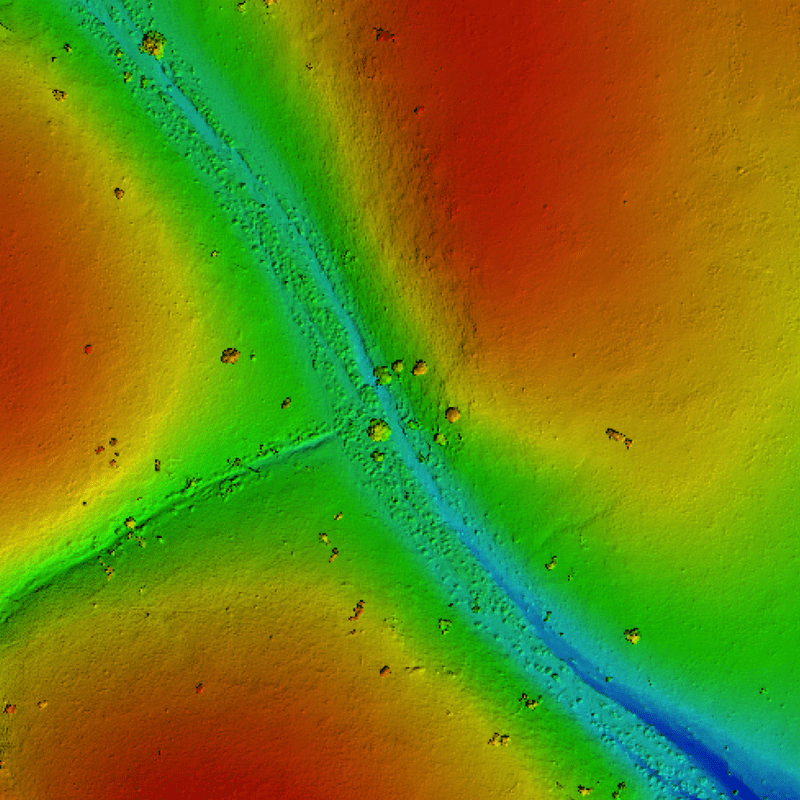
| Linking ground, air and satellite data leads to a much better understanding of how remotely sensed observations relate to ecologically meaningful properties of our ecosystems (images courtesy of Kasper Johanson (UQ) and Paul Hesse (MQ). | |
UAVs address major research and land management challenges
Yincai Zhou (UNSW) was instrumental in facilitating UAV operations, stating that the pilots did “remarkably well to collect data that addressed challenges ranging from quantification of vegetation structure and species composition, and change, identification and counting of large native mammals and stock, mapping of bird species distributions and discrimination of geological formations”.
Dedicated teams of scientists conducted relevant, scientifically robust and concurrent ground data collection (including TERN AusCover SLATS star transects for vegetation cover, AusPlots surveys for vegetation cover, height and species composition, and animal surveys) to assess how well the UAV operators were able to address these challenges.
Counting kangaroos and stock
The workshop came up with several exciting applications. Steve McLeod (NSW Department of Primary Industries (DPI)), Rhys Wyber and Xurxo Gago (University of Wollongong) and Matt Allan, Glen Crombie and Max Richardson (NSW National Parks and Wildlife Service (NPWS) sought to investigate how data acquired using optical sensors at different camera angles and flying heights could be used to locate and count kangaroos, emus and stock.
“I was blown away by the potential of the UAV technology,” said Steve. “In our normal line of duty, and with a team of three, we can walk about 200 kilometers a week counting kangaroos, but with the drones, we were able to image a kilometer in about 3 minutes.”
As such, the approach may well be adopted to better undertake surveys of large native mammals, particularly as a permanent visual record is also obtained.
Agriculture Victoria, the NSW DPI and NPWS were also interested in the application of UAVs for more accurate and efficient identification of stock in pastoral areas where knowledge of their density and spatial distribution is essential for determining pasture use and avoiding degradation.
Richard Lucas (UNSW), the event’s principal organiser, says that “Thermal imaging, direct observation, multi-spectral and stereo models were all used to identify large animals and infer distributions within the landscape.”
A multispectral image aquired at Fowler’s Gap Research Site using a Parrot Sequoia sensor that will allow scientists to analyse plants’ vitality by measuring the amount of light they absorb and reflect (image courtesy TerraLuma).
Vegetation and habitat monitoring and carbon accounting
Other participants tested different sensors to show the variety of ecosystem science applications that can be achieved, such as detailed biodiversity assessments and studies of biomass and carbon storage.
“Various acquisitions allowed up to seven separate canopy height models of vegetation to be generated and the comparison of these will inform others of the optimal approaches,” says Richard. “In these and other topic areas, the diversity of approaches and innovation was remarkable and the outcomes were beyond expectations.”
Arko Lucieer and his TerraLuma team were able to test a wide range of sensors that provided high quality data for plant species discrimination and structural attribution. Such information can contribute significantly to ecological research and national datasets (such as the TERN National Biomass Library) and also support applications relating to land clearing, regeneration, fire and carbon budgeting.
Simon Griffith and James Savage (Macquarie University) were part of another group led by the Australian National University that was using UAVs to study birds.
“The workshop showed that UAVs are providing a unique opportunity to capture the characteristics of vegetation which can be used directly to identify ‘favoured’ habitats or as input to species distribution models at fine spatial resolution,” said Simon. “These data can add valuable new perspectives on over a decade of previous intensive ground observations.”
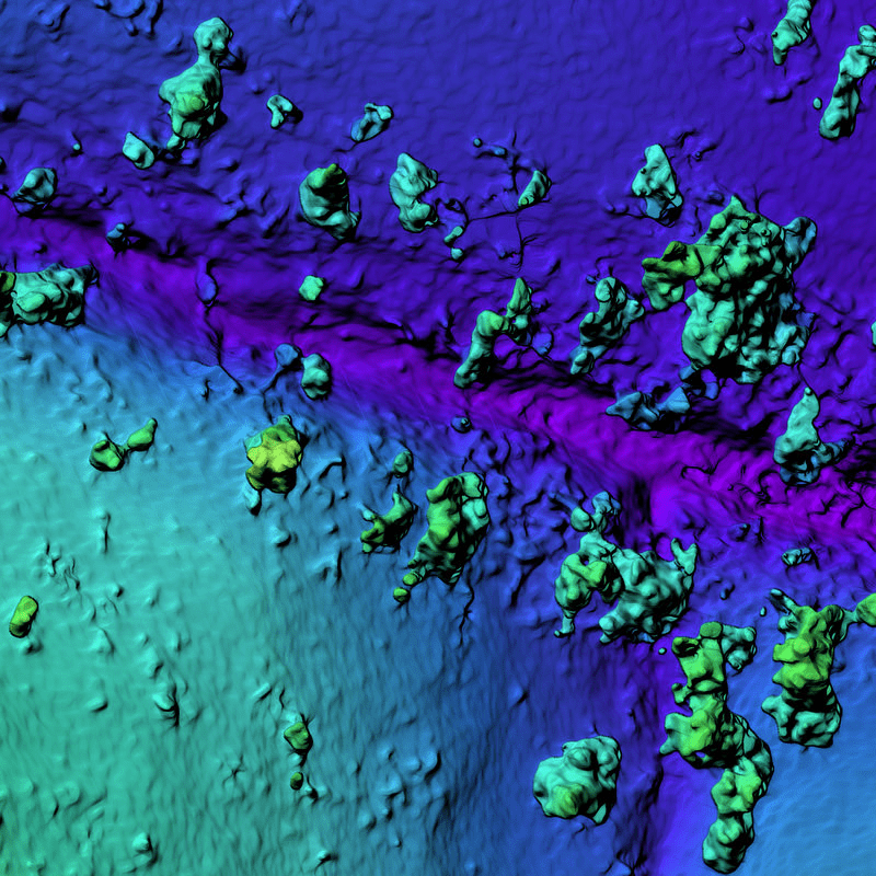 |  | 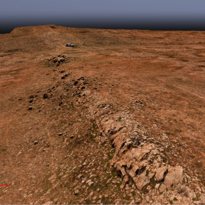 |
| UAV captured imagery can address land management challenges ranging from quantification of vegetation structure and species composition, and change, identification and counting of large native mammals and stock, mapping of bird species distributions and discrimination of geological formations. For example, aerial lidar scans (left) capture the 3D structure of vegetation; and Digital Surface Models (centre) and 3D models produced from overlapping photos indicate elevation and capture the landscape in unprecedeted detail. (Images courtesy of TerraLuma and Kasper Johanson (UQ)). | ||
Open data for continued science
Integrated airborne, UAV and field data acquired at the Fowler’s Gap station, including those from the six TERN AusPlots sites, will be made publicly available for scientific research via TERN’s data infrastructure.
These data—the most comprehensive integrated airborne, UAV, ground dataset in Australia— will also be released as an educational resource and used by the participating institutions.
Adrian Fisher (Joint Remote Sensing Research Program) played a key role in putting together the spatial data layers to support the airborne and field data acquisitions and says that “the new datasets at Fowlers Gap are an invaluable resource that builds on the decades of research conducted previously at the site and will contribute to the development of many remote sensing algorithms for routinely mapping and monitoring Australia’s landscapes.”
In addition to providing the operational support and data infrastructure for this project, TERN is also playing a key role in the development of important protocols for UAV flights and data delivery.
The collaboration of ecologists, land managers and remote sensing scientists using state-of-the-art sensor technology and ground-survey techniques demonstrated how focused effort can significantly advance our studies of complex natural and management systems.
“The level of interest and collaboration between the participating scientists and practitioners was more than we could have hoped for when we developed the concept behind the event,” stated Richard Lucas (UNSW). “A greater understanding of the capability of UAV sensors, the requirements for ground data collection, and the needs of field scientists was obtained as a consequence”.
TERN, through the support it receives from NCRIS, plays a pivotal role in facilitating such collaborations. This project is yet another example of how TERN’s shared ecosystem observatory infrastructure is allowing Australia’s scientists and managers to collaborate and synthesise effectively across regions and disciplines.
- The Fowler’s Gap UAS Field Campaign 2016 was organised by Professor Richard Lucas, (UNSW), Associate Professor Arko Lucieer, (UTAS), Dr Keith Legget, (UNSW), Dr. Yincai Zhou (UNSW) and Dr Adrian Fisher (UNSW/UQ).
- For more information on the Fowlers Gaps UAV Field Campaign, please refer to the website, which will be regularly updated to inform of data access, research outputs and educational resources.
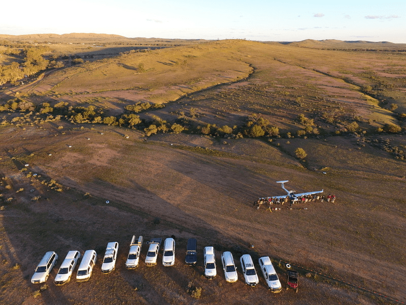
During September 2016, over 30 people from universities and government departments across Australia gathered at the University of New South Wales’s (UNSW) Fowlers Gap Research Station to conduct Australia’s first—and one of few in the World—integrated Unmanned Aerial Vehicles (UAV), aircraft and ground field campaign.
 Detecting landscape change with drones – Fowler’s Gap UAV Campaign 02 from TERN Australia on Vimeo.
Published in TERN newsletter October 2016
