A long-established research site that measures interactions between the atmosphere and production eucalypt forest on the western edge of the Snowy Mountains has been integrated into TERN’s Australian Supersite Network.
The landscape observatory site, at Tumbarumba, in the Bago State Forest, has been part of the OzFlux network since March 2000, and is one of the few southern hemisphere sites that has provided records for longer than a decade of the weather, climate, net uptake of CO2 and loss of water via evapotranspiration. Bago is a managed, open wet sclerophyll eucalyptus forest, and the partnership between OzFlux and the Australian Supersite Network is expected to improve understanding of how logging practices affect the amount of carbon and water entering, stored in and leaving the forest, and how these factors in turn influence the ecosystem as a whole.
Apart from continuously measuring the exchanges of carbon dioxide and water vapour between the forest and the atmosphere, Tumbarumba has been the site of various intensive measurement campaigns to improve our understanding on how airflow, terrain and forest structure affect the way the ecosystem takes up and releases carbon and uses water. As part of this effort CSIRO has carried out independent measurements of carbon pools, stocks and turnover rates. These measurements, along with atmospheric fluxes, have been used to improve the surface–vegetation–atmospheric–transfer (SVAT) models. SVAT models describe how energy, carbon and water are exchanged between land and atmosphere, and Tumbarumba has played a major role in improving SVAT modelling in Australia over the last decade.
Tumbarumba has also been a key site for measuring the important effects that vegetation has on the lower atmosphere, including the exchange of heat, and the production of particles and chemical species that are highly reactive and contribute to the formation of aerosols. A large international campaign provided measurements of the characteristics and dynamics of atmospheric ions, aerosol particles, and their precursors.
Detailed observations on leaf area index taken from both hemispherical photography and forest structure measurements using Echidna have been used to evaluate plant growth and canopy cover. Echidna is a ground-based laser that scans a full hemisphere from a point on the forest floor and is used for ecological assessment and to estimate wood volume and forest growth. This is complemented by data on above-ground biomass taken through airborne LIDAR surveys carried out by AusCover. The LIDAR data, in combination with hyperspectral data, offer the means to look at forest disturbance after harvest.
The Tumbarumba flux station is supported by TERN, CSIRO and the the Department of Climate Change and Energy Efficiency (DCCEE) through the Australian Climate Change Science Program (ACCSP).
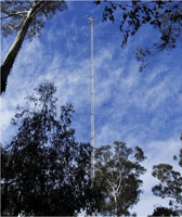 | 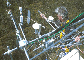 |
The OzFlux tower at the Tumbarumba site (left) and the view from the top (right)
(Photos courtesy of CSIRO)
Published in TERN e-Newsletter August 2012
