TERN’s Australian Centre for Ecological Analyses and Synthesis (ACEAS) facility currently has 26 groups working on challenges in northern Australia. These groups comprise ecosystem studies scientists and natural resource managers from across Australia and overseas, who are working together to integrate, analyse and synthesise ecosystem data to aid in the understanding of the science, and the development of evidence-based environmental management strategies and policy.
One such working group has tackled the difficult problem of reconciling multiple objectives in managing our northern coastal catchments. These objectives typically include biodiversity conservation, maintaining ecosystem services, achieving river-mouth targets for water quality, and promoting development and livelihoods. The group involved experts from James Cook and Charles Darwin Universities, and importantly, two management representatives from four diverse study catchments in northern Australia: the Wet Tropics (north Queensland), Gilbert (Northern Gulf, Queensland), Daly (Northern Territory), and Fitzroy (Western Australia).
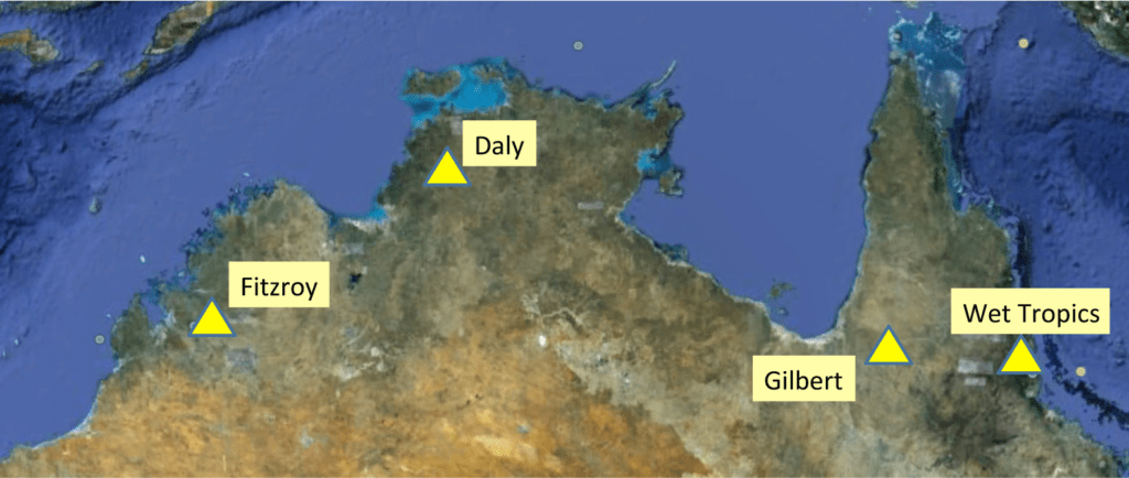
A map showing the location of the four diverse study catchments in northern Australia: the Wet Tropics (north Queensland), Gilbert (Northern Gulf, Queensland), Daly (Northern Territory), and Fitzroy (Western Australia) (Courtesy Bob Pressey and Google Maps).
The group is linked to two research projects funded under the National Environment Research Program (NERP), both directed at integrating data, modeling, governance, and management in the study regions. The ACEAS working group played a major role in shaping the direction of these projects, and ACEAS funding made it possible to link managers and scientists from all four catchments.
The group’s final report outlines a landmark generalised approach to catchment-to-coast planning that can be applied to any catchment to help managers make clear and defensible decisions about how to allocate limited budgets across potentially competing objectives. The framework will result in NRM plans that are more comprehensive in their approach to managing connected realms (terrestrial, freshwater and marine) as well as allowing clear visualisation of trade-offs that must be made when there are limited resources and not all objectives can be achieved.
Other ACEAS groups working on topics relevant to northern Australia include investigating the threats to the survival of the Northern Quolls; using vital long-term data from sites such as Kidman Springs for improved ecosystem health and agricultural productivity; linking remotely sensed ground cover to land management priorities; and working out opportunities and challenges facing Indigenous peoples in the savannah regions of northern Australia and other countries around the Arafura Sea.
Data snapshot:
The ACEAS Data Portal is up and running and is regularly being updated with new datasets. Amongst others, the portal currently contains data on Australia’s fire regime niches.
Recent publications:
Adams, V. M., Álvarez-Romero, J. G., Carwardine, J., Cattarino, L., Hermoso, V., Kennard, M. J., Stoeckl, N. (2013). Planning across freshwater and terrestrial realms: cobenefits and tradeoffs between conservation actions. Conservation Letters n/a-n/a. doi: 10.1111/conl.12080. Available online.
Keith D.A., Mahony M., Hines H., Elith J., Regan T., Baumgartner J.B., Hunter D., Heard G.W., Mitchell N.J., Parriss K.N., Penman T., Scheele B., Simpson C.C., Tingley R., Tracy C.R., West M. and Akçakaya R. (2014) Detecting extinction risk from climate change by IUCN Red List criteria. Conservation Biology DOI: 10.1111/cobi.12234. Available online.
Upcoming events:
ACEAS will be holding its 2014 Grand Workshop in May. Check the ACEAS website soon for more information.
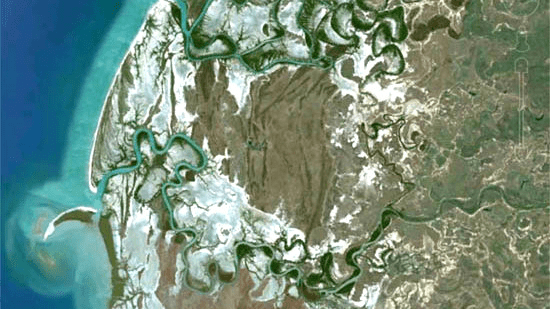
The lower reaches of the Gilbert River, one of the group’s study areas, as it flows into the Gulf of Carpentaria (Courtesy of Google Earth).
Published in TERN newsletter March 2014
