TERN’s fire experts are lighting the way in the geographical study of fire
The pyrogeography synthesis group of TERN’s Australian Centre for Ecological Analysis and Synthesis (ACEAS) facility has successfully mapped Australia’s fire regimes, helping contextualise regional approaches to fire management.
Such is the size and biodiversity of Australia that fire management practices appropriate for one area may be entirely inappropriate for another (e.g. grazing as a fire management tool in central Queensland vs. the Australian Alps). To help unravel this complexity, the ACEAS group splits Australia into ‘fire countries’: broad biogeographic areas with similar patterns of fire regimes and fire management issues.
To create Australia’s fire countries the ACEAS group reclassified continent-scale vegetation maps, defining classes based on typical fuel (e.g. litter, grass, shrubs) and fire types (e.g. surface, crown, and ground). Classes were intersected with a broad climate classification to derive a map of 20 fire regimes.
Using expert elicitation and a literature search, the group validated each fire regime and characterised typical and extreme fire intensities and return intervals. Satellite-derived active-fire detections were used to determine seasonal patterns of fire activity within fire regimes.
With the new map in hand, the group found that Australia’s fire regimes are closely correlated with summer monsoon activity. Frequent, low-intensity fires occur in the monsoonal north, and infrequent, high-intensity fires in the temperate south. Fire is rare in dense-canopied vegetation, such as arid Acacia shrublands, due to sparse fine fuels, and rainforests, due to the combination of sparse fine fuels and infrequent microclimatic conditions suitable for fire.
Information such as this will enable fire managers to tailor their activities on a regional basis according to similar fire countries. For example, managers can now use the map to discern that forest A is in the same fire country as forest B, and that similar fire management strategies may be appropriate. Or discover that forest C is in a different fire country from A and B, and requires a dissimilar fire management approach.
The group’s findings also highlight Australia’s vulnerability to global environmental change. Predicted increases in fuel abundance and the frequency of extreme fire weather conditions, such as strong winds, low humidity and less rainfall, will have profound effects on certain fire countries and subsequently how they are managed.
‘The approach we have developed will allow land managers to better predict the impacts of global environmental change on ecosystems,’ says the group’s principal investigator Brett Murphy of The University of Melbourne.
‘We expect that fire regimes in high rainfall areas, such as southern Australia, will be most strongly affected by changes in the frequency of severe fire weather, while fire regimes in low rainfall areas, such as central Australia, will be most affected by changes in productivity and fuel abundance, possibly as a result of changes in rainfall or atmospheric CO2 concentration.’
Understanding potential climate-driven changes to fire regimes such as these and adapting our fire management to match is vital. Fire has long been a critical process in Australian landscapes, evoking changes in impacting biodiversity and ecosystem function, human health, safety and property, and atmospheric greenhouse gas concentrations, so it is research such as this that is integral to our continued way of life in the land of bushfires.
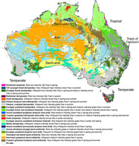
The distribution of major fire regimes or fire countries throughout Australia
Published in TERN newsletter January 2014
