
Professor Stuart Phinn, TERN Associate Science Director, in the Robson Creek
site on the front page of The Cairns Post on 13 September 2012
Over two weeks in mid-September, a diverse group of scientists and volunteers participated in a groundbreaking multidisciplinary effort at Far North Queensland’s latest research asset – a 25 ha (500 m x 500 m) plot of rainforest at Robson Creek on the Atherton Tableland.
The FNQ Rainforest Supersite, which is run out of James Cook University (JCU), is a member of the Australian Supersite Network (ASN), a group of 10 supersites across the country selected for their ability to improve our understanding of how Australia’s ecosystems respond to environmental change. This national effort is supported by TERN, and, in the case of the FNQ Rainforest Supersite, also by Queensland Government funding. Associate Professor Mike Liddell leads the ASN from JCU in Cairns.
‘The upland rainforests of the Wet Tropics are some of the most biodiverse terrestrial ecosystems in Australia,’ says Mike. ‘These forests also have amongst the highest biomass per hectare found on the planet. That’s why there’s so much interest in the role of the FNQ Rainforest Supersite as a nationally important baseline for remote-sensing methods.’
And the interest is not just scientific – the Cairns Post ran a front-page article on TERN’s field campaign.
Activities commenced in 2009 at the supersite’s Robson Creek node, which is managed by CSIRO, and teams have essentially completed measurements of every tree in the 25 ha plot. They’re now moving into the next stage, which will link on-the-ground measurements to plane- and satellite-based methods of remote sensing.
Specialist teams from TERN’s AusCover facility, including groups from universities such as UQ, JCU, RMIT, Flinders and UTS, representatives from agencies such as CSIRO and the Queensland Government, plus some international visitors and local volunteers worked together and achieved considerable progress despite leeches and sometimes adverse weather conditions.
Ground-based teams used a wide range of instruments and methods to derive as many quantitative measures of forest structure and composition as possible, to define the ecosystem characteristics of the rainforest at Robson Creek. Among other activities, they sampled canopy leaves for laboratory analysis, used spectrometers to measure how the trees absorb and scatter light, and used a terrestrial laser scanner to map the three-dimensional forest structure. Airborne Research Australia, a wing of Flinders University, conducted a number of flights over the site in conjunction with AusCover, using advanced radar (LIDAR) and hyperspectral scanning to measure the structure of the research site and the surrounding forest in detail over a 5 km x 5 km area.
‘Many of Australia’s important ecosystem science questions are too big for any of us, or even any one agency, to handle alone,’ notes Mike. ‘The cooperative and collaborative approach being championed by ASN and TERN is essential if we’re to find answers to complex environmental problems.’
‘The sharing of effort and results we’ve seen here this month, and over future years, will not only equip everyone to better understand and manage north Queensland’s tropical rainforests, it will contribute to a better understanding and capacity to monitor and manage ecosystems across Australia.’
Published in TERN e-Newsletter September 2012
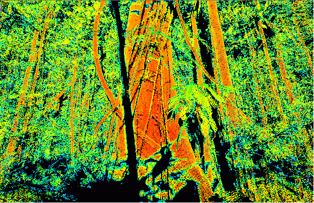
One of the scans produced by the terrestrial laser scanner at Robson Creek, showing the three dimensional forest structure (Image courtesy of P. Scarth)
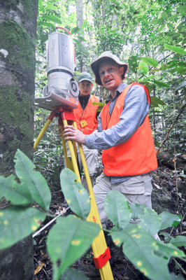
Dr Kasper Johansen (front), AusCover Science Coordinator at the University of Queensland, prepares the terrestrial laser scanner for use at Robson Creek. With Kaspar is David Frantz, a student from the University of Trier, Germany,
who is visiting the Queensland Department of Science, Information, Technology, Innovation and the Arts. (Photo courtesy of S. Long)
