A new web-based tool is making it easier for natural resource management groups, scientists and policymakers to download complex environmental, social and economic data then combine and analyse it on their own PCs using the multi-criteria analysis software called MCAS-S.
The new TERN AusCover developed Data Download Tool works hand-in-hand with the Multi-Criteria Analysis Shell for Spatial Decision Support (MCAS-S), which has been developed by the Australian Bureau of Agricultural and Resource Economics and Sciences (ABARES) and is freely downloadable software that allows users to view and classify map layers; adapt and combine map layers in ways that provide insight into key relationships; and produce statistical reports for regions simply and quickly.
The MCAS-S Data Download Tool allows users of ABARES’s MCAS-S software to quickly and easily preview and download data suitable for Natural Resource Management (NRM) stored by the National Computational Infrastructure, called the MCAS-S Datapack, and load it into MCAS-S for analyses. Using the MCAS-S Data Download Tool, users can also view important information about the data, called metadata, such as its source, references, contacts and dates.
Lucy Randall of ABARES has been working with TERN’s development team from AusCover and says that the addition of the data download tool to MCAS-S will facilitate easy open-access to a wealth of useful data for NRM decision support.
‘The MCAS-S Datapack has a large amount of environmental, social and economic data, collected by state and national agencies, that are of great value to people wanting to carry out agricultural or environmental multi-criteria analyses using MCAS-S,’ says Lucy.
‘The recent addition of the data download component to MCAS-S will mean that these stakeholders are now able to browse the datapack, preview data layers, and download them straight into an MCAS-S-ready format on their PCs. It’s a great addition to the tool and one we’re very excited about.’
The tool’s lead developer, Matt Nethery of AusCover and the CSIRO, explains just how this is achieved with an ‘under the hood’ look at the tool. ‘The download tool consists of public facing HTML (plus JavaScript) pages providing an interface to backend web services and the datastore all hosted by the NCI,’ says Matt.
‘All the data layers are also available via the Open Geospatial Consortium (OGC) Web Mapping Services (WMS) standards, provided by the open-source GeoServer web application, allowing layers to be downloaded into various WMS capable GIS applications, including the popular GoogleEarth, in addition to MCAS-S.’
The MCAS-S Data Download Tool is currently in its trial phase and is undergoing improvements following feedback from MCAS-S partners and test users. Despite this, users can access the current ‘beta’ version of the download tool and download zipped files containing their selected layers. Over the coming months developers plan on adding a function that allows users to download the entire 30 gigabyte MCAS-S datapack containing every available data layer.
MCAS-S has already been applied to several types of issues including forestry and reef management, wildfire assessment, wild dog control, and risk management of animal disease. It’s exciting to think of the possibilities as MCAS-S and its new Data Download tool combine to allow complex data to be more readily accessed and applied by researchers and decision makers all around Australia.
TERN is part of the collaborative MCAS-S development team that includes ABARES, NSW Office of Environment and Heritage, Australian Collaborative Land Use and Management Program, NERP Landscapes and Policy Hub, Barry Consulting and fellow NCRIS funded facility the National Computational Infrastructure (NCI).
- For more information on MCAS-S please contact Lucy Randall.
- For more information on the MCAS-S Data Download Tool please contact Matt Nethery.
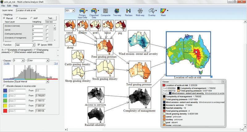
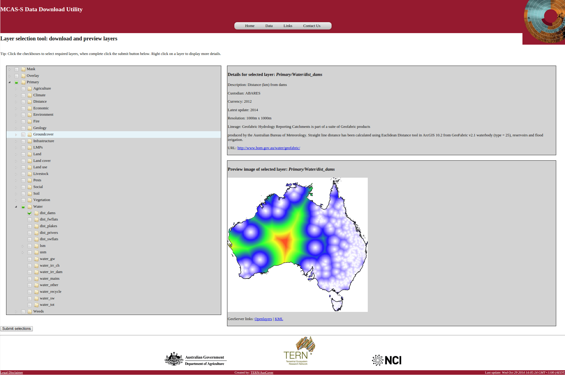
MCAS-S is a multiple-criteria decision analysis tool that allows users to adapt and combine map layers in ways that provide insight into key relationships and produce analyses that can be used to support land-use decision making processes. The screenshot above illustrates the combination of a number of input criteria and primary data layers shown on the left to create a ‘location of soils at risk’ layer shown on the right (screenshot from the MCAS-S user guide). The screenshot below is of the TERN AusCover developed MCAS-S Data Download Tool that links with MCAS-S to allow users to easily download large amounts of data for input into MCAS-S.
Published in TERN’s Ecosystem Data Newsletter March 2015
