Quick and efficient measurement to assess vegetation in natural ecosystems around Australia is being made possible by an innovative research project combining computer vision and environmental science.
University of Adelaide and TERN researchers are developing a method to automatically determine the biomass (total amount of plant material) by analysis of a set of panoramic photographs taken at wooded sites.
These images have been taken at 300 sites around the country in a variety of ecosystems to establish a baseline measure of the condition of Australia’s natural vegetation.
Research Associate Dr Ben Ward, from University of Adelaide’s Australian Centre for Visual Technologies in the School of Computer Science, is using computer vision and machine learning techniques to estimate the cross-section of each tree photographed at a standard height of 1.3 metres (known as the basal area measurement). Machine learning is a type of artificial intelligence involving pattern recognition of data.
“Our system analyses a set of three 360 degree panoramas from the centre of a site and then processes the images to produce a 3D reconstruction,” Dr Ward says.
“From that, the system automatically detects individual trees, estimates the diameter at 1.3 metre up the tree trunk and puts them all together for an overall estimate of the biomass of the site.
“This is a much more efficient method of biomass estimation than the standard method of direct measurement, which is very labour intensive, using laser readings which is very accurate but expensive, or other rapid measures which only provide crude estimates. The field method is quick and simple, and requires minimal training.”
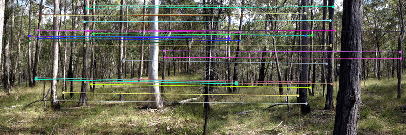
Software compares similar photos from the different exposure points and identifies matching points in each image. The camera positions are reconstructed and the location of each point in 3D space is calculated.
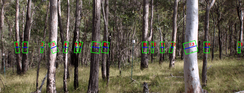
Tree trunks are then identified using an automated process. Best fit cylinders are fitted to each tree trunk and their diameters are measured at 1.3m above the ground (DBH).
Dr Ward is working with TERN’s AusPlots team, led by ecologist and AusPlots Director Ben Sparrow.
“We need to be able to establish a baseline of the current state of ecosystems to be able to measure environmental change,” says Ben.
“This system is allowing us to take a snapshot of Australia’s natural vegetation in an efficient manner that can be reproduced easily to see how quickly things are moving.
“By bringing together a computer scientist and an ecologist to work collaboratively, we’ve been able to produce an automated process for environmental measurement to help us manage and protect our natural environment.”
The new method of measuring biomass is quick, easy, cheap, versatile, and above all, accurate. To try out the new method for yourself contact the TERN AusPlots team via their webpage.
AusPlots Director Ben Sparrow discussing the photopoints method with Leah Wasser from the USA based National Ecological Observatory Network (NEON) at the 2013 American Geophysical Union (AGU) Conference in San Fransisco (photo courtesy of Bek Christensen)
Published in TERN’s Environmental Monitoring Newsletter – October 2014