
Research using TERN-delivered remote sensing data and digital soil maps has assessed the state and trends of hillslope erosion across New South Wales. The new approach for monitoring and predicting hillslope erosion is significantly improving land management practices and bushfire recovery activities nation-wide.
Hillslope erosion is a widespread natural hazard which often causes land and water quality degradation, says Dr Xihua Yang of New South Wales Department of Planning, Industry and Environment (DPIE) and the University of Technology Sydney.
“Consistent and continuous erosion monitoring will help identify the impact of land management practices and improve soil condition.
Using data made openly available by TERN and other organisations, I’ve been able to develop an improved modeling approach for estimating hillslope erosion across large areas and understand how it’s changing over time.”
Dr Xihua Yang, NSW Department of Planning, Industry and Environment
Dr Yang used the digital soil samples provided by the TERN Soil and Landscape Grid of Australia together with climate projections and NCRIS-enabled MODIS Satellite data on vegetation cover to develop his spatial and temporal analysis.
Erosion risk areas identified
Dr Yang’s just published paper uses the new approach to identify high erosion risk areas for the whole of New South Wales (NSW).
“The areas with highest erosion risk were the North Coast, Hunter and Greater Sydney regions. The Western region had the lowest hillslope erosion risk due to its flat terrain.
Hillslope erosion in NSW has generally been decreasing over the past 18 years, with a reduction of 16% between 2015 and 2017 compared to the previous 15-year period. However, the future hillslope erosion is predicted to increase by about 7–21% in the next 60 years due to the likely increase in extreme rainfall events and decrease in groundcover.”
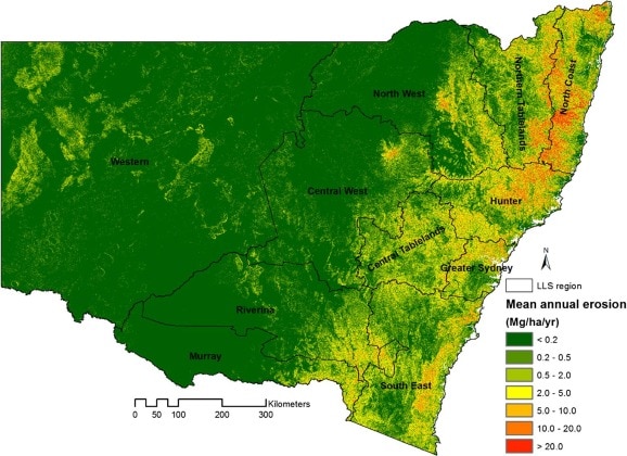
The modelled mean annual hillslope erosion rates (Mg ha−1 yr−1) across New South Wales Local Land Service (LLS) regions, Australia.
Land management support and
scaling-up
Whilst Dr Yang’s study has focused on NSW, due to the availability of open datasets (including TERN’s), his methodology can potentially be applied elsewhere in Australia.
The modelled products produced in the study for NSW, at monthly and annual intervals, are available online via the SEED (Sharing and Enabling Environmental Data) data portal and are already being used by government agencies and research institutions in a variety of applications.
“For example, NSW Rural Fire Services [RFS] is using the erosion risk maps to streamline their Bush Fire Environmental Assessment Code; the NSW DPIE is using the time-series hillslope erosion estimates in soil condition and water quality monitoring and bushfire recovery assessment; NSW EPA is using hillslope erosion and the changes in the State of Environment report; WaterNSW is using the time series erosion data to assess the impacts of fire on sediment sources and water quality across drinking water catchments; and the NSW Local Land Services [LLS] is using them to assess land capabilities or constraints under various land use scenarios and develop best management practices.
The model outputs, at higher temporal and spatial resolutions, will provide more detailed and useful information for soil and land management and climate impacts assessment at regional and local scales across NSW such as the Local Land Service regions.”
Dr Yang says that future studies are in the pipeline and will be focused on improving the model’s capability and consistency for larger areas or the entire Australian continent. In fact, some of his methods have already been recommended by the CSIRO and Australian Government to be applied across Australia.
And, with a consistent and automated methodology and the global rise of open and FAIR data policies, it is easy to see this Australian research breakthrough being adopted overseas.
TERN looks forward to following the development of this exciting research using TERN’s NCRIS-enabled research infrastructure and sharing its good news stories as they come to hand.
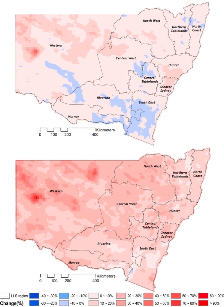
Predicted mean percent change of hillslope erosion risk in the near future (2020–2039, above) and far future (2060–2079, bottom) compared to the baseline period (1990–2019) over New South Wales, Australia.