
Movement restrictions have forged stronger connections between TERN and university educators. Teaching academics no longer able to take their students on field excursions because of COVID-19 are finding value in using TERN’s data and data tools as a way to bring the Australian environment into their online teaching.
Whilst not collected and developed primarily as educational resources, TERN’s data and description of the methods and equipment used are naturally suited to being applied in teaching concepts and skills related to the Australian environment.
These resources are useful in the delivery of high-quality education in both online and regular teaching environments. They are particularly useful as an alternative to field-based data collection.
Staycation field trip
With university field trips canceled and backyard soil sampling not an option for some, Director of First Year Studies at Monash University’s School of Earth, Atmosphere and Environment, Marion Anderson, turned to TERN’s digital soil mapping for alternatives.
“With Victoria’s COVID lockdown extended until the end of semester, we had to cancel our normal field trip for the Earth Atmosphere Environment unit.
It’s one thing to read about the importance of soil in a textbook. It’s another to see it revealed by real-world data so a ‘staycation field trip’ using TERN was the next best thing.”
Marion Anderson, Monash University
The assignment set by Prof. Anderson requires the course’s 460 students to download an easy-to-use KMZ data file on the soil in their local area via TERN’s Soil and Landscape Grid of Australia (SLGA)—which provides detailed digital maps of the country’s soil and landscape attributes at a finer resolution than ever before.
Students are then asked to compare their local soil properties (e.g., soil depth, organic carbon, pH, available water capacity, nitrogen, phosphorus – all available via the TERN SLGA) with weather data, local plant species and historical satellite images to understand environmental change in their region.
“They will write reports on how these factors are connected, what their area’s vegetation and environment may have been like before European settlement, and how it may change in the future, given the information in the IPCC WG6 report.
We have students locked down throughout Melbourne and regional Victoria, and many stuck in other locations around Australia, so TERN’s Soil and Landscape Grid of Australia is perfect for this task.”
Marion Anderson, Monash University

New directions for TERN data use
TERN’s Director, Dr Beryl Morris, says that the emerging interest during the past two years from educators and students at secondary and tertiary levels, in addition to the usual researcher, government and industry users, is causing TERN to look at revising and extending its data training materials.
In 2020, TERN assembled data into an easily downloadable spreadsheet to provide secondary teachers and students with access to large, authentic, environmentally-related datasets—including data from more than 700 of TERN’s continental network of plot survey sites. An accompanying summary document provided information and explanation to help users get started using the TERN datasets.
“Market research in 2021 indicates that the classroom interest in TERN’s ecosystem data continues to grow and the need for training and educational material on TERN data is high. Resources permitting, we plan to produce a range of educational resources, such as tutorials, tailored datasets and training videos, in late 2021 and throughout 2022.
TERN also hopes that the surge of interest currently being exhibited in studying backyard soil and garden biodiversity continues after classroom and office access restrictions are lifted!”
Dr Beryl Morris, TERN Director
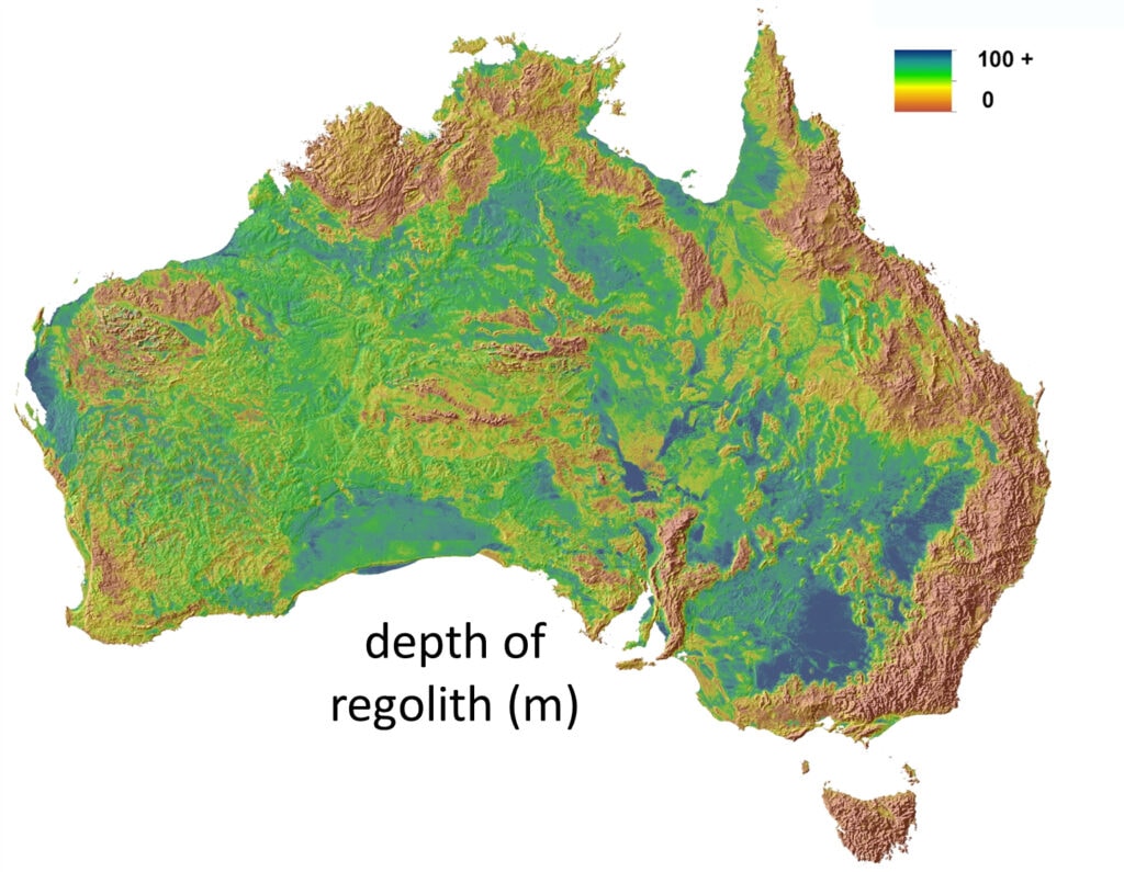
Depth of regolith data from TERN’s Soil and Landscape Grid of Australia
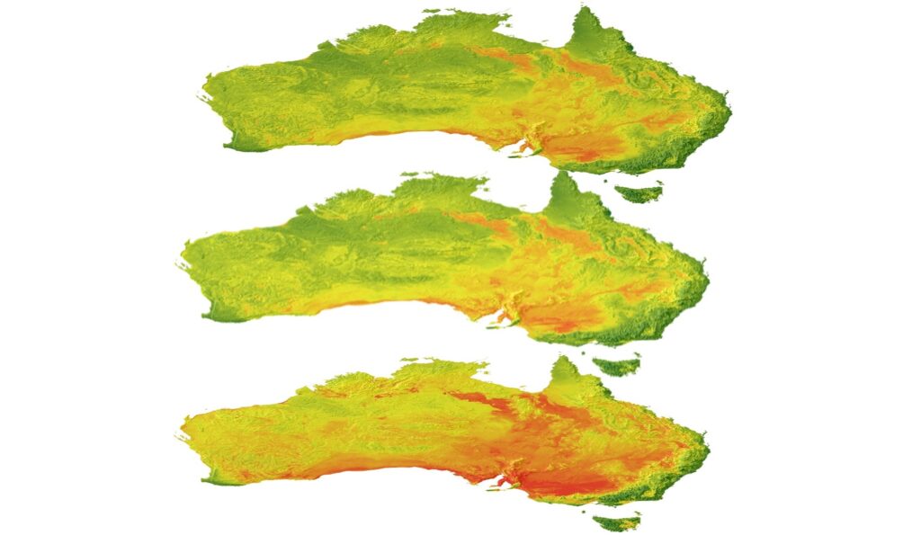
Soil pH data at multiple depths (5cm, 100cm, 200cm) are available via the TERN Soil and Landscape Grid of Australiac