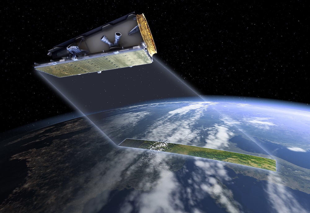
Australian researchers and industry now have access to more than 1,000 high-resolution satellite-collected radar images covering the Australian continent, with more data added every day.
The data are collected by a new observation satellite called NovaSAR-1. CSIRO operates a 10% capacity share in this satellite on behalf of Australia. The data collected so far include images of several TERN SuperSites equipped with flux monitoring and other instrumentation and hundreds of smaller soil and vegetation survey monitoring plots.
Using S-Band Synthetic Aperture Radar (SAR), the satellite provides high-quality images in all weather conditions, both day and night, at spatial resolutions between 6 and 30 metres.
Data collected by the NovaSAR-1 satellite are to be downloaded to a receiving station near Alice Springs owned by the Centre for Appropriate Technologies (CfAT), Australia’s first and only Aboriginal-owned-and-operated ground segment service provider.
Below-ground to sky-high, NovaSAR data adds yet another data layer to TERN’s data-rich monitoring sites
CSIRO’s Dr Glenn Newnham, the co-lead of TERN’s Landscapes platform, says that it is essential we develop a more complete understanding of ecosystem change by integrating data recorded across multiple monitoring scales and sensing technologies. This is best achieved through close collaboration between relevant scientific disciplines and across organisations.
“Ecosystem monitoring using complementary sensing technologies is fundamental to building a more complete understanding of ecosystem change. This understanding is vital for developing more effective evidence-based policy and management.
At the broadest scale, satellites like NovaSAR-1 provide routinely acquired spatial data that can be used to increase our understanding of the natural dynamics of our ecosystems and distinguish these from a deterioration of ecosystem condition, which may require investment in recovery or changes in management practice.
When combined with data collected at TERN SuperSites, across the TERN field plot network and during ecological field surveys, the CSIRO and the broader ecological research community are able to more accurately map, monitor and predict ecosystem change, allowing us to provide the best possible advice about how to conserve and improve this valuable natural resource.”
Dr Glenn Newnham, Principal Research Scientist, CSIRO and co-lead of the TERN Landscapes platform
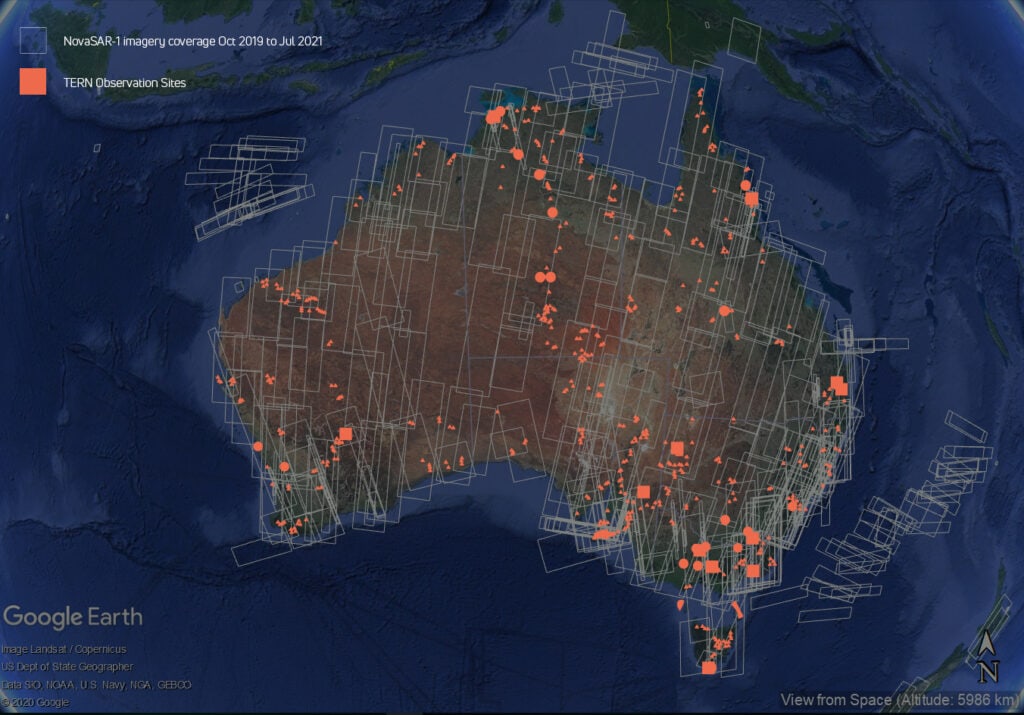
Coverage of NovaSAR-1 imagery tasked and acquired by CSIRO between October 2019 and July 2021 and the locations of TERN ecosystem monitoring sites that provide complementary ground-based datasets (credits: CSIRO, Google Earth, TERN)
NRM, agriculture, mining, construction, and severe weather management to benefit
CSIRO Centre for Earth Observation Director and TERN Honorary Fellow, Dr Alex Held, says that because NovaSAR-1 is not limited by smoke haze or cloud cover, it offers a significant advantage, one recognised in the Bushfire Earth Observation Taskforce report published in December 2020.
“Earth observation data are no longer just a research output. They inform policy, help in management of natural environments, assist recovery from major catastrophes and generate agricultural and industrial development opportunities.”
Dr Alex Held, CSIRO Centre for Earth Observation Director and TERN Honorary Fellow.
A recent economic report by Deloitte Access Economics estimated the economic benefits of the Australian Earth observation sector to be more than $2.5 billion in 2020. The largest beneficiaries were the agriculture, mining, construction, and severe weather management sectors.
CSIRO Satellite Operations and Data Manager, Dr Amy Parker, explained how directing the NovaSAR-1 satellite’s activity provides significant opportunities to support a wide range of existing research and further develop Australia’s Earth observation data analytics expertise.
“We have been using the initial operations phase to learn how best to operate the satellite and we have managed to collect data across the entire Australian continent, which is now available via the NovaSAR Data Hub.”
“We expect applications from projects analysing changes in our land and agricultural practices, waterways and coastal habitats, deforestation and even the recovery from bushfires.”
Dr Amy Parker, CSIRO Satellite Operations and Data Manager
The use of data from the CSIRO-managed NovaSAR-1 satellite, combined with on-ground TERN field data describing key ecosystem variables, by managers and government programs will support better land-use decisions that protect the environment and demonstrate what is possible when a coordinated national approach is adopted.
- Registered users can access the NovaSAR-1 Data Hub which houses more than 1,000 images, covering the Australian continent, with more data added every day.
- TERN is working to make NovaSAR-1 data for TERN sites accessible via the TERN Data Discovery Portal in the near future.
- TERN is also working with CSIRO to help validate methods and derived analysis products from the NovaSAR-1 satellite that relate to key ecosystem variables, such as biomass, fuel load, and vegetation types.
- To find out more about the latest addition to Australia’s suite of Earth observation resources go to CSIRO’s NovaSAR-1 national facility.
- In addition to access to already collected data via the Data Hub, Australian researchers and industry can now apply to access Australia’s share NovaSAR-1. Applications for new acquisitions are open from 8 July 2021, closing 8 September 2021.
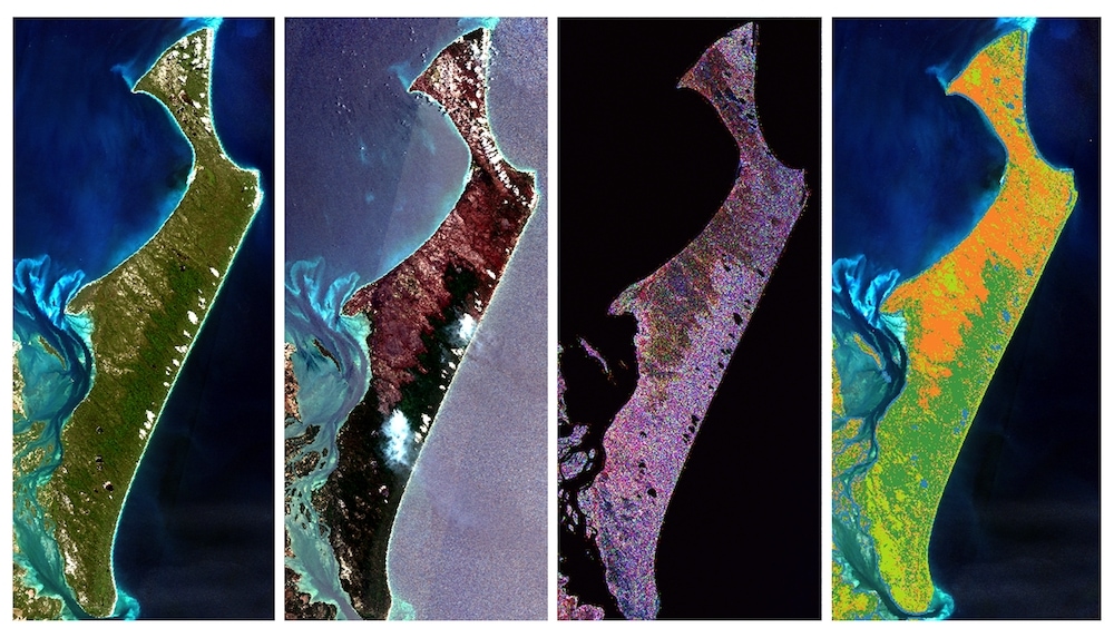
NovaSAR-1 data has helped identify the extent of fire scarring on Fraser Island. From L-R: optical satellite image before fire (Sentinel-2), optical satellite image post fire (Sentinel-2); combined NovaSAR-1 and Sentinel-1 SAR image; classification using SAR data – orange indicates burnt areas. (Credit: C.Ticehurst CSIRO)
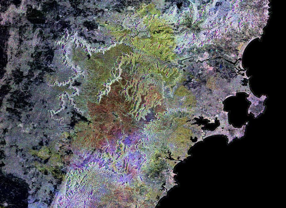
The CSIRO team used NovaSAR-1 images to help identify fire-scar extent along the south coast of NSW. The yellow, red and purple tones show areas where fire damaged the forest near Jervis Bay. (Credit: C Ticehurst, CSIRO)

Centre for Appropriate Technology technicians put the finishing touches on the build of the satellite dish for the earth ground station in Alice Springs. (Credit: Ekistica Ltd.)