
Since 2011, TERN’s research infrastructure in southwest Western Australia has been helping us understand how climate, water and vegetation are interacting at the Gnangara groundwater mound. The Gnangara Mound is a crucial water resource for Perth—and its dependent ecosystems.
Rainfall is declining, the banksia woodlands still need water, so what does this mean for the sustainability of Perth’s water supply? TERN’s Research Infrastructure and data are helping to investigate some of these questions and a new interactive website, built by uni students, tells this story, and visualises the data behind it.
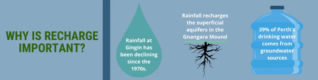
Rainfall has declined in southwest WA since the 1970s, and climate change looks set to exacerbate the trend. Over the same period, groundwater levels around Perth dropped by 20cm each year, partly due to lower rainfall but also because of increased urban demand for aquifer water.
With about half of Perth’s water supply coming from groundwater, accurate long-term data about environmental change has never been so important.
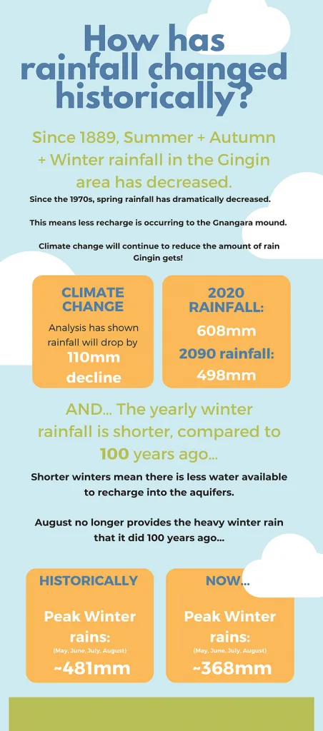
A student-created infographic outlining the changes to climate and rainfall at TERN’s Gingin Banksia Woodland SuperSite north of Perth.
Recharge = rainfall - evapotranspiration
The water that replenishes groundwater is called recharge. Recharge depends on rainfall and how much of it evaporates from soil or is used by plants – the evapotranspiration.
How will water use by native vegetation change with less rainfall and higher temperatures? And, how will this impact groundwater levels and the sustainability of Perth’s water supply? The answers to these questions lie in the detailed data collected by TERN at its Gingin Banksia Woodland SuperSite.
TERN’s Gingin SuperSite is located about 80 km north of Perth. It has specialised equipment that measures the movement of carbon dioxide, water and energy between the atmosphere and the area’s native Banksia Woodland ecosystem. Beneath this woodland lies Perth’s most important groundwater resource, the Gnangara Mound aquifer.
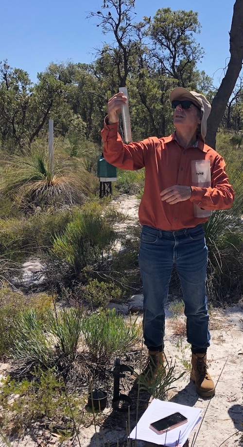
Prof. Richard Silberstein of ECU at one of the Gingin SuperSite’s groundwater monitoring bores
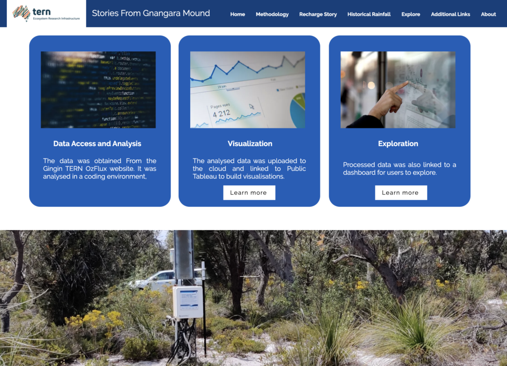
Student-built interactive data visualisation website
Since 2011, data collected at the Gingin SuperSite have been freely available for download via TERN’s data portals. However, they are detailed, complex and vast in quantity, and present challenges for non-expert analysis and understanding.
To address this and create a new interactive data visualisation website, TERN and its Gingin operating partner Edith Cowan University (ECU), worked with Professor Sally Thompson of the University of Western Australia (UWA) and students of the Environmental Engineering Design Master’s course she coordinates.
“The students were inspired by the idea of transforming complex data into easily-accessible knowledge and understanding. As environmental engineers, they were passionate about the sustainability of water supplies, ecosystems and the city. They understand that community education is essential for achieving sustainability – especially in the face of climate change.
Producing the website developed students’ technical understanding of cutting-edge environmental monitoring methods, the science underlying TERN’s approach and the fundamentals of data visualisation. They also improved their “soft” skills ranging from stakeholder engagement to teamwork, communication and project management. Seeing the students’ work publicised and supported by TERN is a tremendously exciting validation of all their hard work.”
Prof. Sally Thompson, University of Western Australia
Visitors to the new Gnangara website can use the interactive dashboard to explore how rainfall, evaporation and recharge change over years, months and days. A visually compelling storyboard explains what controls recharge and what might happen to it in the future.
A new interactive website, built by uni students, tells this story of the Gnangara aquifer, and visualises the data collected by TERN and its partners at the TERN Gingin Banksia Woodland SuperSite
Important pilot project for future TERN data visualisations
The student-developed Gnangara website is also an important pilot project for TERN and its site partners to explore new ways of sharing and communicating TERN data with a broader cross-section of the community.
For example, TERN is currently working on implementing data visualisations as standard across most datasets in the TERN Data Discovery Portal—to complement applications of the TERN ANU Landscape Data Visualiser. TERN is also working with its OzFlux researcher network to roll-out live data widgets that show live raw data streams coming from flux monitoring instruments at TERN sites – these are the data prior to application of TERN’s rigorous quality control and assurance (QA QC) processes and final publication via the TERN Data Portal.
“The new website for the Gingin SuperSite is a fantastic example of the type of storytelling and visualisations that are possible using the data collected at the research site. We continue to work with the UWA students to explore future possibilities including, using the website at the Gravity Discovery Centre near Gingin and other live data widgets for the TERN website. It’s a fantastic student achievement that will not just provide a useful educational outlet, but lead to exciting ‘real-world’ applications and outcomes.”
Prof. Richard Silberstein, Edith Cowan University
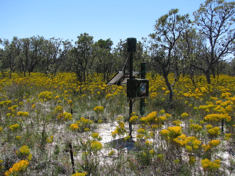
A COSMOS Soil Moisture Sensor provides continuous soil-moisture measurements averaged across a 30 square-hectare radius. Data are available here.
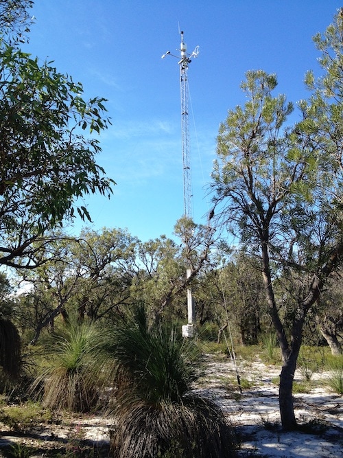
The Gingin SuperSite’s eddy-covariance flux monitoring tower set within a banksia heath woodland (credit: Richard Silberstein)