A natural resource management, research and industry consortium have used TERN environment monitoring infrastructure to deliver an innovative service that equips landholders to make better decisions for improved productivity and sustainability.
The NRM Spatial Hub is a web tool that utilises a combination of commercial cloud computing and TERN data and infrastructure to give farm managers the ability to map their properties, analyse land resources and monitor land condition.
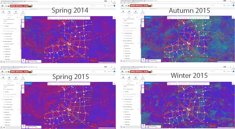
In just a few minutes they can access and analyse the latest time-series ground cover data at paddock scales and also compare their property with the neighbours over the last 30 years.
Landholders and industry bodies alike are hailing the system for its potential to improve on-farm investment decisions and long term sustainable production. Users have identified significant labour savings of up to a month a year; better utilisation of pastures, and with appropriate infrastructure investment, the potential to increase long-term safe carrying capacity and profitability.
The NRM Spatial Hub (the Hub) brings government data to the land manager alongside 30 years of ground cover data, and enables them to integrate it with their own data. It is this wealth of data, and easy-to-use analyse tools that has the ability to transform land management across Australia.
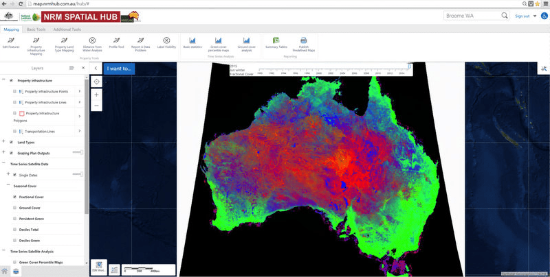
A screenshot from the NRM Spatial Hub showing nation wide ground cover data made available by TERN AusCover
The NRM Spatial Hub has been the result of collaboration of more than 20 organisations led by the Cooperative Research Centre for Spatial Information (CRCSI); the Rangeland NRM Alliance (14 NRM Regional bodies), and the Queensland Remote Sensing Centre.
Recognising the potential of the Hub, Meat and Livestock Australia (MLA) and Australian Wool Innovation (AWI) are providing new support that will allow the Hub to move from a demonstration phase into a sustainable service and business model, with clearly demonstrated value and approval from landholders.
Phil Tickle from CRCSI says that the Hub provides an important step forward in the delivery of valuable government collected spatial data.
“This new mapping and monitoring tool delivers the latest ground cover data to end-users such as graziers and extension staff, which helps them assess changes in production and land condition in relation to management and investment decisions,” says Phil.
“By integrating easy-to-use commercial cloud services with TERN science products, storage and services Hub users can analyse and visualise detailed imagery in their web browser and make critical management decisions based on the latest science.”
“NRM Spatial Hub could not have been developed without TERN AusCover data, infrastructure, expertise and collaboration. The Hub is demonstrating what can be achieved by integrating user-centric applications specifically designed to meet the business needs of rangelands managers with world-leading remote sensing science products and infrastructure provided by TERN AusCover and its collaborators. ”
Regular updates of the ‘fractional cover’ of live and photosynthetically active (green) vegetation, dry or dead vegetation, and bare ground across the Australian continent are produced using Landsat satellite imagery analysed by the Queensland Government’s Department of Science, Information Technology and Innovation (DSITI) and validated with field site information collected by project partners, including TERN AusPlots and TERN’s Australian SuperSite Network.
These imagery products are stored in TERN’s AusCover data infrastructure, where they are linked to the commercial cloud environment of the Hub using AusCover web services and specialised APIs developed by VegCover.
The NRM Spatial Hub enables land manager to report on changes in ground cover for the last ~30 yrs at any spatial unit: property, paddock, land types, or user defined
VegCover co-developed Dr Peter Scarth, of DSITI and The University of Queensland, says that although the behind the scenes workflow of the Hub is very complex, the final user product is not only accurate but also easy to access and use.
“Our APIs connect users’ searches to data on TERN, the Bureau of Meteorology and other open data portals, and return practical statistical summaries, analyses and property comparisons,” says Peter.
“The Hub is pushing the limits of what is possible for data delivery, requiring the retrieval of statistical summaries from large archives of time series imagery in web time”
“And, all this wouldn’t be possible without the landmark public private collaborative ecosystem, of which TERN is a vital part.”
Industry endorsement of the Hub is a clear indication of the value of such a collaborative and open approach to environmental information delivery—and ultimately TERN infrastructure and the data it delivers.
The Hub shows what is possible when there is a coordinated, collaborative and open approach to ecosystem science. TERN is proud to be enabling this exciting new service that is equipping landholders and NRM managers with the information and tools they need to make decisions for more a more productive, profitable and sustainable industry and landscape.
- Farmers interested in using NRM Spatial Hub can join the Hub by completing an application form. Once registered, landholders will be able to attend a Hub Training Workshop, which are currently being held around Australia.
- The nation-wide ground cover data used in the Hub is also openly accessible via the TERN Data Discovery Portal.
Taking research to producers – this is a great collaboration – Thanks to @TERN_Aus @qriscloud @qldscience @NRMHub @FBAupdate … https://t.co/qlnSt5zYH0
— Peter Scarth (@petescarth) September 22, 2016
Terabyte technologies take the beef industry forward. https://t.co/eVuuBXm3Rp #agchatoz #beef #cattle #technology pic.twitter.com/hToupjTrxI
— The Land (@thelandnews) September 22, 2016
Published in TERN newsletter October 2016
