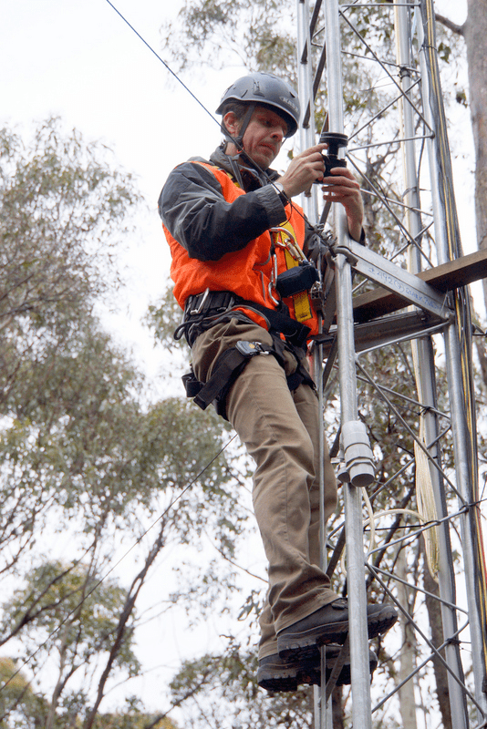
Image: Jan climbs the OzFlux tower at the Wombat node of the Victorian Dry Eucalypt SuperSite to measure the vertical structure of the forest (image courtesy of Zbynek Malenovsky)
A senior researcher from Estonia’s Tartu Observatory recently travelled to Australia to utilise TERN’s landscape research facilities and enable the completion of a global study on the remote sensing of vegetation structure.
TERN’s research facilities are drawing international scientists from all around the world, including from Estonia where Jan Pisek works as a senior research fellow at Tartu Observatory. Jan conducts research on the remote sensing of vegetation and how we can better utilise technology to monitor and measure ecological changes in the landscape.
Specifically, Jan is working to improve the accuracy of remotely sensed measurements of vegetation foliage distribution or ‘clumping’. Vegetation clumping in forest canopies is important as it affects how sunlight is distributed within canopies and influences photosynthesis and other important land-atmosphere interactions such as water and carbon fluxes.
Jan recently travelled to Australia to utilise the research facilities offered by TERN’s OzFlux facility and Australian SuperSite Network and conduct research into vegetation clumping measurements in Australian forests. Alongside local scientists, Jan conducted research using OzFlux’s flux towers at the Victorian Dry Eucalypt SuperSite and the Warra Tall Eucalypt SuperSite as part of a global project to characterise and compare three different products that measure vegetation clumping using remote sensing technology.
‘To study the architecture of your [Australia’s] eucalypt forests I needed access to different heights inside tree canopies so I could collect vertical profiles of foliage clumping,’ says Jan.
‘The flux towers at the TERN sites reach all the way to the top of canopy and were ideal ladders that allowed us to sample the full vertical profile of the surrounding forest stands.
‘We knew that only using measurements collected near the ground surface does not always give an accurate estimate of overall canopy-level clumping, so being able to study the full vertical profile was essential.
‘Having access to the Australian sites was really important as it also meant we were able to test the three remote sensing products over a more representative set of sites from diverse biomes and different canopy structures. The first time such a study has been done,’ adds Jan.
‘We collected data by climbing towers similar to TERN’s all around the world – from Hawai’i, through continental U.S., to different corners of Europe. All the Australian sites we visited had superb equipment and infrastructure and were really professionally run by a great group of researchers.
‘What impressed me the most though was the ease of obtaining the access to the infrastructure and the willingness to help in any way by all my Australian colleagues.
‘Even though I did not know anyone connected with TERN prior to my visit, it was really easy to gain access to the sites via their principal investigators [Stefan Arndt of the University of Melbourne and Tim Wardlaw of Forestry Tasmania].
Jan and his research partners recently published the findings of their research into measurements of vegetation clumping in the ISPRS Journal of Photogrammetry and Remote Sensing.
The team’s key findings published in the paper include:
- Vertical foliage distribution and understory vegetation needs to be taken into account when using field measurements to validate data from remotely sensed foliage clumping products.
- The type of remote sensing technology used will influence the measurement of vegetation clumping with satellite measurements biased by canopies and ground measurements biased by lower vegetation layers.
- Of the three products tested (POLarization and Directionality of the Earth’s Reflectances (POLDER), Moderate Resolution Imaging Spectroradiometer (MODIS) and Multi-angle Imaging SpectroRadiometer (MISR)), the team’s results indicate that two products in particular, MODIS and MISR, can provide good quality clumping index estimates at spatial scales pertinent for modeling local carbon and energy fluxes.
Read more of the project’s key findings here.
Jan would like to thank Stefan Arndt and Julio Najera-Umana of the University of Melbourne, Jason Beringer of the University of Western Australia, Darren Hocking of Monash University, Lola Suarez of RMIT, and Zbynek Malenovsky of the Wollongong University for assistance at the Victorian Dry Eucalypt SuperSite; and Tim Wardlaw of Forestry Tasmania, at the Warra Tall Eucalypt SuperSite.
‘It was just awesome to see how all these researchers from different Australian institutes come together and make sure TERN’s infrastructure is put to the best use’.
To find out more about this project please contact Jan.
If you are interested in using TERN’s infrastructure please contact us.
Published in TERN newsletter January 2015