A scientist with the Australian Bureau of Agricultural and Resource Economics and Sciences (ABARES) working with TERN to improve land management outcomes.
Jasmine Rickards of ABARES is at the forefront of monitoring soil erosion in Australia. For the past 4 years Jasmine has been working with a network of agencies to develop reliable measures of ground cover change. Jasmine’s work is critical for assessing land management practices, such as grazing and broad acre cropping, and for monitoring progress towards environmental targets.
So what exactly does Jasmine do and how does she do it, I hear you ask. Well, it’s probably best if Jasmine explains that herself…
‘I work with a team that provides regular updates of the ‘fractional cover’ of live photosynthetically active (green) vegetation, dry or dead vegetation, and bare ground across the Australian continent through the Ground cover monitoring for Australia project. This is a collaborative project funded by the Department of Agriculture with CSIRO, state and territory agencies, TERN and Geoscience Australia’, she says.
Fractional cover updates are produced using Moderate Resolution Imaging Spectroradiometer (MODIS) satellite imagery accessed via TERN’s AusCover facility, analysed by CSIRO, validated with field site information and made into ground cover maps. The field site information includes field data collected by TERN’s AusPlots facility, which will contribute to the national network of over 1500 observations collected by state and territory agencies. This national network of observations is improving the fractional cover products available from the TERN AusCover facility.
ABARES plays a key role in collating and coordinating land use and management information from across Australia through its partnership network. However, the ABARES systems are not designed to work with the large quantities of ecosystem data that this collation and coordination role sometimes involves. Thanks to TERN’s data management infrastructure, ABARES and its partners are now better able to share data, and ultimately help manage Australia’s agricultural lands more sustainably and productively.
‘It’s great to have access to TERN’s ecosystem data portals to publish ground cover data, and being able to use TERN’s field data for validation will be a bonus. We can work directly with TERN researchers, share lessons from developing ground cover monitoring for Australia, and learn more about the TERN data. By using TERN’s field data, ABARES will be able to provide products that have been tested across a greater proportion of Australia than before’, says Jasmine.
The provision of more consistent and accurate maps of ground cover are a national sustainability indicator, and will mean that environmental researchers and managers can more readily assess soil condition and make progress towards important land management targets.
‘Our work contributes to regional and national reporting of land use and land management practices, status, change and integrated assessments.’
For example, monitoring ground cover improves estimates of the area at risk of wind and water erosion. This in turn enables governments and land managers to better understand the hazards of dust storms by combining information about potential dust sources with weather forecasts through the DustWatch program.
Jasmine’s collaborative work is generating exciting outcomes for land holders too. ABARES produces and distributes summary statistics via its Monitor web tool, allowing the public to view ground cover across Australia and make land management decisions based on that information.
‘It’s very satisfying to know that our work is having positive outcomes for land managers across Australia’, concludes Jasmine.
  |
 |
 |
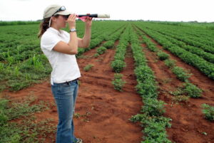
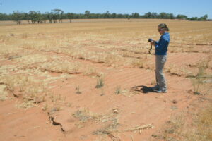
| Jasmine Rickards surveying vegetation cover and soil erosion in a peanut field in the Northern Territory (left) and on agricultural land in New South Wales (right). Jasmine is working with TERN and a network of other agencies to develop reliable measures of ground cover change, critical for assessing land management practices, such as grazing and broad acre cropping, and for monitoring progress towards environmental targets. | ||
Published in TERN newsletter July 2014
