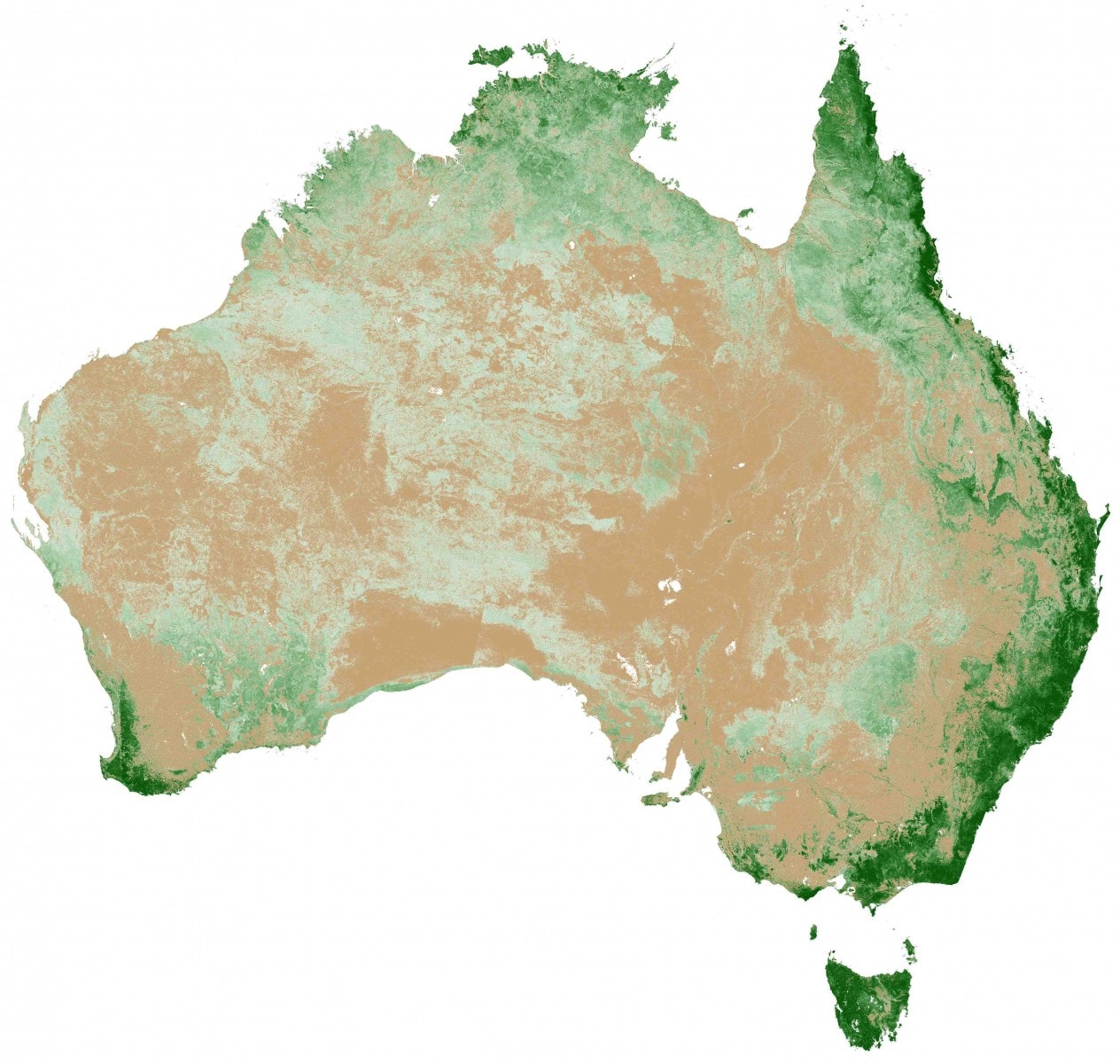
The Persistent Green-Vegetation Fraction 2000–2010 across Australia, which has been developed by AusCover in collaboration with a range of state, territory and Commonwealth agencies. The Persistent Green data and statistics can be accessed through the AusCover data portal.
Here at TERN, we are excited by the new possibilities that are arising for the ecosystem science community through our national ecosystem data infrastructure and the collaborative approach it encourages. TERN’s infrastructure supports novel opportunities for the integration and synthesis of data at broader scales, and helps to foster a networked approach to ecosystem science.
AusCover’s recent production of the Persistent Green-Vegetation Fraction 2000–2010 (‘Persistent Green’) for all of Australia at 25 m resolution, is just one example of what is possible when a coordinated national approach, supported by TERN’s infrastructure, is adopted.
The Persistent Green map provides a robust estimate of areas where green vegetation persists over time, like perennial vegetation, forests and vegetation that has access to fresh groundwater. It also shows areas where green vegetation does not persist over time, which includes bare ground and grasslands that only turn green in response to rainfall.
Separating how trees, shrubs and grasses change over time in Australian environments has been a long-standing challenge.
‘This product can now be used to inform estimates of forest extent and density across Australia,’ says Dr Peter Scarth, one of the AusCover team members who played an integral role in developing Persistent Green. ‘Persistent Green has been validated with a national dataset, and is available through the AusCover portal for anyone to access.’
Persistent Green builds on significant past investments in ecosystem data collection and knowledge development across all states and territories. AusCover relied on data freely contributed by a number of agencies, including the Australian Bureau of Agricultural and Resource Economics and Sciences (Commonwealth), the Australian Collaborative Rangelands Information System (Commonwealth), Bushfires NT, the former Department of Natural Resources, Environment, the Arts and Sport (Northern Territory), the Department of Science, Information Technology, Innovation and the Arts (Queensland), the Office of Environment and Heritage (New South Wales), and the Queensland Herbarium.
The data used to develop and validate Persistent Green spanned a 10-year period and ranged through field observations of vegetation type, vegetation cover measurements and airborne LIDAR scans. These were used to determine fractional cover, which is the proportion of bare ground, green and non-green vegetation. By applying a decision tree to the integrated data sets, the AusCover team were able to identify areas where green vegetation persisted over time, resulting in the Persistent Green product.
‘Persistent Green could not have been developed without AusCover’s infrastructure and expertise to coordinate the project and integrate the data across Australia,’ says Prof Stuart Phinn, TERN Associate Science Director. ‘This product also relied on the collaborative networks that have been fostered across the states and territories, which led to the sharing of data at a national scale. Persistent Green shows what is possible when there is a coordinated and collaborative approach to ecosystem science.’
Persistent Green represents an immense investment of time and effort by the AusCover team, but this is just the beginning.
‘We can now start to refine the product and tailor it for different needs,’ Peter says. ‘For example, it may now be possible to integrate radar and spaceborne LIDAR data to better estimate vegetation density and dynamics of understorey vegetation.’
Published in the TERN e-Newsletter October 2012.
