TERN’s remote sensing data products are enhancing Australia’s contribution to achieving the global Sustainable Development Goals. Learn about the data, the policy and goals they’re informing and the benefits for Australia’s neighbours.
Earth Observation (EO) data open unique windows of opportunity for progress towards the UN Sustainable Development Goals (SDGs), a global plan of action for people, the planet and prosperity.
Big Earth Data is massive, multi-source, heterogeneous, multi-temporal, multi-scale, highly dimensional and complex. It includes EO data from different satellite, airborne and drone platforms, as well as geo-spatial information such as the soil and landscape variables that TERN delivers through its Landscape Research. Big Earth Data, can be used to support project planning and implementation and to monitor change and trends in the wicked problems that the SDGs address, including environmental degradation, climate change, sustainable management of natural resources, fresh water scarcity and loss of biodiversity.
“Big Earth Data can be used by countries for baseline determinations when setting SDG targets, to monitor progress towards agreed targets (which is a responsibility of countries according to their national circumstances), and for national reporting on the SDGs” says Professor Graciela Metternicht of the University of New South Wales Sydney.
“They do not directly deliver the SDG indicators agreed by the UN Inter-Agency and Expert Group, but rather, provide important spatial and temporal information which can then be related to indicators.”
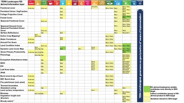
The Big Earth Data delivered by TERN are used to characterise and detect change relating to vegetation structure and composition, land cover, ecosystem disturbance and bushfire dynamics and impacts, and much more.
“The variety of data across both natural and managed landscapes provide a unique quantitative guide in the implementation of target-based SDG strategies across multiple industries,” says Graciela who analysed the potential for each of TERN’s remote sensing datasets as input for SDG targets, building on work of the Committee on Earth Observation Satellites (CEOS).
“TERN’s Big Earth Data contribute strongly to SDGs related to biosphere and society, in particular goal 15, Life on Land, which requires countries to ‘Protect, restore and promote sustainable use of terrestrial ecosystems, sustainably manage forests, combat desertification, and halt and reverse land degradation and halt biodiversity loss’.”
Mangrove data to inform national and global policy
One example of a TERN data product and research infrastructure that’s enhancing Australia’s contribution to achieving the global Sustainable Development Goals is the TERN Mangrove Data Portal.
Launched in 2018, the portal provides open access to decades of historical and newly acquired field and Earth observation data, and delivers on SDG 15, Life on Land.
“Data in the TERN Mangrove Portal provides scientists and managers with information that facilitates monitoring of coastal environmental change, provides new knowledge on the causes and impacts of this change, and supports the sustainable management of our immensely important mangrove ecosystems” says Professor Richard Lucas, of UNSW and Aberystwyth University in Wales.
Openly available via the portal, TERN’s 2017 LiDAR and aerial imagery dataset over the Gulf of Carpentaria represents the largest single dedicated acquisition of such data over a mangrove ecosystem anywhere in the world.
It’s a baseline that is being used by researchers to understand how this dynamic ecosystem is responding to environmental change in Australia. TERN is now collaborating with Vietnam to process satellite imagery of the Mekong River, with the results of this work being used to validate whether the TERN methodology can be applied around the globe.
“Data and systems like this one can inform environmental policy in Australia and will allow the nation to contribute to international environmental conventions, including the SDGs,” says Richard.
“It is hoped that TERN’s efforts in creating this observing system will lead to routine monitoring of mangroves at a national level with input from an expert community in Australia and internationally.”
- TERN’s remote sensing EO platform is a partnership of over 12 government and academic institutions that produces and delivers data about ecosystems using satellites, airborne sensors, and on-ground systems. Click here for more information.
- The TERN Mangrove Data Portal has been listed on Australia’s SGD website as a project that’s specifically contributing towards achieving national SDG targets. You can view the project listing here.
High-resolution airborne imagery collected by TERN in 2017 along the entire coastline of the Gulf of Carpentaria, including this section along the Roper River, documents significant mangrove dieback and is now openly available for download (imagery courtesy of Google Earth and Airborne Research Australia)
