It began as long-term research plot in Tasmania in the 1990s, before the Terrestrial Ecosystem Research Network (TERN) was a twinkle in anyone’s eye. Now it has blossomed into the multi-faceted Australian Supersite Network (ASN).
The network features multiples of all kinds — multiple ecosystems in most states, several stages of establishment and growth, and the involvement of many research institutions. The environment monitoring supersites form the most intensive monitoring sites in the network that makes up TERN’s Multi-Scale Plot Network (MSPN), under the leadership of James Cook University (JCU). Each supersite is an observatory where scientists collect detailed data sets on flora, fauna and biophysical processes. Each contains a main field site that works over at least one gradient (topographical or ecological) transect in a typical and important Australian biome. The focus at a supersite is on developing a thorough ecological and biogeochemical understanding of the ecosystem under consideration. As a network, the major goals are to ascertain if there are general trends in stocks and fluxes (i.e. energy, carbon, water and nutrients) and in the abundance or diversity of flora and fauna across the network in response to climate and disturbance (e.g. changes in land use).
Tall eucalypt forest in a temperate climate
The genesis of the Warra Tall Eucalypt Supersite is an area that was established as a long-term ecological research site in 1997. It now supports six major long-term projects, and several student and post-graduate studies.
Since August 2010, the Warra supersite has been measuring soil fluxes of carbon dioxide (CO2), methane (CH4) and nitrogen dioxide (NO2) using automatic soil chambers. A flux tower being erected nearby will complement this work. These measurements are being augmented by seasonal measurements of CH4 and NO2 fluxes taken using manual chambers installed in the wildfire chronosequence plots. The data collected are being used by Benedikt Fest, a PhD student at the University of Melbourne, to examine the effects of forest disturbance on soil fluxes of greenhouse gases other than CO2. Eddy co-variance instrumentation has been temporarily installed on a 3 metre sub-canopy mast adjacent to the automatic soil chambers. By comparing the difference in night-time CO2 fluxes measured by eddy co-variance and those measured by the soil chambers researchers hope to understand non-soil fluxes, which they expect will be dominated by respiration from the prodigious quantities of coarse woody debris typical of these tall, wet eucalypt forests.
Surveys of birds, ground-active beetles and vascular plants in the Silvicultural Systems Trial (SST) continue. Researchers are surveying treatment plots that were harvested 10 years ago. The data from these will be compared with data from the SST control plots, which have been surveyed annually since 2004 for birds and ground-active beetles. One of the control plots, known as the ‘Bird Track’, lies outside the SST area, but is included because it is only 500 metres upslope of the flux tower and is in comparable forest.
Dr Jennie Whinam and Dr Mike Driessen from the Tasmanian Department of Primary Industries, Parks, Water and Environment will oversee surveys of vascular plants and ground-active beetles in the Mt Weld altitudinal transect this summer. These plots were established and last surveyed in 2000–01. The decadal comparison between the two surveys will help researchers refine gradient monitoring to detect shifts in species distribution that can be attributed to changed climates.
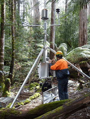
Karl Abetz working on the sub-canopy flux station
Murray River mallee
Currently the major work on the Calperum Mallee Supersite, in the Murray River floodplain of South Australia’s Riverland area, focuses on the existing flux tower, which is supported by OzFlux. The tower site at Calperum Station is typical of sparse mallee woodland ecosystems, one of the three ecosystems covered by the supersite. Closer to the Murray is an area of Callitris woodland that was heavily damaged by grazing and settlement and is now being actively restored. There is also an extensive floodplain ecosystem.
The flux tower has produced a steady stream of data since August 2010 and researchers are beginning to get enough data to be able to compare seasons in different years. Data is supplied to Calperum Station, where it is used for education and public outreach, and to the associated McCormick Centre, a community environmental centre in nearby Renmark. Among other activities, the centre hosts talks about work happening at the supersite that supports citizen science. Community members who volunteer at Calperum participate in vegetation and fauna surveys as well as restoration and maintenance work on the station. The supersite team hopes some of them will also take part in intensive sampling it will conduct in the three ecosystems. This will be used to establish baseline species composition and condition.
In the next few months, the Chowilla team will upgrade the capability of the site to take soil-water measurements close to the tower. They will also use the property as one of three AusPlots plots that will form a virtual transect of the supersite.
Rainforests of Far North Queensland
The Far North Queensland Rainforest Supersite began as a demonstration site in 2010 and, under current funding, has been considerably expanded.
James Cook University (JCU) and CSIRO Sustainable Ecosystems (now CSIRO Ecosystem Sciences) established the site in 2010 to provide research infrastructure for scientists to study wet tropical rainforest ecosystems more effectively. With assistance from the Queensland Department of Employment, Economic Development and Innovation (DEEDI), it became one of two demonstrator supersites established in the first iteration of TERN through the National Collaborative Research Infrastructure Strategy. The supersite has two nodes of activity: the first, the upland node, is located in the pristine rainforest of the Atherton Tableland at Robson Creek. The second, the lowland node, called the Daintree Rainforest Observatory, is situated in the World Heritage Daintree rainforest at Cape Tribulation.
The focus of activity recently has been on establishing the Robson Creek node. A team of scientists has participated in this effort. The first activity was the establishment by Dr Dan Metcalfe’s CSIRO’s team of the grid network for the 25 ha vegetation dynamics plot. This is the largest vegetation plot in Australia — every tree with a diameter larger than 10 cm at breast height (dbh) is measured. So far, in the 14 ha have been mapped, measured and identified, scientists have found that the stem density is one of the highest in Australia, averaging around 900 stems of more than 10 cm dbh per hectare. Along with this comes very high biodiversity — 160 species so far.
Associate Professor Mike Liddell, the leader of the supersite network, says that biodiversity is the ‘main game’ for the FNQ Rainforest Supersite.
‘These Gondwanan rainforests are home to a fabulous array of endemic species that may be threatened by climate change and invasive species,’ Mike says. ‘In addition to the large trees, seedlings — defined as being taller than 15 cm and with a dbh < 1 cm — have been studied by Pete Green’s group at La Trobe University. They have tagged and identified nearly 14,000 seedling stems, which will allow us to follow the community dynamics through time.’
There has been an on-going effort, run out of the Centre for Tropical Biodiversity and Climate Change at JCU, to standardise methods and monitor faunal biodiversity along transects in the Wet Tropics. This program, run by Professor Steve Williams, has been appended to the FNQ Rainforest Supersite through the inclusion of three transects in the upland node and another in the lowland node.
‘This work entails making regular surveys of frogs, birds, bats and reptiles, and they’ve been augmented by sampling by Professor Roger Kitching’s group at Griffith Uni of canopy and stem invertebrates such as moths and collembola, or springtails,’ Mike says.
‘Running alongside the biodiversity monitoring has been the establishment of a biophysical monitoring program. JCU installed an automatic weather station at the start of 2010, and this was followed by a logging bore and an instrumented soil pit. A 40 m tower with an OzFlux station is to be built close to the 25 ha plot to monitor the energy, water and carbon balance of this upland complex simple notophyll vine forest. Preparations for installing the flux tower are under way.’
Other projects in progress are the establishment of avian monitoring, water monitoring and phenology (the study that deals with the influence of climate on annual phenomena of plant life, such as the timing of tree flowering and fruiting).
Mike says that the aim of the state and federal investments in research infrastructure has been to encourage other scientists to use these facilities.
‘Already other researchers have set up shop at Robson Creek — CSIRO, under Jim Wallace, has installed a brand new COSMOS soil-moisture sensor system, which is part of a new national network. And during the development of the Robson Creek node, we’ve established a close involvement with the two Yidingi groups who are the traditional custodians of the site, as well as the Queensland Parks and Wildlife Service and the Wet Tropics Management Authority.
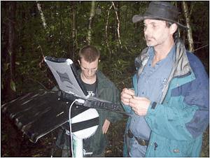
Downloading faunal biodiversity data
Peri-urban landscape in South-East Queensland
The SEQ Peri-urban Supersite was established under TERN in 2010. It provides extensive new research infrastructure for scientists to determine if key ecosystem services such as high-quality water can be maintained in a rapidly urbanising environment. The supersite comprises one node north of Brisbane City and two nodes to the south.
At the northern site, in the Samford Valley, the focus is on the study of terrestrial biogeochemistry managed by the Queensland University of Technology (QUT) through the Samford Ecological Research Facility (SERF). The southern-most site, in the catchments of the Logan and Albert Rivers, has a strong aquatic biogeochemistry focus; it is managed by CSIRO. The third node, Karawatha Forest, has a biodiversity focus and is managed by Griffith University.
Researchers at Samford want to understand the implications of land use and land management on the biophysical interactions that control greenhouse gas emissions. They have deployed an automated greenhouse gas sampling unit to collect high temporal-resolution CO2, CH4 and N2O emissions from native woodlands and peri-urban grasslands. The Samford node is also part of the OzFlux network, and an eddy co-variance station installed on grassland there measures the exchange of CO2 and water vapour between the grassland and the atmosphere This will help to quantify the impact of different land-use systems on the carbon and water balances in the Samford Valley.
In the Logan River and Samford Creek, high-frequency biogeochemical and ecological studies are under way to help scientists understand why they contribute such high loads of nitrogen and sediment into Moreton Bay. (Logan River flows directly into the bay, and Samford Creek reaches it via the Pine River.) Permanent measurement stations have been established at both nodes to provide continuous water quality and flow data. The stations consist of physico-chemical sensors to measure temperature, pH (degree of acidity or alkalinity), Eh (the redox, or reduction-oxidation, character of the water), and conductivity; and a velocity Doppler to measure river flow and height. These measurements will help researchers to quantify land-use change.
Continuously recording acoustic sensors have been deployed in Karawatha Forest and at SERF to measure species richness of birds and, potentially, frogs.
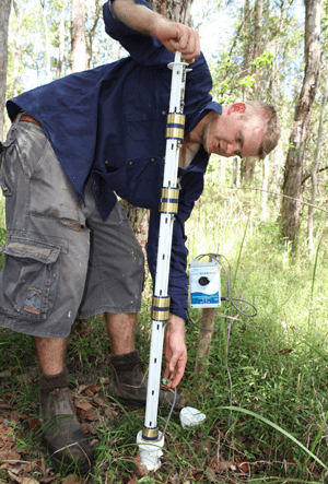
Dr David Rowlings with a soil moisture sensor in the
SERF woodland
Mediterranean woodlands of southern Western Australia
The newest supersite in the network is in the Great Western Woodlands (as reported in the November issue of the newsletter). CSIRO Ecosystem Sciences and the Department of Environment and Conservation WA (DEC) are leading the establishment of the site, which extends into the adjacent wheatbelt region.
Researchers working here aim to find solutions to land-management problems in agriculture, mining, pastoralism and biodiversity that are nationally and regionally significant.
A focus of the supersite is the OzFlux station at DEC-managed Credo Station near Kalgoorlie. It will be used to monitor the energy, water and carbon balance of mature semi-arid eucalypt woodland that is representative of natural landscapes in this region. Preparations for installing the flux tower are under way.
Other projects in progress are the establishment of vegetation monitoring plots along a gradient that marks different times since fire last occurred in gimlet (Eucalyptus salubris) woodland, and plant physiological monitoring in different woodland types on Credo.
Why these woodlands? The 16 million hectare Great Western Woodlands region is extraordinary because it has remained relatively intact since European settlement, owing to the variable rainfall and lack of readily accessible groundwater for livestock. This gives it international significance. As most other temperate woodlands around the world have become highly fragmented and degraded through agricultural use, the GWW offers a unique opportunity to understand how intact woodland landscapes function. The region is also unique because it is the only place where woodlands of more than 20 m tall occur in such a dry climate — the mean annual rainfall here is as little as 250 mm.
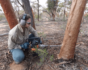
Estimating fire age in gimlet woodland
Published in TERN e-Newsletter December 2011