Thanks to a new partnership between TERN, CSIRO and Google, detailed satellite imagery about Australian landscapes will soon be available through the Google Earth Engine.
The Google Earth Outreach program was officially launched in Australia and New Zealand on 5 November. Already operating in a number of locations around the world, the program gives non-profit and public-benefit organisations the knowledge and resources they need to visualise information and share spatial information using Google Earth and Google Maps.
Researchers from TERN’s AusCover facility worked behind the scenes with Google in the lead-up to the outreach launch in order to make some of their landscape monitoring tools accessible through the Google Earth Engine. This work was featured as part of the Google Earth Outreach launch, and also attracted widespread media attention.
According to AusCover Director Dr Alex Held, the partnership with Google will provide greater access to and international reach of Australian science.
‘Researchers working with TERN and CSIRO will be able to use Google’s enormous cloud computing power to contribute their expertise and environmental data to deliver easy-to-use maps and tools for millions of users world-wide,’ Alex says.
The first of the new data tools are being tested in Google Earth Engine and are due out early next year. Combined with data already freely available via the TERN Data Discovery Portal and CSIRO, the Google Earth Engine will provide unprecedented capability in the use of satellite observations for all sorts of environmental management, conservation and landscape science projects.
After the launch, Google hosted a two-day workshop in Sydney and gave 75 attendees from a number of organisations a chance to explore the outreach platform with training from Google engineers.
Dr Peter Scarth from AusCover was there, and he described the workshop as a unique event, focussed on the use of spatial data to promote public good.
‘It was tailored to getting an overview of many of the key Google geo-tools, and then focussing in on the tools of interest and direct relevance to my research needs,’ he says. Peter was also invited to present some of AusCover’s Earth Engine work to help other workshop attendees see the potential of using the Google framework.
Peter says: ‘I really appreciated the opportunity to present some of our work to the other participants. Now, moving on from the workshop, we’re exploring ways to build on some of our initial Earth Engine algorithms to start extracting information at finer scales, and also looking at trends in environmental variables. Watch this space.’
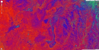
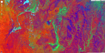
Ground-cover estimates for the Diamantina River, determined by AusCover and shown in the Google Earth Engine. The AusCover fractional-cover algorithm uses satellite images to estimate the proportion of bare ground (red), green vegetation (green) and non-green vegetation (blue) in each pixel. The left-hand image (a) shows the region in 2006, a particularly dry year when there was little green or dry cover. The right-hand image (b) shows the same landscape in 2007 following floods that resulted from cyclone run-off, when the river channel has come to life. Estimates of ground cover and observations of its change over time provide land managers, policymakers and scientists with valuable information for addressing environmental management issues.
Published in TERN e-Newsletter November 2012
