This month we’re pleased to hear from Claire Harris at our partner organisation CSIRO, about dust storms and the collaborative work TERN’s AusCover Facility and its partners are doing to mitigate their impacts.
Residents of South Australia, Victoria, New South Wales and the ACT will be all too aware of the uncomfortably strong winds that have accompanied the recent record breaking heatwave. Wind can sometimes result in significant soil erosion and dust in the air. Dust can be bad for our health, ecosystems, agriculture, transport, our infrastructure and ultimately our economy (although Marjory from Little Britain might disagree as she rolls out her diet programs).
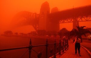
Few of us could forget the dust storm in September 2009, which famously blanketed Sydney in a bright orange hue. The urban costs of this storm were estimated at $300 million (Photo courtesy The Age).
One way to understand the risks of dust storms is to marry weather forecasts with the potential dust sources across the country and see if they are going to meet up.
Dr Juan Pablo Guerschman, a CSIRO Research Scientist and collaborator in TERN’s AusCover Facility, has been working with colleagues in and with funding from the Australian Government Department of Agriculture, state and territory governments to deliver Australia’s dust and ground cover monitoring expertise.
‘Using satellite products we can estimate landscape properties of interest across the Australian continent like the proportion of the land that is covered by vegetation – either green or dry – or is bare soil.’
‘When there’s windy weather, it means that there’s a risk of dust storms and erosion of our soil and so particularly in spring we know that our data products will be in demand.’
Every eight days a new image comes through from an imaging sensor called MODIS attached to two NASA satellites. Juan and team have developed a system that takes that satellite information, runs it through mathematical calculations and delivers information about ground cover through the AusCover portal and served via the National Computer Infrastructure. This is then picked up by data users such as the Community DustWatch program to assess where there might be sources of dust.
The DustWatch program tracks wind erosion across Australia and produces a range of maps and products for use by governments and land managers and to warn agencies monitoring air quality of incoming dust storms.
Estimates of ground cover and observations of its change over time provide land managers, policy-makers and scientists with valuable information for addressing a range of environment management issues.
Dr John Leys, Community DustWatch Coordinator, says that by combining weather station information, indicating the wind direction, with the CSIRO ground cover information from the AusCover portal they can look for possible sources indicated by bare ground. Dr Leys and his team then connect with their network, sometimes by phone or by email, to find out what is happening in that area.
‘This data from CSIRO has provided significant benefit to us. We can now get very quick spatial understanding of the landscape to see where bare ground might be a source of dust. When dust is measured in the DustWatch network of instruments, we can quickly find out where the dust is coming from.’
‘The dust storm that occurred last Tuesday (24th September 2013) originated from two source areas, Lake Eyre and another area with low ground cover that has been caused by an increase in feral animals.’
‘This information from CSIRO is the most rapidly-available data in Australia and it is critical,’ Dr Leys said.
According to Dr Leys ground cover in the rangelands of Australia has reduced during 2013. Many areas have lost a substantial amount (about 30 per cent) of ground cover. This has been due to lack of rain, extremely dry temperatures and higher feral animal numbers.
So we might be in for a long, dusty summer…
Beyond dust-watching this type of research is also useful in Australia, for example, managing grazing and other land management practices and tracking our carbon budgets.
But the work doesn’t stop there. The AusCover team continues to explore new opportunities for using remote sensing technologies to monitor ground cover. For example, in a new pilot project several small, compact and wirelessly networked sensors are being installed across the landscape to measure light levels, temperature, humidity and soil moisture to monitor the drying of a landscape at a greater level of detail than ever before.
Dr Alex Held, AusCover Director, will speak about this initiative and other AusCover projects at the upcoming ‘Science of Extreme Events’ public briefing.
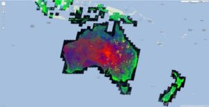

Ground cover estimates from fractional cover data available via the AusCover data portal. Blue and red areas means ground is exposed and more at risk of erosion and green areas covered by vegetation.
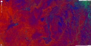
%20DiamantinaRiver2006.jpg)
Ground cover estimates for the Diamantina River region, as determined by AusCover and shown in Google Earth. The fractional cover data uses satellite images to estimate the proportion of bare ground (red), green vegetation (green) and non-green vegetation (blue). The image above shows the region in 2006, a particularly dry year when the landscape was very bare, with little green or dry vegetation cover. In contrast, the image below shows the same landscape in 2007 following flood events resulting from cyclone runoff, when the river channel has come to life.
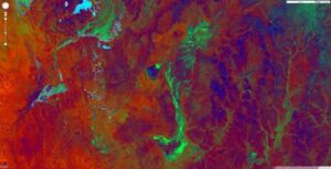
%20DiamantinaRiver2007.jpg)
Published in TERN newsletter January 2014
