Better integration of Earth observation data into environmental models is critical to our ability to understand, predict and address complex global sustainability challenges and realise significant societal benefits. We reflect on an energetic discussion on this topic at GEO Week 2019 and the opportunities that arose from it.

How can scientists model Earth’s complex systems and make sense of measurements from Earth Observation (EO) technology to answer important questions for society? Can they learn from one another’s different ‘fit-for-purpose’ methods? And what can they learn from other domains like design, engineering, art and social science to address complex global challenges?
Recently, an international panel of Earth system scientists and modellers, including collaborators with NCRIS-enabled projects AuScope and TERN discussed these questions in GEO Week 2019 in Canberra.
The group of scientists, who represent geoscience, environmental science and engineering domains, employ different methodologies to address challenges over different time and spatial scales. These include models that explain the state of the natural environment (Earth System Models), models that use artificial intelligence (AI) to quickly categorise geospatial data (Machine Learning Models), and models that use systems thinking to simulate interactions between human and natural systems (Complex System Models).

Discussion
Leading the discussion, Assistant Professor Danielle Wood, Director of the Space Enabled Research Group within the MIT Media Lab, explained how her Space Enabled Research Group pursues projects using all three types of models — Earth Systems, Machine Learning and Complex Systems — alongside partners from regions around the world.
The Space Enabled Research Group is pursuing projects to apply satellite-based earth observation technology to support coastal water ecosystem management and urban development in Benin, Ghana, Tanzania and Brazil, in collaboration with local government or university partners.
In their work, the Space Enabled Research Group uses Machine Learning models to categorize the observations of long term historical datasets for important ecosystems such as mangrove forests, in collaboration with partners from NASA Goddard Space Flight Center. They also build Complex Systems Models to analyze how people are influenced by the health of coastal environments and to estimate how human decisions for environmental management, such as preserving mangroves or removing invasive plants, impacts the health of ecosystems.


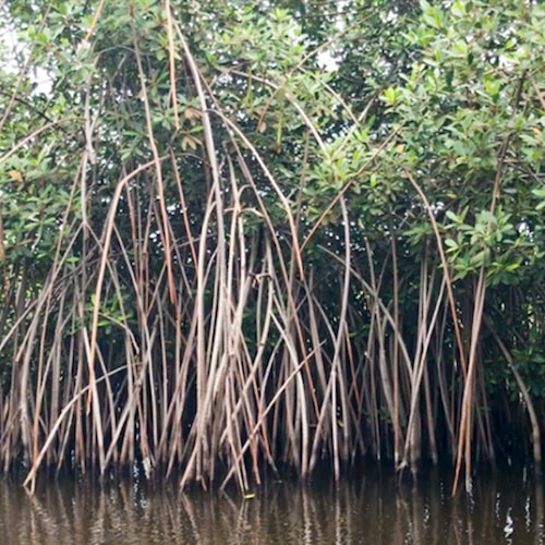
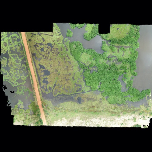
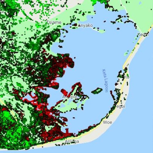
Danielle and her team have been working to understand deforestation in West Africa, and help governments and non-profit groups find a balance between using mangrove wood for fuel and allowing it to regenerate and support aquaculture in vulnerable communities. Images (L—R) show a mangrove forest, an aerial map of mangroves produced by drone imaging, and a google map highlighting areas of relatively severe deforestation (red) that was produced using AI-coded satellite data (Images courtesy of Danielle Wood)

Panellists then presented lightning talks on their work using different modelling methods:
- Dr Robert S. Chen from The Earth Institute, Columbia University discussed his work with Facebook's Data for Good Program, NASA and GeoCollaborate to estimate population and demographics in remote areas to assess infrastructure needs
- Anastasia Wahome from the Regional Centre for Mapping of Resources for Development in Kenya discussed SERVIR Eastern & Southern Africa’s work using EO data to model floods and streamflow due to climatic changes in Eastern Africa to support flood vulnerable communities and for sustainable agricultural water use.
- Dr James Cleverly from the University of Technology Sydney discussed TERN’s collection and provision of model-ready environmental data across Australia for earth systems and climate models, and global satellite data calibration and validation.
- Dr Narendra Kumar Tuteja from Australia’s Bureau of Meteorology discussed how water forecasts are helping Australia manage water scarcity and environmental sustainability using global earth system observations, statistical models, dynamic models and even human behaviour models.
- Dr Rebecca Farrington representing AuScope discussed her work to simulate historical groundwater, rift basin and mantle convection dynamics in deep time using Underworld.
- Dr Sara Morón representing the Basin Genesis Hub discussed her work using AuScope funded software to model the formation and evolution of basins and river networks in deep time as they host mineral, energy and water resources that are critical to society.

Reflection
To the panellists’ delight, a near-full room of scientists listened closely and asked questions about how ‘shallow’ and deep time interact; what challenges remain to further integrate detailed satellite data
into various models; and how scientists can best advance evidence-based policy.
Dr Sara Morón reflects on challenges for scientists working in deep time:
“One of the challenges of doing deep time modelling is that the geological record is temporally and spatially fragmented, there is great uncertainty about the initial conditions, and instead of forecasting the future we want to understand the processes that created the geological patterns that we see today.
Understanding of these processes is key for the sustainable extraction and management of resources.”


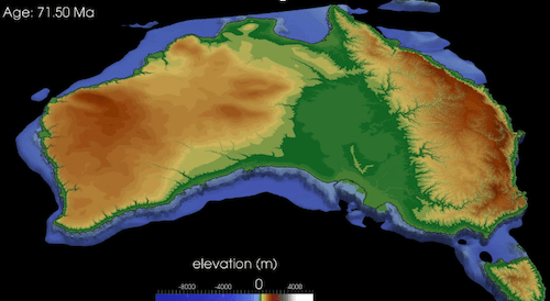
Snapshots from models of (tectonic plate) subduction zones (left) and paleotopography (right) in Australia using AuScope-enabled Underworld and Badlands software (Images courtesy of Dr Rebecca Farrington (left) and Dr Tristan Salles (right))
Dr James Cleverly reflects on the environmental research impact for ecosystem scientists and data providers:
“Advances in earth systems observations, science and modelling support the global communities. Conversations amongst data providers, modellers and remote sensing scientists are essential for identifying which measures are essential for models and which can be obtained with certainty.
These close relationships lead us down the track towards the creation of a national environmental prediction capability, which presents an opportunity to improve Australia’s ability to manage complex challenges such as floods, droughts, water resources, food and energy.”

And, to close, Assoc Prof Danielle Wood reflects on technical and policy challenges for the modelling community:
“This panel discussion shows how scientists that build models have been learning effective
ways to collaborate with engineers to build tools to collect observations of the earth and to understand long term earth system dynamics.Scientists must increasingly coordinate with policy makers and communications professionals to share the findings from models that describe the environment.
Our next exciting opportunities are to learn how to combine the strengths of complex systems models, Earth system models and artificial intelligence to inform policy making to manage the environment while considering human welfare.”
- Do you have ideas about how a National Environmental Prediction System should be designed and ways in which it might be used? TERN invites you to help shape the development of this key support system for Australia’s research and decision-making communities. How you can be involved:
- Read the NEPS System Design
- Participate in one of the Town Hall Meetings in February 2020
- Make a written submission to the NEPS Scoping Study
Interested to Learn More?
For more information on TERN’s Landscape Monitoring Portal or our Environmental Monitoring Systems, please reach out to our team on (07) 3365 9097, via our email on tern@uq.edu.au or through our contact us page.


