International Partnerships
TERN infrastructure and data are used by researchers to investigate a great diversity of ecosystem questions. TERN therefore intersects with a number of international communities of practice in a range of disciplines. TERN people are engaged with international interest groups to:
- ensure that Australian ecosystem research is well-represented in Australia, in our region (South-East Asia) and globally
- contribute to global discourse on current and emerging ecosystem knowledge
- promote TERN Infrastructure and data – and their availability to all researchers
- exchange ideas with affiliated peak bodies and track current practice in other countries
- support evidence–based decision making on management of ecosystems and landscapes
TERN data are increasingly being used in multi-region and multi-discipline research, particularly in climate science. We expect that large-scope research programs looking at complex processes and change at global/regional scale will become common.
On this page:
Global Ecosystem Research Network (GERI)
The Global Ecosystem Research Infrastructure (GERI) is an integrated network of site-based research infrastructures dedicated to better understand the function and change of indicator ecosystems across global biomes to support excellent science that can also inform political and managerial decision-making addressing grand societal challenges.
TERN is a founding member of GERI.
It is envisioned that a fully functioning GERI will deliver the harmonised data, international partnerships and enable new understandings of global ecological processes—stretching across continents, decades, and ecological disciplines—in ways that were not previously possible.
By bringing together these infrastructures, for the first time in history, we now have the infrastructure capability to ask environmental research questions with both societal and scientific importance across and among continents.
The GERI’s capabilities are vital to better address future, critical challenges for the sustainable management of our limited natural capital under known environmental change, and future, yet unknown environmental challenges to assure long-term human well-being on the planet.
The managing institutions that operate six different continental-scale ecosystem observing infrastructures, from Africa, Asia, Australia, Europe and North America (two from Europe), signed a landmark Memorandum of Understanding (MoU) on Tuesday 8 December, 2020, expressly committing to the development of GERI.
Environmental Research Infrastructures | Host country/continent | Shareholder/sponsor/funder |
China / Asia | Chinese Academy of Science | |
European Long Term Ecosystem, critical zone and socio-ecological systems Research Network (eLTER) | Germany / Europe | European Commission |
Finland / Europe | European Commission | |
USA / North America | National Science Foundation | |
South Africa / Africa | National Research Foundation | |
Australia / Australia | National Collaborative Research Infrastructure Strategy |
Current participating Environmental Research Infrastructure (ERIs) in the Global Ecosystem Research Infrastructure (GERI) project. Please note that the Shareholders/Sponsors are NOT signees of the MOU.
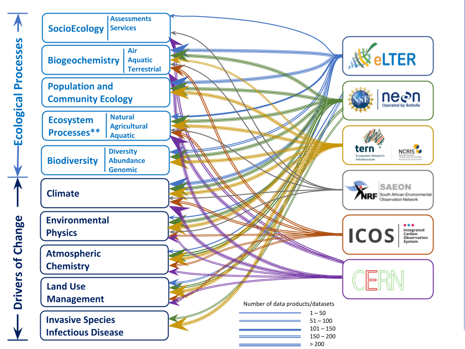
This is a conceptual Landscape map that demonstrates the collective suite of data that makes up the GERI. The data suites (fields) provided by the GERI-member Environmental Research Infrastructure are mapped against the drivers of changes (cause) and the ecological processes (effect). Each ERI is color coded with weighted lines that quantitatively indicates the number of data products/sets and the data suites they contribute towards the GERI.
Group on Earth Observations (GEO)
GEO is an intergovernmental partnership working to improve the availability, access and use of open Earth observations, including satellite imagery, remote sensing and in situ data, to impact policy and decision making in a wide range of sectors.
Asia Oceania GEO is the regional forum that brings together the GEO community in the Asia-Oceania region to exchange scientific and technical knowledge on Earth observations and their applications for regional and global priorities.
GEOBON and APBON
The Group on Earth Observatories Biodiversity Observing Network (GEOBON) is the international network of national or regional ‘BONs’.
TERN represents the Australian ecosystem science community in the international GEOBON network through participation in the Asia-Pacific Biodiversity Observation Network (APBON) – one of six GEOSS AP task groups that play a significant role in strengthening regional cooperation for the SDGs, Paris Agreement and Sendai Framework.
Some key groups in the Pacific region are gathering support for others to join them in scoping the feasibility of recognising and uniting a range of existing country-level monitoring projects in the region as the basis of an integrated BON in the Oceania region. Contact us for more information and to get involved.
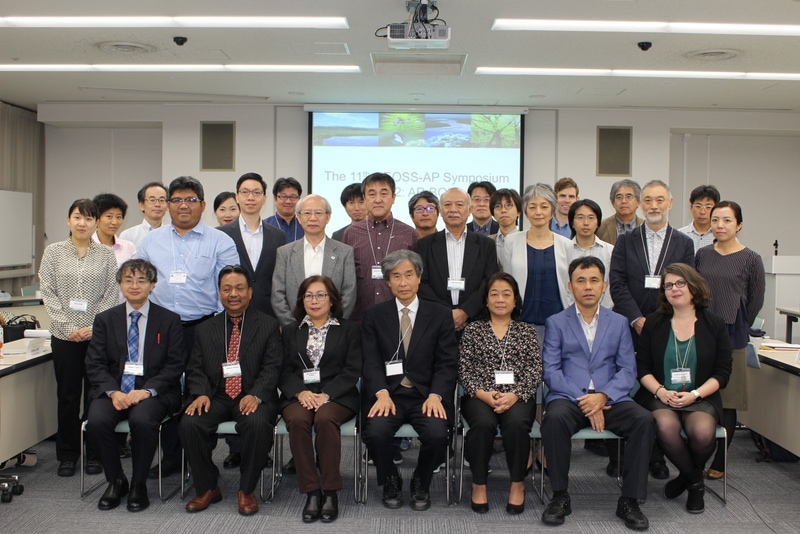
Participants of the Asia-Pacific Biodiversity Observation Network (APBON) at the 11th GEOSS Asia-Pacific Symposium, which was held in Kyoto from 24 to 26 October 2018 by GEO and Japan’s Ministry of Education, Culture, Sports, Science and Technology (MEXT) (image courtesy of Biodiversity Center of Japan)
International Long-Term Ecosystem Research (ILTER)
Long-term researchers occupy a unique space in the research landscape, primarily due to the disconnect between the inherent level of time commitment—in research that can span a lifetime—and the increasing uncertainty of ongoing funding. This is despite the fact that almost everyone accepts the value and importance of long-term studies.
Feedback from the International Long-Term Ecological Research (ILTER) network indicates that Australia is leading the way in many areas of long-term research infrastructure provision and data capture. It also suggests that we share some of the challenges of ensuring national and global collaboration for site registration and use of data.
Australia currently has 26 long-term ecological research sites registered by the global peak body’s site database (ILTER DEIMS-SDR). However, we know there are many more long-term ecological and agricultural research sites in Australia.

AusLTER
TERN, the Ecological Society of Australia (ESA) and the Ecosystem Science Council (ESC) are working together to provide the Australian long-term ecological research community (AusLTER) with a means to collaborate, meet and discuss strategies and structures that will position the community to work together locally, nationally and internationally.
TERN’s role as the national ecosystem observatory, and hence Australia’s lead on environmental research infrastructure initiatives, is to represent AusLTER on the Coordinating Committee of ILTER and continue to pay Australia’s annual membership fees to ILTER.
ESA is committed to facilitating a neutral, inclusive and safe space for this community of practice to determine a way forward and is consulting with the AusLTER community to identify their wishes and needs for support for an AusLTER community.
TERN, ESA and ESC are working to reinvigorate AusLTER, one of the founders of ILTER. A stronger AusLTER, with one or more special interest groups, will enable Australian long-term ecosystem researchers to have an annual workshop and coordinate to seek collaboration opportunities internationally with other ILTER members.
Site accreditation in DEIMS-SDR
Get noticed! Register your research site on an international database
DEIMS-SDR (Dynamic Ecological Information Management System – Site and dataset registry) is an information management system powered by eLTER. It allows you to discover long-term ecosystem research sites around the globe, along with the data gathered at those sites and the people and networks associated with them.
DEIMS-SDR describes a wide range of sites, providing a wealth of information, including each site’s location, ecosystems, facilities, parameters measured and research themes. It is also possible to access a growing number of datasets and data products associated with the sites.
One of the benefits Australian long-term ecologists receive from participating in the AusLTER community of practice is a subscription to DEIMS-SDR. AusLTER participants can choose to have their research sites listed in DEIMS-SDR
Site listing in DEIMS-SDR lets others in the world know about your long-term ecological research site, enhancing opportunities for collaboration and data re-use.
Registration in DEIMS-SDR is invited from all Australian long-term researchers. The first step is to read the information at right, then contact us for more information on how to register.

Members of the AusLTER community of practice at a workshop in Brisbane in 2018
DEIMS-SDR: Overview of functionality and ILTER accreditation by Christoph Wohner, 20 July 2023.
AusLTER CoP webinar 5 September 2023 – registering sites in the international DEIMS-SDR database
FLUXNET
FLUXNET is the global data network of eddy-covariance research networks which aggregates the flux station data from its members, including TERN OzFlux, representing the Australia and New Zealand region.
Researchers working within regional networks process and analyse data, and then offer their data through regional network data portals. FLUXNET links these regional networks together, collecting their datasets to create processed and harmonized eddy covariance data products.
The most recent FLUXNET data product, FLUXNET2015, is hosted by the Lawrence Berkeley National Laboratory (USA) and is publicly available for download. Currently there are over 1000 active and historic flux measurement sites, dispersed across most climate spaces and representative biomes.
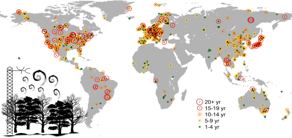
FLUXNET network map, 2021
OzFlux
OzFlux is the community of researchers who operate a network of ground-based ecosystem monitoring stations across Australia and New Zealand. The network consists of instrument towers that measure the energy, water and gas exchange – the flux – between the atmosphere and the ecosystem. In addition, the towers are weather stations, measuring air temperature, humidity and solar radiation. Measuring the flux reveals the workings of ecosystem processes.
A group of twelve Australian and New Zealand universities, plus CSIRO and the Manaaki Whenua Landcare Research institute, manages a total of 28 active and 15 inactive OzFlux stations.
TERN funds and supports OzFlux. OzFlux is a very important southern hemisphere link in FLUXNET.
OzFlux’s 20+ year data series is now yielding answers to key ecological questions. This includes whether ecosystem sequestration is feasible. Professor Jason Beringer and Research Fellow Dr Caitlin Moore, both from the University of Western Australia’s School of Agriculture and Environment, led a large team of researchers contributing to a major paper, published in Global Change Biology in March 2022.
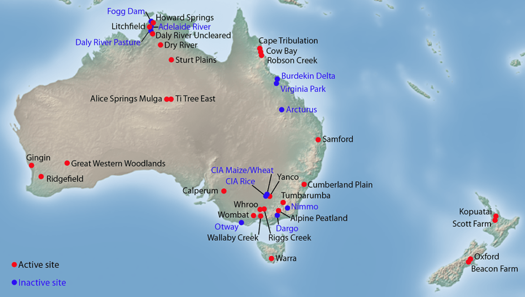
OzFlux network map, 2021
Cosmic-ray soil moisture monitoring network (COSMOS)
The COSMOS soil moisture network is the global collection of stationary cosmic-ray soil moisture sensors. The sensors provide, almost in real time, measures of soil moisture averaged over about 20 ha and, depending on conditions, to a depth of 10 cm to 40 cm.
With funding from the Australian Government’s NCRIS Investment Plan and the Queensland Co-investment Research Infrastructure Fund (RICF) grants and CSIRO, Australia is part of the global COSMOS network via TERN’s CosmOz network.
Australians can benefit from precise soil moisture data, which is becoming increasingly valuable in understanding ecosystem function and in areas such as agriculture and forecasting floods and other natural disasters.
Other member networks are found in USA (COSMOS), UK (COSMOS-UK), Germany, South America and Africa.
CosmOz
The CosmOz website lets users visualise then download open-source soil moisture and rainfall data from a growing number of sensors.
The Australian CosmOz soil moisture network has 14 sites providing live data streams (Aug 2023). A further 11 sites are currently inactive.
Sensors are often colocated at TERN SuperSites, including Great Western Woodlands in Western Australia, Alice Mulga and Litchfield Savanna in the Northern Territory, Mitchell Grass Rangeland in Queensland, and Warra Tall Eucalypt in Tasmania.
Sensors are also at the Boorowa Research Station outside of Canberra and in Queensland’s Brigalow Belt, one of Australia’s most significant biodiversity hot spots and a key site to contrast long-term agricultural use with the original forest.
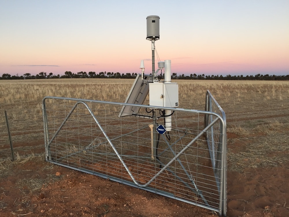
A CosmOz sensor in an agricultural landscape near Birchip, Victoria

Map of CosmOz Sensor locations, August 2023
Global PhenoCam Network
The PhenoCam Network is a cooperative continental-scale phenological observatory that uses imagery from networked digital cameras to track vegetation phenology in a diverse range of ecosystems across North America and around the World.
The network was established in 2008 and currently includes over 700 sites. The image archive includes over 60 million pictures.
Data from PhenoCam can be used for phenological model validation and development, evaluation of satellite remote sensing data products, benchmarking earth system models, and studies of climate change impacts on terrestrial ecosystems.
Australian PhenoCam Network
A nation-wide network of phenocams has been installed by fellow NCRIS projects, TERN and the Australian Plant Phenomics Facility, at TERN SuperSites around Australia.
This network of cameras forms part of a larger network called the Australian Phenocam Network, which, together with the TERN EcoImages portal are making huge amounts of time-lapse image data accessible to scientists studying seasonal vegetation changes and carbon dynamics.
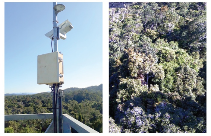
The phenocam (left) was installed on the flux tower at TERN’s Robson Creek SuperSite in Far North Queensland in late September 2019 and streams time-series photographic data (right) to a central data storgage and processing platform (images courtesy of Mirko Karan)