
This month we’re travelling to the wheatbelt region of Western Australia to visit TERN’s Boyagin Wandoo Woodland site and its paired Ridgefield Farm OzFlux site. Together, the sites’ automated environmental monitoring infrastructure provide essential long-term continuous data to understand landscape dynamics in this biodiverse swath of Australia valued at almost AU$3 billion.
TERN’s Boyagin Wandoo Woodland SuperSite is located in remnant Eucalyptus wandoo woodland within the Boyagin Rock Nature Reserve, about 175 km southeast of Perth, Western Australia (WA). Monitoring of the Wandoo woodland ecosystem is paired with a nearby managed ecosystem located at the University of Western Australia (UWA) Ridgefield Future Farm that’s used for wheat and canola cropping and sheep grazing.
The NCRIS-enabled TERN Boyagin SuperSite is operated by UWA’s Prof. Jason Beringer, Dr Caitlin Moore and Tim Lardner with support from the Western Australian Government.
A perfect pair of towers monitoring diverse ecosystems
The Boyagin Wandoo Woodland SuperSite and Ridgefield OzFlux site are located approximately 4 km apart, and provide an ideal pair of flux monitoring towers to help understand landscape dynamics in the WA wheatbelt.
The cropping and grazing systems of WA’s wheatbelt alone have been valued at around AU$2.7b, a figure that does not consider the ecosystem services value of the remnant pockets of biologically significant natural ecosystems, such as that at the Boyagin Wandoo Woodland SuperSite.
Monitoring equipment at the two sites quantify the exchanges (fluxes) of carbon, water and energy between the land and atmosphere and between the two different land use types. The data are used by researchers from across Australia to contrast how past, current and future climate variability is likely to impact these two ecosystems.
Watch the real-time changes
of fluxes and weather at:
Watch the real-time changes
of fluxes and weather at:
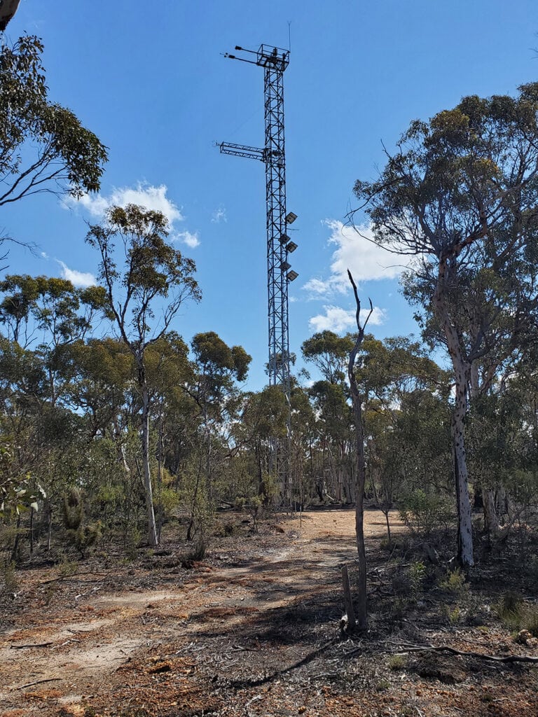
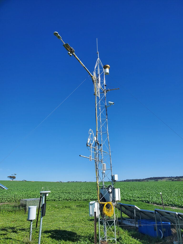
The TERN Boyagin Wandoo Woodland SuperSite (left) and the UWA Ridgefield OzFlux site (right) provide an ideal pair of monitoring towers to help understand landscape dynamics in WA’s wheatbelt (Credit: Caitlin Moore)
Monitoring life-sustaining ‘Critical Zone’ resources
The two monitoring sites are also included in Australia’s emerging Critical Zone Observatory (CZO), which has been funded by the Australian Research Council’s Large Infrastructure, Equipment and Facilities scheme (ARC LIEF) to create a new network comprising five core and five satellite monitoring sites in four states and the Northern Territory. The purpose is to sample the diversity of Australia’s geologies, biomes, land uses and climates.
State-of-the-art, automated monitoring sensors at the sites will record stocks and flows of carbon, water, energy and mass across the Critical Zone—the vertical span from plant canopies to fresh bedrock.
The information collected will fill essential knowledge gaps about interactions of under- and above-ground environmental processes and their responses to disturbance and change. These interactions ultimately determine the sustainability of food, clean water, mineral resources and Australian ecosystems, and allow the integration of existing environmental infrastructure monitoring with new sensors, methods and perspectives.
The funding will also support the development of a robust, long-term strategy for more effective and collaborative Critical Zone research, helping catalyse Critical Zone science in Australia and networking with a burgeoning international movement.
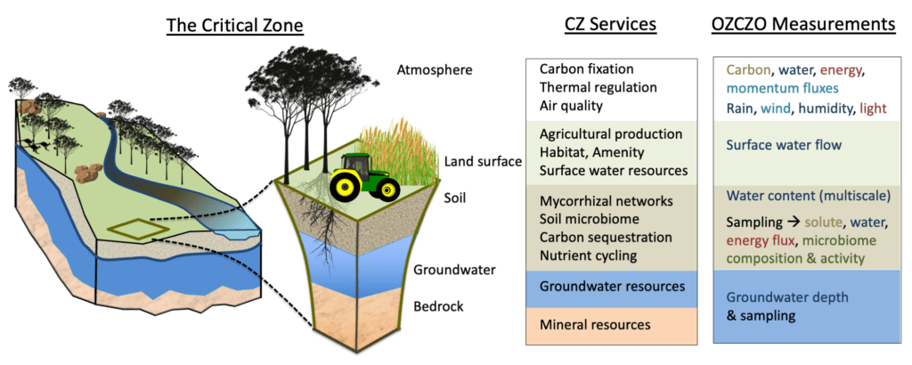
The critical zone (CZ) stretches vertically from bedrock to the atmospheric boundary and comprises bedrock, weathered/saprolitic rock, aquifers, soil, the rhizosphere and microbiome in the regolith, habitats, canopies and the nearsurface atmosphere. The CZ provides numerous life-supporting services. The Australian CZO network (OZCZO) will enable the integration of understanding across CZ zones, by measuring dynamics relating to water (blue), energy (red), mass (brown), and biotic processes (green).
Boyagin Nature Reserve – a place of cultural significance and unique biodiversity
Located in the Boyagin Rock Nature Reserve, the TERN Boyagin Wandoo Woodland SuperSite is located near (but outside of the flux tower footprint) a large granite outcrop called Boyagin Rock. This rock, also known as Boodjin, is a place of immense spiritual and cultural significance to the traditional custodians of the region, the Noongar People.
In the Noongar language, the rock gets its name from the term “Boya”, meaning rock or hard stone, and “djinning”, meaning looking or seeing – so it is the rock that sees.
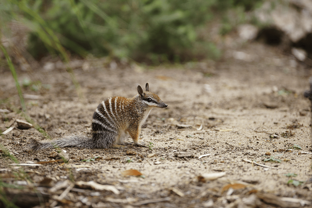
In addition to its cultural significance, the Boyagin Rock Nature Reserve is home to a significant community of rare plants and animals, many of which are endemic to the southwest region of WA. Among the endangered mammals is the numbat, a small termite-eating marsupial.
TERN’s wildlife acoustic sensing and camera traps at the Boyagin SuperSite are contributing towards monitoring the rare wildlife that lives in the reserve. And although not yet recorded by the TERN camera trap, numbats have been spotted near at the site – the video evidence from UWA researcher Tim Lardner is below!
Improving ecosystem stress detection at Boyagin and Ridgefield
An emerging issue facing the wheatbelt region is the prediction of a hotter and drier future climate. Boyagin and Ridgefield typically experience mean maximum daily temperatures from 15.3 °C in winter to 31.9 °C in summer. Dr Caitlin Moore from UWA says that Boyagin and Ridgefield sites tell an interesting story about ecosystem stress and how the two ecosystems mange it.
“Data from the last three years of measurement at the sites show the energy balance at both sites is dominated by sensible heat flux, which is reflective of the annual dryness of the wheat belt region. It is only during the winter months that sensible and latent heat flux converge.
Fortunately, this is when the winter wheat and canola cropping systems are planted. However, changes in the timing and duration of winter rainfall events increases the likelihood of water related stress in both ecosystems. Likewise, if summer temperatures rise this will increase the likelihood of heat related stress, particularly for Boyagin and for Ridgefield when under a grazing rotation.”
Dr Caitlin Moore, University of Western Australia
NOTE: latent and sensible heat fluxes are energy types. Latent heat is measured during changes in the phase of a substance, such as solid, liquid and gas. Sensible heat is that which we feel, e.g., between a warm surface and cool atmosphere.
To quantify the response of vegetation stress faster in these critical ecosystems, an exciting new biodiversity monitoring capability for Western Australia, has enabled the installation of state-of-the-art monitoring infrastructure.
Solar-induced chlorophyll fluorescence (SIF) sensors have been installed to measure the signal emitted from leaves during photosynthesis, which can be linked with plant stress.
“Our aim with this new equipment is to test how well SIF can be linked with ecosystem productivity in Australia and whether it provides a better indication of ecosystem stress than other vegetation indices that rely on changes in greenness to indicate stress.”
The new project and its equipment have been made possible thanks to co-investment in NCRIS-enabled TERN from the Government of Western Australia and co-contributions from The University of Western Australia (UWA), Edith Cowan University (ECU), CSIRO, and the WA Department of Biodiversity, Conservation and Attractions (DBCA).
With an eye to future expansion, the capability will also serve as a pilot study for an Australia-wide biodiversity monitoring framework that could be rolled out nationally by TERN.
- Click here for more information on the Boyagin Wandoo Woodland SuperSite
- Click here for more information on TERN’s Australia-wide network of ecosystem processes monitoring SuperSites.
- TERN’s network of sites is well equipped with a huge variety of monitoring devices to measure ecosystem change across the continent. TERN welcomes co-use of sites by researchers.