Almost all of Australia’s vegetated landscapes have been affected by changes in land-use and land-management practices. The continent is now a diverse mosaic of fragmented and modified native vegetation, and converted and replaced vegetation cover types. Compiling a record of the responses of plant communities to land-use changes would assist land managers make improvements in their practices to meet wider social, economic and environmental goals.
However, documenting the historical and contemporary use and management of a site and assessing the effects on vegetation condition is a complex task. The absence of a consistent approach to reporting transformations of plant communities over space and time remains a source of contention – and even conflict – between those involved in conservation and protection, and those responsible for sustainable land use and management.
Richard Thackway was awarded a Sabbatical Fellowship from TERN’s ACEAS facility in 2011 to work on this problem. He is now producing a handbook designed to assist practitioners to compile historical and contemporary information on the responses of plant communities to human use and management. It provides a consistent national landscape observation guideline for recording, interpreting, and reporting on the site-specific transformation of native vegetation.
‘I’ve put together this handbook based on decades of lessons learnt in compiling and translating many different sources of information about case studies,’ says Richard. ‘It relies on credible published and unpublished sources of the historical record that describe where, when, and what changes in land-use and land-management practices were used to maintain, remove, replace or restore the vegetation, and the corresponding responses of the plant community.’
The responses of a plant community are evaluated using a hierarchical system to score changes in 22 indicators, representing the transformation of components of plant community condition, such as species composition, vegetation structure and regenerative capacity. Each year of the historical record is scored against a reference state for each indicator. The development of this system enables the transformation of landscapes, for example central Queensland’s poplar box woodlands, to be demonstrated over time.
Importantly, the handbook provides a framework that can handle the diversity of information required to make such a record, including land-use histories, remote sensing, and several branches of ecosystem science.
‘Much of the historic information is qualitative, compared to contemporary information, which is more quantitative. A challenge that this handbook helps overcome is the systematic compilation of information that is generally piecemeal, not easily discoverable, poorly organised, and to a large extent non-digital,’ Richard says.
The methods described in the handbook have multiple applications.
‘Obviously they can be used to assess the extent or condition of key vegetation assets, and track that over time. But possibly the most interesting application right now is how these methods can be used to prioritise investment in environmental programs, and then monitor and evaluate the outcome of the investment.’
For more information about the project or the handbook, you can email Richard or ACEAS Program Manager Alison Specht.
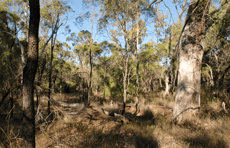
A. Reference: unmodified
Land use: minimal use
Management practices: protection, no grazing
Strata: multiple with some emergent
Biomass: 120 t/ha
Projected foliage cover: 52%
Maximum height: 24 m
Species per strata: over 3–5, mid 5+, ground 5–10
Regeneration: very good
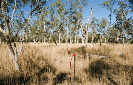
B. Modified
Land use: grazing native vegetation
Management practices: ringbarking and grazing
Strata: two normal height
Biomass: 68 t/ha
Projected foliage cover: 25%
Maximum height: 17 m
Species per strata: over 3, mid 1, ground 1–4
Regeneration: low to modera
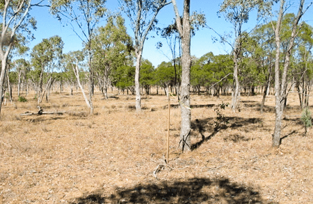
C. Transformed
Land use: grazing native vegetation
Management practices: mechanical tree removal and grazing
Strata: single – low height
Biomass: 42 t/ha
Projected foliage cover: 20%
Maximum height: 13 m
Species per strata: over 3, mid 0, ground 1–4
Regeneration: very low with bare ground
Transformation of poplar box (Eucalyptus populnea) woodlands in central Queensland. Land-management practices to promote cattle grazing have resulted in changes to the plant community. A is the reference site, in an unmodified state, B is a modified state, and C a transformed state. From historical records 1860–2012.
Published in TERN e-Newsletter August 2012
