A wealth of new ecosystem data will soon be available to the research community, after the successful completion of AusCover’s latest field campaign in Tasmania.
TERN’s AusCover, in collaboration with Airborne Research Australia, has just finished scanning the Australian SuperSite Network’s Warra SuperSite using an internationally unique combination of advanced airborne laser (LiDAR) systems.
The crew of the aircraft that scanned the forest, led by Dr Jorg Hacker, the Director and Chief Scientist of Airborne Research Australia, were in awe of what they saw and scanned.
‘The landscape there is absolutely amazing; basically a forest within a forest,’ says Jorg.
It was so dense that the supporting ground crew had considerable problems finding a location where enough sky was visible to be able to deploy GPS base stations, which are used to improve the accuracy of the survey.
The collaborative team scanned the forest with two types of LiDAR equipment (Riegl Q560/240 and Q680i-S) to provide the ecosystem science research community with ultra-high resolution imagery.
‘Each site was flown over between two and four times with each of the two scanners. Combining these gives us point densities of something like 100-200 points per square metre!’ says Jorg.
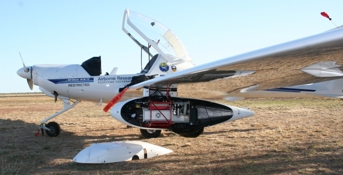
.jpg)
A laser scanner mounted in the underwing pod of Airborne Research Australia’s plane (Photo courtesy of Jorg Hacker)
Such high-resolution 3D airborne measurements of vegetation structure are critical for linking traditional ground-based plot measurements such as height, diameter, cover and biomass, to some of the satellite imagery products that AusCover provides.
The airborne datasets act as a vital intermediate step, enabling researchers to accurately scale measurements collected at a small number of ground plots up to broad satellite-derived landscape measurements of biophysical parameters.
By providing this unique combination of field, airborne and satellite data via the AusCover data portal, TERN’s infrastructure is already enabling and supporting a large number of important research projects.
This infrastructure is leading to the creation of new ways to do rapid and robust assessments of vegetation structure and biomass across large regions. One exciting example of this is the ForestLAS toolkit created at AusCover’s RMIT University-based node as part of the Cooperative Research Centre for Spatial Information Project 2.07. The toolkit makes use of LiDAR data to attribute forest canopy structure, with the eventual aim of producing a national map of the complexity of vegetation structure.
Furthermore, it is contributing to Australia’s involvement in international science programs, critically evaluating these technologies and global science programs such as the biomass and vegetation height maps being produced through AusCover for Japan’s Kyoto and Carbon Initiative.
Such products, in addition to the raw airborne LiDAR data that TERN has collected, will also help scientists from TERN’s eMAST facility model and understand how some environmental factors have changed during the period for which Australia has satellite images.
The data are also critical for researchers using flux data, collected via TERN’s OzFlux network, to measure biomass and quantify and manage fuel loads. The data, collected by Fugro in collaboration with ACT Parks and Conservation and the Australian National University, provide critical information for state agencies in Queensland and New South Wales, for mapping and monitoring vegetation structural properties.
Airborne LiDAR data are becoming an integral part of Australian ecosystem science and the infrastructure TERN provides is enabling researchers around Australia and the world to access it.
Airborne LiDAR data are currently available for download for nine sites around Australia via the AusCover data portal. Data from the Warra SuperSite campaign will be available after they have been analysed and the quality confirmed. Also keep your eye out for data from the Northern Territory’s Alice Mulga SuperSite, which is scheduled for scanning later this year.


A preliminary point cloud from a single overpass using ARA’s airborne laser scanner at the Warra SuperSite in Tasmania, showing the three dimensional forest structure – produced by ARA just two days after the flight. The maximum hight of the trees at the Warra SuperSite is approximately 60m.
PostscriptJorg made some other observations at the end of the trip that gave unexpectedly useful results in quite another direction. ‘When the team was ready to ferry the plane back to Adelaide after completion of the survey in southern Tasmania, the weather over Bass Strait had turned rather bad. So the only choice was to leave the survey aircraft behind and fly back by airline. ‘A week later the weather had improved and I travelled back to Hobart and flew the survey aircraft back to Adelaide, cruising at 5,000 m altitude with a 40 knot tailwind across Tasmania and Bass Strait. ‘After a refuelling stop at Mount Gambier, I decided to continue at just 500 m altitude, switched on the Q680i-S and scanned the whole length of the Coorong, from Kingston SE to Goolwa, about 200 km, and then the whole Adelaide coastline from Sellicks Beach to Outer Harbour, about 70 km, generating another 151 GB of raw high resolution LiDAR data!’ ‘It is also interesting to note that the whole survey trip, including all ferry flights and the survey itself, took approximately 17 flight hours, yielded about 800 GB of raw LiDAR data and the survey aircraft used just a bit more than 300 litres of premium unleaded fuel. ‘No other airborne platform in Australia comes anywhere near that efficiency and small environmental footprint.’ |
Published in TERN newsletter June 2014
