Discover the latest breakthroughs in environmental research infrastructure as 3 additional sites in TERN’s national monitoring network embrace state-of-the-art critical zone observing equipment. Explore the innovative Vadose-zone Monitoring System (VMS) and its potential to improve our understanding of how water, carbon and metal moves around ecosystems, manage grazing pressure and track the flows of industrial contaminants.
In a significant development for environmental science research in South Australia and Queensland, new state-of-the-art research infrastructure has been unveiled at 2 existing TERN sites and 1 new site. These now join the Western Australian Ridgefield site and New South Wales Wellington site as fully-equipped nodes of the TERN-supported Australian Critical Zone Observatories network (OzCZO).
The ‘critical zone’ is our planet’s outer layer, encompassing everything from the treetops to the bedrock, where all life is supported. It is an environment where rock, soil, water, air, and living organisms interact and shape the Earth’s surface.
South Australian – River Murray floodplains
The TERN Calperum Mallee SuperSite near Renmark is now fully-functioning as a Critical Zone Observatory site. Key critical zone monitoring additions to the site’s infrastructure which allow it to study the critical zone are a Vadose-zone Monitoring System (VMS), developed by Sensoil, and a new groundwater well. Further developments will occur in February 2024 when heat needles are installed. These measure conductive heat flow at the earth’s surface and are part of a collaboration with NCRIS-enabled AuScope.
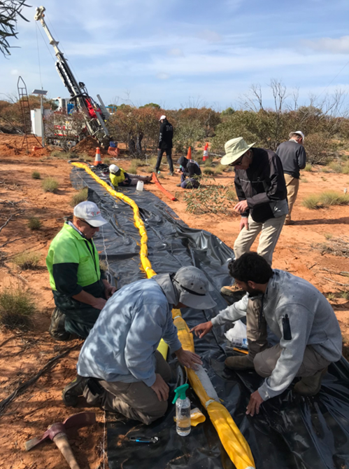
The recently installed VMS helps scientists keep an eye on the space between the Earth’s surface and the groundwater below—the vadose zone— to monitor hydrological and biogeochemical processes as well as elemental and nutrient fluxes in this space that are critical for life and local ecosystems. The VMS provides real-time, continuous data and enables the sampling of pore water and soil gases on-demand from the unsaturated zone, a critical area for understanding water and material movement and soil health.
Dr Juraj Farkas, Senior Lecturer and Isotope Geochemist at the University of Adelaide, explains how the VMS works and why it’s an important piece of kit.
"The VMS provides a unique set of tools and sensors that are located underground to help us monitor but also sample soil water and gases to better understand complex processes operating in the vadose zone. The VMS employs advanced sensor technology and sampling ports to collect and transmit data, providing researchers with a comprehensive view of the vadose zone's dynamics. It can measure things like water content, temperature, and other important data. It enhances the ability to monitor water, carbon and metal nutrients including their infiltration, transport, and biological uptake, which are all crucial factors in understanding the ecosystem and region's response to environmental change. The VMS is a game-changer for our research and sampling capabilities in this complex and highly dynamic space between a hard bedrock and the atmosphere, also called ‘critical zone’ that supports life. It's like having a secret agent underground, collecting information and key evidence (water and gas samples) to help us understand their sources and local cycling to make smart decisions about water and nutrient usage for sustainable and healthy ecosystem and future environmental protection. This is invaluable for studying how water, carbon and metal nutrients move through the critical zone and their influence on ecosystems, especially in arid and generally nutrient-poor regions like South Australia."
Queensland – Burdekin catchment
In Queensland, the ground-breaking VMS technology has been installed at the TERN Fletcherview Tropical Rangeland SuperSite inland from Townsville, and a site new to TERN at Petrie in the Moreton Bay region just north of Brisbane.
Dr Jamie Cleverly, Senior Research Fellow at James Cook University, says that the VMS system at Fletcherview, a fully functional cattle station operated by James Cook University for research and teaching, will allow scientists to gather real-time data to complement a range of ecological and agricultural studies. Some of these latter studies include the tracking of the life cycle (which is known as phenology) of savanna vegetation, acoustic records of bird and frog activity, monitoring of forage levels in the presence and absence of grazing, and measurement of water flow through trees as they transport moisture from the soil to the air.
"One of my favourite things about working on this project is the pleasant surprises. Before we began, no one could tell us if there was groundwater at the site, how deep it might be if it were there, or how deep is the bedrock. When we began drilling, we discovered that groundwater and bedrock were much nearer to the surface then we expected. Among a range of uses, data and samples collected at regular intervals will be shared with researchers and land managers, where they will be combined with data on soil and vegetation to help monitor ecosystem change and manage grazing pressure in the Burdekin River catchment, which has significant impact on the health of the Great Barrier Reef."
Queensland – Moreton Bay
Professor David Chittleborough of the University of the Sunshine Coast says that VMS tech at the new peri-urban Petrie site in South-East Queensland will be used to identify the movement and transformation of carbon, nutrients and colloids from the landscape which has had multiple uses, including industrial, urbanisation and forestry.
"Our research at the Petrie CZO site will not only help address the environmental challenges specific to the Moreton Bay region, but we’ll also be able to up-scale the findings to better understand issues of reforestation, urban encroachment and industrial activities on similar ecosystems."
The research infrastructure at Calperum, Fletcherview and Ridgefield also includes carbon, water and energy-monitoring flux stations, soil probes, groundwater monitoring wells, soil moisture sensors, biodiversity monitoring plots, and remote sensing technology. Similar equipment is set to be installed at Petrie in the coming year.
TERN’s data infrastructure is making the data collected by all these instruments and surveys openly available to researchers and decision makers around Australia and across the world to better understand ecosystem change and make management and conservation decisions.

- Access data from all TERN monitoring sites via TERN’s Data Discovery Portal
- Learn more about the Australian Critical Zone Observation Network (OzCZO) here
- The OzCZO team is Associate Professor Sally Thompson; Professor David Chittleborough; Dr Juraj Farkas; Professor Jason Beringer; Dr Andrew Marshall; Dr Jamie Cleverly; Professor Wayne Meyer; Associate Professor Martin Andersen; Dr Matthias Leopold; and Dr Martin De Kauwe.
- The ARC LIEF CZO project attracted additional funds via an AuScope Opportunity Fund (AOF) for a two-year project called ‘Laying the foundations for the Australian Critical Zone Observatories’ in which Electric Resistivity Tomography (ERT) and Seismic Refraction (SR) will be deployed at the five core CZO sites across Australia. At each, the aim is to determine (i) Depth to bedrock, (ii) Water table depth, (iii) Sedimentologic layering, and (iv) Characteristics of the weathering profile.
- OzCZO is being built as community infrastructure. Researchers are encouraged to use the infrastructure and the data streams being collected to support cross-site, cross-domain science. The OzCZO team would love to discuss ideas with you and support research proposals with access to OzCZO infrastructure.