News

Paddock to reef: Australia’s newest monitoring SuperSite

The TERN-Queensland Government project to introduce continuous environmental monitoring sensors into the Burdekin region is progressing well.  The new monitoring equipment will allow TERN to deliver essential measures on the ecosystem functioning of grazing landscapes and enable improved pasture modelling for Queensland and beyond. Join us as we check in on the site’s progress.

When we look at a map of where TERN’s infrastructure is located across Australia, there are some obvious gaps, including the north Queensland basin through which the Burdekin River flows —the river with highest discharge in the Great Barrier Reef catchment.

In addition to filling these gaps with many new vegetation and soil monitoring plots, co-investment in NCRIS-enabled TERN from James Cook University (JCU) and the Queensland Government, has allowed TERN to commence a three-year pilot project which will establish a high-tech monitoring SuperSite in the Burdekin.

New eddy covariance flux monitoring equipment will be placed at JCU’s Fletcherview Research Station, two hours west of Townsville.  Multiple autonomous monitoring sensors will be used to measure the exchange of water, carbon and energy between the atmosphere and the Earth’s surface 24/7.

Co-investment in NCRIS-enabled TERN from James Cook University (JCU) and the Queensland Government, has allowed TERN to commence a three-year pilot project which will establish a high-tech monitoring SuperSite on the banks of the Burdekin River in Queensland

Improved understanding of ecosystem function

The site of the new TERN SuperSite is used for cattle grazing. Black and red basalt soils and alluvial river flats support a wide variety of flora and fauna across open savanna woodland, dry rainforest, lava flows, three creek systems and the Burdekin River.

For TERN, the pilot project is an opportunity to obtain micrometeorological measures in an agricultural landscape, relatively uncommon in Australia, but much needed since research has shown that two thirds of Australia’s net ecosystem productivity (carbon uptake) is estimated to be from within annual ecosystems such as grasslands.

Grazed woodlands cover a huge part of northeast Australia, but the dynamics of these ecosystems—with respect to their carbon and water cycle—are relatively unexplored, says Professor Lucas Cernusak of James Cook University and TERN.

“We know they have potential to exert influence on the continental carbon budget through processes such as woody thickening, but we also know they are subject to pronounced climate variability, encroachment of invasive plant species, and changes in grazing system management that can have big impacts on ecosystem carbon and water fluxes.

The new TERN SuperSite observatory and flux tower at Fletcherview will give us a much-needed look beneath the hood to help us better understand the functioning of these systems, and how they might respond to a changing world.”

Professor Lucas Cernusak, James Cook University and TERN

The new site will form part of the TERN-OzFlux researcher community network with data contributing to the international FLUXNET dataset allowing regional and global analyses.

In early March 2021, a team of experts from TERN, JCU, CSIRO, University of Technology Sydney and the University of Southern Queensland spent two long hot days scoping locations to build the site’s flux tower.

Improved pasture models and estimates of safe stocking rates

University of Southern Queensland modeller and researcher Jo Owens is part of TERN’s team establishing the new national monitoring infrastructure and says that the data collected will significantly improve the modelling of large areas of grazing land in Queensland—80% of the total land use in Queensland.

“A critical gap in operational pasture modelling in Queensland is estimating tree transpiration and the water balance of areas with grazing land containing woody vegetation, which accounts for about 50% of total grazing area.

Data from this new TERN monitoring site will improve our understanding of how much water trees use, and the competition for water between trees and grasses. From this, we can estimate how much pasture biomass can be grown based on stored soil moisture. Better estimates of safe stocking rates can then be calculated.

Data from the new Supersite at Fletcherview will also be combined using modelling with long term data from other grazing trials in the region, such as the Wambiana Grazing Trial, to maximise the use and application of the data by the grazing industry.”

Jo Owens, University of Southern Queensland

Measurements from the site will help deliver improved predictions for existing Queensland Government modelling programs such as the operational pasture and drought modelling program delivered through the Long Paddock project.

Data will also contribute to the Paddock to Reef program, which is used for evaluating and reporting progress towards water quality targets under the Reef 2050 Water Quality Improvement Plan.

Left to right: Lucas (JCU), Joe Holtum (JCU), Peter O’Reagain (Queensland Government Department of Agriculture Fisheries and Forestry), and Martin Holzwart (JCU),

Sky high down to Earth

In addition to tower-mounted environmental measuring equipment, the new site will include multiple one-hectare soil and vegetation monitoring plots.  These plots will form part of TERN’s Australia-wide network of >700 ecosystem surveillance monitoring plots from which detailed vegetation and soil data and field samples are made available.

The Fletcherview SuperSite will join Australia’s newly announced Critical Zone Observatory network as a satellite site.  Additional co-located monitoring equipment will measure the water balance of the system from bedrock to groundwater and surface water to the treetops across the site’s diverse natural and agricultural settings.

Alice Mulga SuperSite​

Located on Pine Hill Cattle Station 200km north of Alice Springs, NT. 

In arid and semi-arid country receiving less than 500mm of annual rainfall.

1 of 16
Litchfield Savanna SuperSite

Located in Litchfield National Park, 80km south of Darwin, NT.

High rainfall, frequently burnt, tropical savanna.

2 of 16
Great Western Woodlands SuperSite

Located at Credo Station, a former pastoral property in Western Australia’s Goldfields region, near Kalgoorlie, WA.

The largest remaining intact temperate or ‘Mediterranean’ woodland in the world.

3 of 16
Samford Peri-Urban SuperSite

Located in the peri-urban area 20kms north west of metropolitan Brisbane in the Samford Valley, QLD.

Supporting urban, agricultural and recreational land uses.

4 of 16
Boyagin Wandoo Woodland SuperSite

Located in the Boyagin Nature Reserve, approximately 12 km west of Pingelly, WA.

It is located in the Avon Wheatbelt and has semi-arid warm mediterranean climate.

5 of 16
Calperum Mallee SuperSite

Mallee semi-arid ecosystem, fringing the River Murray floodplains on Calperum Station, near Renmark, SA.

Undulating mallee woodlands and riverine vegetation fringing the river, recovering from extensive grazing.

6 of 16
Cumberland Plain Woodland SuperSite

Located in remnant Eucalyptus species woodland in the Cumberland Plain, at the University of Western Sydney’s Hawkesbury campus in Richmond, NSW.

Associated research infrastructure extends into the Blue Mountains ecoregion.

7 of 16
Daintree Rainforest SuperSite

TERN’s affiliate Daintree Rainforest SuperSite is comprised of two field sites, Daintree Rainforest Observatory (DRO) at Cape Tribulation. 120 km north of Cairns, QLD.

A long-term monitoring site, canopy crane and extensive researcher and teaching infrastructure. Nearby is the Daintree Discovery Centre site, an ecotourism interpretive centre with canopy tower, flux tower, aerial walkway and scientific monitoring. 

8 of 16
Robson Creek Rainforest SuperSite

Located on the Atherton Tablelands in Danbulla National Park within the Wet Tropics World Heritage area.

The site’s climate is seasonal with approximately 60% of annual rainfall falling between January and March. The landform is moderately inclined although rises to 1276m to the north.

9 of 16
Gingin Banksia Woodland SuperSite

Located on the Swan Coastal Plain, 10km southwest of Gingin, near Perth, WA,  land traditionally owned by the Yued group of the Noongar people.

A natural woodland of high species diversity dominated by Banksia spp, that overlays the Gnangara groundwater mound.

10 of 16
Mitchell Grass Rangeland SuperSite

Located near Longreach in western Queensland in the Mitchell Grass Downs IBRA bioregion, that covers approximately 47 million hectares (14% of Queensland and 6% of Australia).

11 of 16
Tumbarumba Wet Eucalypt SuperSite

Located in the Bago State Forest, near Batlow, NSW.

Managed, open wet sclerophyll Eucalypt forest, roviding records over a decade on the weather, climate, net uptake of CO2 and loss of water via evapotranspiration.

12 of 16
Warra Tall Eucalypt SuperSite

60km west south-west of Hobart, TAS. It lies partly within the Tasmanian Wilderness World Heritage Area and within State forest.

Tall, wet Eucalyptus obliqua forests predominate and are part of the cool, temperate wet forest biome. 

13 of 16
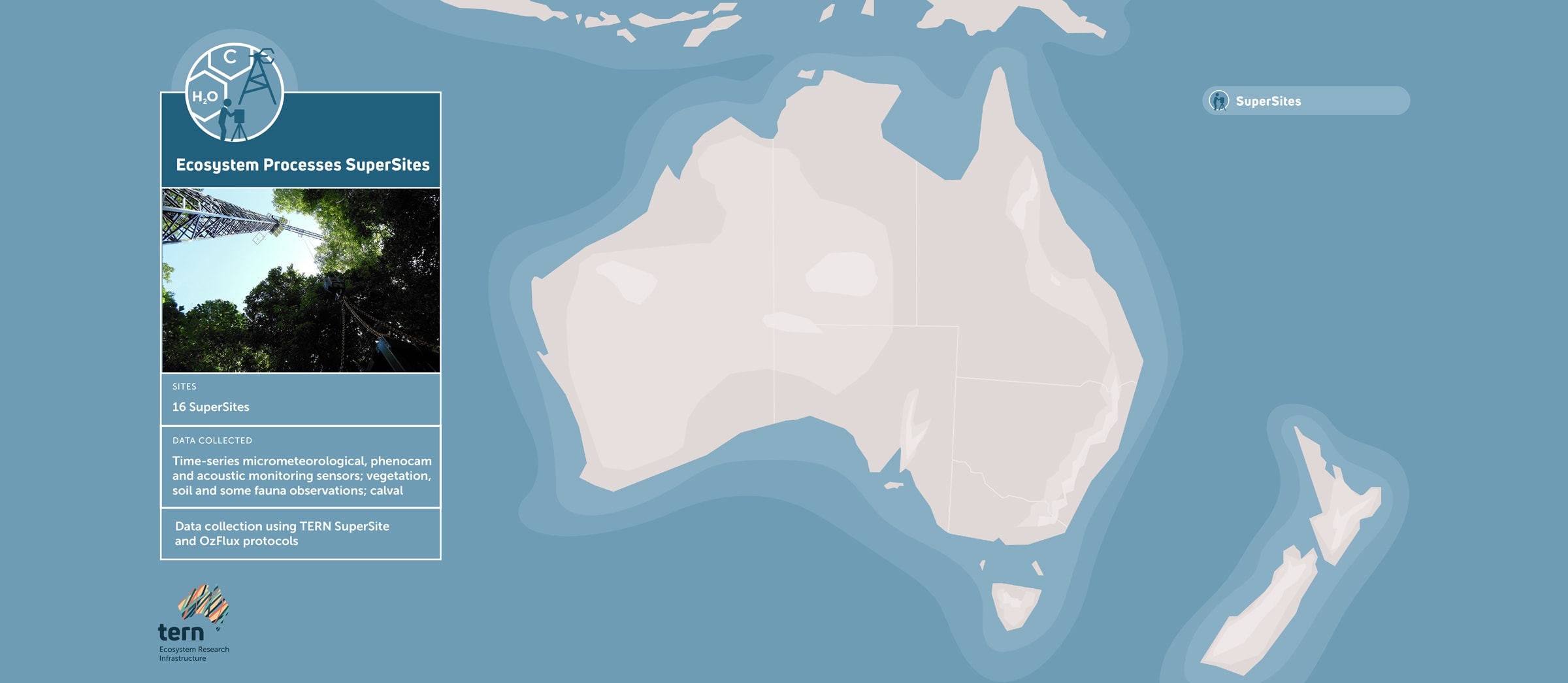
Whroo Dry Eucalypt SuperSite

4 km south-west of Shepparton, VIC on the lands of the Ngurai-illam-wurrung Aboriginal people.

Classified as box woodland, dominated by two main Eucalypt species (Eucalyptus microcarpa (Grey Box) and Eucalyptus leucoxylon (Yellow Gum)).   

14 of 16
Wombat Stringybark Eucalypt SuperSite

Located in the Wombat State Forest, near Ballarat, VIC.

Investigating the impacts of climate change and disturbances, such as fire and drought, on the dry sclerophyll eucalypt forests in southeast Australia.

15 of 16
NEW! Fletcherview Tropical Rangeland SuperSite

Located at James Cook University’s Fletcherview Research Station, two hours west of Townsville, Qld.

Open savanna woodland, dry rainforest, lava flows, three creek systems and the Burdekin River.

16 of 16

The new Fletcherview SuperSite is the newest addition to TERN’s network of 16 ecosystem process monitoring SuperSites 

Share Article