With TERN embarking on its next phase, we took the opportunity to recognise TERN’s work over the past five years. It was a challenge to succinctly list all TERN’s achievements, so we have indulged ourselves with an article that is much longer than our usual posts – the result not only catalogues key products and data but gives a sense of the overall work of each platform of TERN.
On this page:
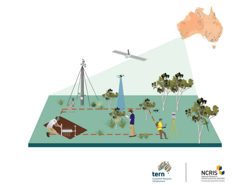
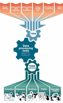
TERN provides world class research infrastructure to monitor and understand changes to our environment and climate and enable predictions of future risk.
Landscapes
Operating Partner – CSIRO
TERN Landscapes complements and completes the national land observatory with continent-wide, temporally dynamic information infrastructure. Drawing from other TERN Platforms (Surveillance, Processes and Data Services) and with connections across relevant R&D providers, Landscapes provides the scaling component of the TERN Observatory across space and time.
During phase II of Landscapes, it and its partners at UTas, UAdel, USyd, UNSW, DES, DEA, CSIRO, JCU, maitec and UTS have developed and delivered multiple high impact data products.
- A second version (V2) of the Soil and landscape Grid of Australia, expanding its scope and range as well as improvements and updates to V1 products
- A soil infrared spectral library and soil spectral inference capability based on TERN Surveillance soil specimens
- Daily Continental scale volumetric soil moisture
- High resolution, national scale Actual Evapo-Transpiration
- Cosmic Ray Soil Moisture Network
- Terrestrial Lidar scans to support Solar Induced Fluorescence product development
- Federation of national soils information
- Development of One TERN protocols for the collection of UAV/Drone data
- Support for TERN representation in the development of nationally consistent fire mapping products
- Support for the development of key chapters in the latest State of the Environment Report
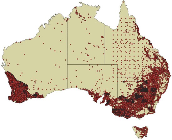
1. CosmOz Network
Over the last 5 years of TERN funding the cosmic-ray soil moisture monitoring network (CosmOz) has continued to deliver a highly valuable data set to natural resource management and researcher communities. Significant advancement in data processing and corrections have been made and the body of research using CosmOz data to validate and test model and satellite soil moisture estimates continues to grow. The following sections outline the key outcomes from the last 5 years.
a. Method development
A major advancement in the cosmic-ray neutron soil moisture data processing has resulted from the development of a new method for incoming neutron flux corrections. The corrections can be applied to cosmic-ray soil and snow sensors using data from the global neutron monitor network. This method was developed as part of improvements to data processing in the CosmOz network with a collaborator from the USA. The work has been recently peer reviewed and published and it is highly likely that all users of the cosmic-ray neutron moisture sensors will eventually use this approach in data processing due to the ease of application and proven robustness of the technique. This technique is major step forward in standardisation of processing methods around the world.
The international cosmic ray sensor network, Global COSMOS, which aims to harmonise data processing, is looking at adopting TERN’s method for incoming neutron flux corrections approach as standard practice.
The paper can be found here: https://doi.org/10.1029/2022WR033889
b. Satellite soil moisture validation
The CosmOz network has been used extensively over recent years for satellite soil moisture validation because of the temporal extent of data and spatial footprint of measurements.
Some examples of the use in satellite validation include:
- Researchers at the Bureau of Meteorology and the Space research Centre, RMIT undertaking drought monitoring over Australia and the South West Pacific using CosmOz data to validate satellite observations: https://doi.org/10.3390/rs14163971
- Researchers at Forschungszentrum Jülich GmbH, University of Arizona, Monash University, Wallingford and the Indian institute of Science using CosmOz data to validate and test 5 different satellite soil moisture products across different continents: https://doi.org/10.3390/rs9020103
- Researchers at CSIRO, University of Edinburgh and University of California used CosmOz data to assess the validity of satellite soil moisture estimates over parts of eastern Australia: https://doi.org/10.1016/j.atmosenv.2019.04.038
- Researchers at Monash University and CSIRO using CosmOz data to test multiple satellite soil moisture estimates in western Victoria: https://doi.org/10.1109/IGARSS.2018.8518208
c. Water balance and growth model validation
The CosmOz network data is also being used by a number of different research projects for validating water balance, carbon flux and growth models.
Some examples of this include:
- Researchers from the College of Water Conservancy and Hydropower Engineering, China and CSIRO using CosmOz data to calibrate water balance and growth models which are used to model Eucalypt forest sites across Australia. https://doi.org/10.2166/wcc.2021.374
- Researchers from University of Bristol, Columbia University, CSIRO, University San Paulo, and Helmholtz UFZ developing machine learning techniques which utilise cosmic ray data (including CosmOz sources) to better quantify water and carbon fluxes: https://doi.org/10.5194/egusphere-egu23-12444
- Researchers at ANU using CosmOz data to test downscale predictions from the Australian Water Resource Assessment Landscape model (AWRA-L) https://www.mssanz.org.au/modsim2021/papers/J10/yu.pdf
- Researchers from Melbourne University using CosmOz data to show how new continental scale soil datasets can be used to improve soil moisture predictions: https://doi.org/10.1016/j.jhydrol.2018.04.040
- Researchers from Sungkyun University and Cleveland State University using CosmOz data to test predictions from multiple soil moisture products across Australia https://doi.org/10.1016/j.jaridenv.2019.04.007
- Researchers at ANU using CosmOz network data in a data assimilation approach to improve continental water balance predictions DOI: 1002/essoar.10503460.1
d. Fire risk prediction
There has also been an increase in the use of CosmOz network data in the field of live fuel moisture content which is a vital information for fire fighting agencies. Examples of this work include:
- Researchers at Bureau of Meteorology and ANU developing a continental scale prediction system for live fire moisture content based on proven relationships with soil moisture estimates and using CosmOz data to test these relationships: https://doi.org/10.1016/j.agrformet.2021.108503
- The Bushfire and Natural Hazards CRC developing a new land surface modelling system called the Joint UK Land Environment Simulator based Australian Soil Moisture Information (JASMIN). JASMIN provides fire agencies with vital moisture indexes and fuel loads across Australia and has been validated using CosmOz data: https://www.bnhcrc.com.au/sites/default/files/managed/downloads/improving_land_dryness_ measures_final_report_feb-2021.pdf
- Researchers at ANU using CosmOz data to test soil moisture estimates which underly nation-wide estimates of the McArthur Forest Fire Danger Index: https://doi.org/10.1071/WF16217
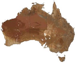
2. CMRSET v2.1 actual evapotranspiration (AET) dataset
Actual evapotranspiration (AET) is the water removed from the land by evaporation and transpiration. Accurate AET information is vital for informed water and environmental research, decision-making and resource management. The TERN AET dataset has been produced using the CMRSET (CSIRO MODIS ReScaled EvapoTranspiration) algorithm, which uses satellite-derived indices of reflectance to estimate AET from potential evapotranspiration (PET). The CMRSET AET model has been calibrated using data collected from the TERN OzFlux network. Remote sensing data from multiple sources were used to model AET so that the output is high-resolution (30m), high-frequency (monthly), continuous (no gaps due to cloud) and accurate—all ideal characteristics when calculating the water balance for a wetland, paddock, river reach, irrigation area, landscape or catchment.
From 1 July 2022 until April 2023 46 unique users have downloaded AET data from data.tern.org.au. The data are also available from the Google Earth Engine Catalogue.
https://portal.tern.org.au/metadata/21915
Guerschman, J.P., McVicar, T.R., Vleeshouwer, J., Van Niel, T.G., Peña-Arancibia, J.L. and Chen, Y. (2022) Estimating actual evapotranspiration at field-to-continent scales by calibrating the CMRSET algorithm with MODIS, VIIRS, Landsat and Sentinel-2 data. Journal of Hydrology. 605, 127318, doi:10.1016/j.jhydrol.2021.127318
Use by state agencies for water balance and groundwater assessment
- Western Australia’s Department of Water and Environmental Regulation (DWER) is currently using CMRSET v2.1 to assess the water use of the Dandaragan Plain, WA
Regional Irrigation water use assessment
- Researchers from the University of Newcastle, assessed regional water use of irrigation areas in the Murray-Darling Basin with CMRSET v2.1: https://doi.org/10.1016/j.jhydrol.2022.127650
Used to model groundwater
- Researchers from CSIRO used CMRSET v2.1 to partition transmission losses and groundwater use: https://doi.org/10.1002/eco.2490
Used to model groundwater dependent ecosystems
- Researchers from University of South Australia, CSIRO and Flinders University used CMRSET v2.1 to map groundwater dependent ecosystems: https://doi.org/10.1080/17538947.2023.2176557
Used to model tree plantation water use
- Researchers from the University of Western Australia, CSIRO, and Monash University used CMRSET v2.1 to constrain groundwater models at silviculture sites: https://doi.org/10.3389/frwa.2022.932641
- Researchers from CSIRO and University of Melbourne used CMRSET 1 to train a model of tree plantation water use: https://doi.org/10.1002/hyp.14836
Irrigation Compliance
- NSW State Government, specifically Natural Resources Access Regulator, NSW Department of Planning and Environment, use TERN AET output, in a multiple lines-of-evidence approach, to help determine irrigator compliance with their water licences.
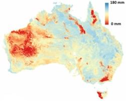
3. Continental Scale Daily Soil Moisture: SMIPS
Soil moisture is a critical driver in ecological function and landscape condition through water availability to plants within the unsaturated zone. Additionally, it is a key component in controlling how quickly runoff may occur in a particular landscape due to rainfall and is an important variable in managed landscapes for the initiation of planting, irrigation and application of fertilisers such as nitrates. Traditionally soil moisture is measured using point-based sensors either via electrical resistance or neutron absorption, and while these data are useful at a paddock scale, the ability to interpolate to larger areas is limited.
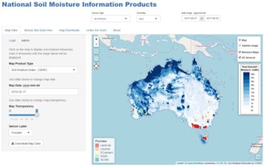
Typically, to estimate soil moisture over large areas, for example continental scales, physically based modelling is required to upscale relevant point scale measurements, but modelling is often unable to adequately capture and represent all of the physical processes involved due to inadequate parameterisation and low-quality forcing data.
Recently satellite products that estimate soil moisture at a global scale have become available and while these products have a continental coverage, and often a daily timestep, their spatial resolution is too coarse for appropriately scaled management decisions, and importantly they fail to capture important local processes. The SMIPS soil moisture system developed through TERN, takes a data model fusion path to produce daily estimates of volumetric soil moisture by combining the local physical representation of modelling with the spatial coverage in terms of national digital soil information and the temporal consistency of satellite-based products, to produce a “best-of-both-worlds” continental scale soil moisture product.
SMIPS data are being trialled in various uses such as crop models by groups such as Federation Uni, in catchment water balance models by JCU, in Koala modelling by NSW Department of Primary Industries and in Fire Prediction risk and modelling by various agencies and in irrigation compliance modelling by NSW Natural Resources Access Regulator.
From 1 July 2022 until April 2023, 25 unique users have downloaded SMIPS data from data.tern.org.au.
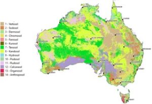
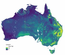
4. Soil and landscape grid of Australia V2: SLGA
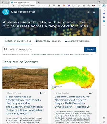
From 1 July 2022 until April 2023, 81 unique users have downloaded SLGA data from data.tern.org.au. The bulk of the downloads are still from CSIRO DAP where it is the most downloaded product with over 1.3 million downloads of a total of 170 Terabytes of soils data.
a. TERN SLGA Web API
The information generated from the Soil and Landscape Grid of Australia (SLGA) is commonly delivered as raster grids, where users download the whole or part of the raster and use a GIS to analyse and explore the data sets. But the SLGA also has a web API from which people can query SLGA soil information for any given pixel in the rasters.
By supplying the Latitude and Longitude in a web query (https://www.asris.csiro.au/ASRISApi/api/SLGA/simple/Drill?longitude=147&latitude=- 29.5&layers=ALL&kernal=0&json=false) users can access all SLGA soil the information for all raster products at that specific location. As well as supplying raw values for a given pixel, the API also has endpoints that deliver soil information in formats used by some widely used modelling platforms such as APSIM, HowLeaky and GrassGro.
These API endpoints have been accessed by users on 1,022,986 occasions to access soil information across all of Australia.
b. SoilWaterApp
Profitable and sustainable farming is an increasingly complex task. To remain as productive and efficient as possible Australian farmers need to make hundreds of decisions every year about their production systems. Understanding the condition of their soils, especially soil water content, at any point in time is a critical component in many key decisions. To assist with farmers knowing the soil water status of their soils at any point in time, GRDC and & the University of Southern QLD developed the SoilWaterApp.
However, to use the APP, there is a requirement to understand the properties of the soil at the designated location. Users can select a soil from a defined set within the App, but selecting a soil is a very complex task and one that users get wrong more often than not. To make this task easier, TERN Landscapes has collaborated with the GRDC and & the University of Southern QLD to incorporate a web API endpoint into the app which automatically generates a soil for a given location, thus reducing the soil selection headache for users.
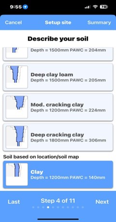
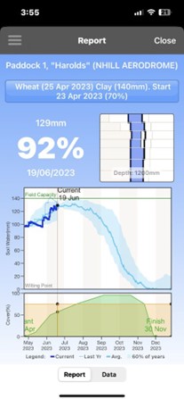
To date, SoilWaterApp users have used the TERN SLGA web API to automatically generate a soil for them 10, 897 times.
c. APSIM
Delivering food security to a growing global population (perhaps 9.2b by 2050) within environmental limits will require a comprehensive global response combining productivity increases, maintaining and improving the productive capacity of the resource base (Keating et al., 2014). Biophysical modelling is an essential tool in helping us understand and explore the likely magnitude of current and future food production potential and the likely implications of future demands on the soil resource.
The Agricultural Production Systems sIMulator (APSIM) (Holzworth et al., 2014) is internationally recognised as a highly advanced platform for modelling and simulation of agricultural systems. It contains a suite of modules that enable the simulation of systems for a diverse range of plant, animal, soil, climate and management interactions. It is used widely by researchers and agricultural practitioners around the world to analyse and understand crop productivity and investigate future potential cropping systems.
As with any cropping system model platform, correctly parameterising the soil properties in the model is critical to its correct performance, but can be exceptionally difficult to do, especially for users who are not soil specialists. Typically, an APSIM modeller would choose a set of soil parameters from a database of about 600 measured soil profiles across Australia. This is often a difficult and laborious task.
TERN has developed a Web API endpoint that generates an APSIM parameter file from the SLGA for any given location, greatly reducing the overheads of setting up APSIM simulations.
To date users have used the TERN SLGA web API to generate APSIM soil parameter files on 669,988 occasions to assist in performing critical agricultural research initiatives.
Just a few examples of scientific research utilising the SLGA for APSIM parameter generation include.
- Mapping future soil carbon change and its uncertainty in croplands using simple surrogates of a complex farming system model (paper)
- Integrating and using soil carbon stocks information from point to continental scale (paper)
- An estimate of carrying capacity of land for ruminant livestock production across southern Australia, using gridded batch simulation modelling (paper)
- Nitrate Uptake from an Aquifer by Two Plantation Forests: Plausibility Strengthened by Process-Based Modelling (paper)
- A reduced-tillering trait shows small but important yield gains in dryland wheat production (paper)
- Using GlobalSoilMap data for biophysical modelling – an Australian example (paper)
5. A System for Unifying Soil Observation Data – The SoilDataFederator
The problem
Australia is fortunate to have a large number of soil profile data observations and measurements publicly available for use in an ever-increasing range of applications. These data are collected and managed by a broad range of custodians across the country. These custodians collect the data for their own specific business purposes and manage it in a disparate range of data management environments. Until the development of the SoilDataFederator, every time a researcher wanted to access existing soil data sets in Australia, they have to approach the individual soil data custodians to obtain their data and then massage this data into a form that is suitable for their individual purposes. A challenging task rarely undertaken with any degree of excitement. This is a particularly inefficient means of implementing soil research and is often a barrier to innovation in soil science.
The first version of the Soil and Landscape Grid of Australia (SLGA) was produced in 2014. To create the SLGA, a national collation of all the readily available existing soil data had to be created. This process was complex and difficult and took roughly six months to compile observations and measurements from approximately 280, 000 soil profiles. One of the outcomes of this work was realisation that the Australian soil community needed a more efficient and effective way to access existing soil data.
The solution
At a conceptual level, there is a broad spectrum of approaches through which data unification can be achieved, from the creation of a centralised behemoth database through to the case-by-case collation of datasets. The “SoilDataFederator” is a federation approach to data unification, where data are managed by custodians but are federated on the fly into a consistent form.
The SoilDataFederator is a web application programming Interface (API) implemented in the R programming language. The API is used to query data over the internet via a standardised set of URLs with standardised parameters. Data can be returned in a range of formats but always in a standard form optimised for delivering data on a per attribute basis. The SoilDataFederator consists of a catalogue of available datasets and a series of associated “backend” modules which query the individual data systems and transform the data on the fly to the standard form.
The SoilDataFederator allows users to access soils data stores across Australia in a consistent manner and the data returned is a consistent format (figure 1). Users do not need to know the details of each of the individual data stores structures and querying mechanisms. The data in the system are historical soil survey data and are composed of both soil morphological description data and laboratory analysis data.
To obtain soil data, the user sends off a data request to the SoilDataFederator in a standardised form. The SoilDataFederator then transforms this query to the native query form required by each of the disparate data providers and queries the individual native datastores. The native data stores send back the data in their data individual formats to the SoilDataFederator which then transforms the individual data formats into a standardised response format which is then sent back to the user.
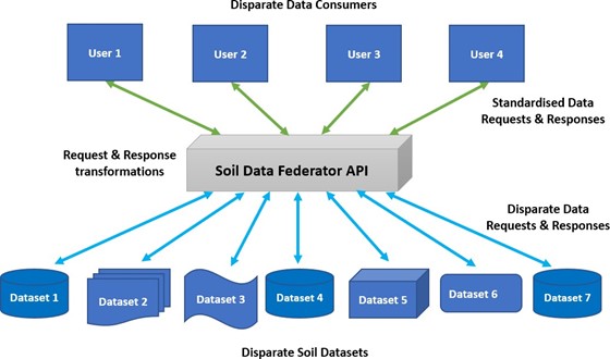
The SDF makes data available from a range of disparate “data providers”. A data provider is an individual or organisation that has one or more soils datasets that they would like to make available via the federated system. Most data accessible from the SDF are sourced from state and federal government soil survey agencies. These data are typically publicly available from each individual agency, but the means of accessing these data are many and varied. A key philosophy of the federation approach is to make it as easy as possible for data providers to make data available. Data providers are encouraged to provide data by the method, and in the format that is easiest for them to supply, thus reducing barriers to contributing data. The work of reformatting and standardising data is done by SoilDataFederator. Currently there are 14 data providers contributing data to the SDF.
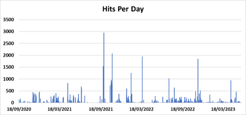
The SoilDataFederator has been in operation for approximately 2.5 years. In that time it has delivered 408 million individual soil data values to researchers. Times for compiling a national soil attribute datasets have come down from approximately 6 months to approximately 6 minutes.
The impacts
There are 94 individual users from 56 different organisations currently using the system. There is a diverse range of users of the SoilDataFederator, including CSIRO, Department of Environment and Science, Australian Red Cross Lifeblood, Federation University, Sydney Uni, CarbonLink, Carboncount, Treasury Wine Estates, The Mullion Group, NTT Global, Project Strategy, Deepplanet.ai and GHD to name but a few. Many of these are organisations that would not previously been able to access soil data.
Organisation Type | Number |
Companies | 22 |
Universities | 21 |
State Government | 9 |
Federal Government | 4 |
As well as greatly improving the efficiency of access to data the SDF, it is also significantly improving the relative cost of collecting soil data. We estimate that if the existing soil data of approximately 280, 000 soil profiles were only ever accessed for their original collection purpose, the cost of each soil data element per use is approximately $ 5.64. With the additional access to the data and use now coming from SoilDataFederator users we estimate the cost of each soil data element per use has fallen to approximately $ 0.42.
Currently the SoilDataFederator has enabled research on 9 published pieces of scientific work – https://scholar.google.com/scholar?hl=en&as_sdt=0%2C5&q=soilDataFederator&btnG=
The SoilDataFederator has enabled the development of a broad range of new soil information products including version 2 of the SLGA.
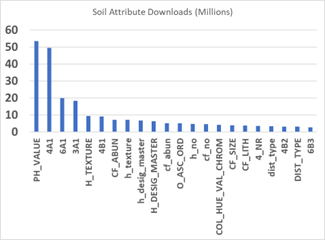
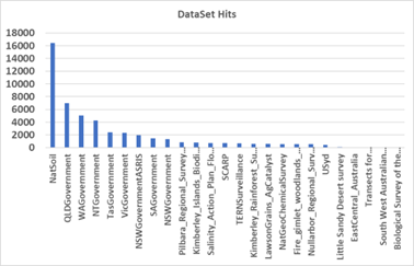
The SoilDataFederator is seeing continuous use by a range of users. The full listing of usage statistics can be found here, and a set of summary charts follows.
Relevant resources
Home page: https://esoil.io/TERNLandscapes/Public/Pages/SoilDataFederator/SoilDataFederator.html
API Help Page: https://esoil.io/TERNLandscapes/Public/Pages/SoilDataFederator/SoilDataFederatorHelp.html
API Swagger Docs: https://esoil.io/TERNLandscapes/SoilDataFederatoR/ docs /
Register to use the API: https://shiny.esoil.io/SoilDataFederator/Pages/Register/
Usage Statistics: https://shiny.esoil.io/Apps/SDFStats/
Ecosystem Surveillance
Operating partner: University of Adelaide
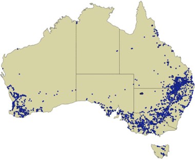
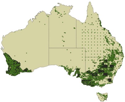
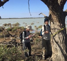
TERN’s plot-based regional ecosystem monitoring program formed in 2019 from the merger of the former AusPlots and Australian Transect Network. It has now established almost 1000 1 hectare reference plots and conducts standardised ecological surveys across all Australian ecosystem types, delivering long-term data on the nation’s vegetation and soil.
Some of the highlights of the past 5 years of the program include launching the TERN Australia Soil and Herbarium Collection, development and delivery of derived data products that enable researchers to easily use TERN data and samples, and extensive researcher and industry engagement for enhanced impact.
TERN’s Ecosystem Surveillance program conducts field surveys and sampling across a national network of plots and transects to provide the environmental monitoring data, samples, advice and terrestrial ecosystem mapping needed for improved monitoring and assessment of Australia’s major ecosystems. The data and tools from the program help scientists and land managers better detect and quantify change in vegetation structure and composition, land cover and soil characteristics.
The TERN ausplotsR package provides direct access to field data collected at TERN’s network of monitoring plots.
Data access through ausplotsR is currently averaging more than 500 downloads per month, over 1,200 clients have been served with data extractions, summing to ~4 billion data records for in excess of 130,000 individual data requests.
To continue to meet the requirements of the research community, the resource is constantly being refined and updated. For example, the latest functionality in ausplotsR includes improved taxonomic standardisation, and easier handling of revisits (repeat surveys at TERN plots) thanks to R-readable date field and revisit numbers appended to each survey. Enhanced search options include visits and partial site matches, and a new function rapidly visualises change along a sequence of revisits.
Additionally, maps defining C3 and C4 plant cover for the entire Australian continent have been added along with the first harmonised dataset at the national scale, including introduction status for all vascular plants
The past 5 years have also seen the program develop powerful new methods combining modelling and field surveys to determine optimal monitoring locations in under-represented bioregions.
Monitoring sites established since 2019 now fill these previous gaps and deliver better spatial and temporal data to meet the needs of researchers and modellers.
Research and industry support
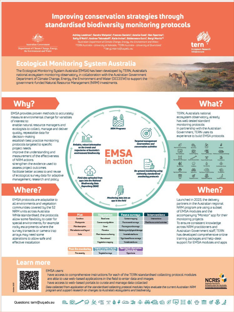
In collaboration with the Australian Government, TERN has developed innovative solutions to monitor the effectiveness of billions of dollars spent on natural resource management in Australia. The resulting standardised ecological monitoring protocols (EMSA) and progressive web app will be widely implemented by NRM groups over the next 5 years enabling them to effectively monitor the impact of their on-ground works.
Surveillance has collaborated with experts and on-ground practitioners to define best practice in ecological monitoring and unified widely accepted protocols with next-generation technology solutions. This work was even recognised in the 2023 South Australian Environment Awards, where the TERN team was a finalist for the Innovation category.Sally O’Neill won the 2023 University of Adelaide Executive Dean of Science, Engineering and Technology Staff Award for Innovation for her work on EMSA.
TERN Ecosystem Surveillance has played an influential role in supporting a diversity of organisations across Australia and internationally, including universities, government, not-for-profit and community groups to accomplish impact in the fields of climate change research, biodiversity monitoring, taxonomy, and land management.
A selection of publications using TERN Adelaide research infrastructure includes Next-gen DNA sequencing for improved environmental impact assessments; monitoring the impacts of bushfires on soils, defining paper daisy taxonomy, mapping available phosphorous and development of a new threatened woodland recovery plan.
Additionally, the program’s citizen science projects on birds and orchids continue to define and test innovative techniques for community collaboration in national research infrastructure, with the goal of expanding the temporal and spatial coverage of our data collection.
Launching TERN Australia Soil and Herbarium Collection
The TERN Australia Soil and Herbarium Collection at the University of Adelaide’s Waite campus was launched in December 2022. The archive brings together more than 150,000 soil and plant samples collected over 10 years from almost 1000 sites across the country. The TERN collection is now officially recognised by the Index Herbariorum, a global network of herbaria. Construction of the facility was funded by NCRIS, the South Australian Government and the University of Adelaide.
Volunteers contribute significantly to TERN Ecosystem Surveillance fieldwork, data management and sample curation, and in return receive training and up-skilling translating to improved employability. In 2022 the platform was recognised by the University of Adelaide winning the University Volunteer Achievement, Group Award – Community.
TERN Ecosystem Surveillance Lead, Associate Professor Ben Sparrow, also received recognition under the 2021 University of Adelaide Award for Outstanding Achievement in the category of Culture of Impact and Excellence: Exceptional Leadership.
For more information
- https://www.tern.org.au/tern-land-observatory/ecosystem-surveillance-and- environmental-monitoring/
- https://www.tern.org.au/training-and-volunteering/
- https://www.tern.org.au/field-survey-apps-and-protocols/
- https://www.tern.org.au/field-sample-library/
Ecosystem Processes
Operating Partner: James Cook University
In 2019, this platform was formed when the former OzFlux and Australian SuperSites facilities were brought together under JCU.
The security of 5 year funding enabled remarkable progress in how Australia monitors its environment in a high level of detail at representative or ecologically important sites.
Here we highlight some of the key initiatives, collaborations, and achievements of TERN Ecosystem Processes platform that have paved the way for world class research and innovation.
TERN’s Ecosystem Processes platform manages 16 intensively monitored field stations which combine instrumented or sensor measurements with classical field surveys and remote sensing activities. The platform delivers:
- Micro-meteorological observations of atmospheric-ecosystem energy, carbon and water exchanges; and
- Biological and environmental observations of flora, fauna, microbial biodiversity, soils, and hydrology.
Over the 2018 to 2023 NCRIS-enabled funding period, notable infrastructure developments, integration and research enablement highlights from the platform include:
- Establishment of TERN Ecosystem Processes to operate the Australian SuperSites Network and OzFlux as an integrated platform.
- Development of near-real time monitoring of functionality for remote sensors and other research infrastructure across TERN investment and international co-investment has enabled several TERN field stations to be ranked amongst the world’s most vital for ensuring the accuracy of global earth observation programs and products.
- Development of autonomous data collection system for remote monitoring field stations across Australia.
- Establishment of a new monitoring field station (Fletcherview Tropical Rangeland SuperSite) and the strengthening of existing infrastructure (Samford Peri-Urban SuperSite) through Queensland Government co-investment in NCRIS-enabled TERN.
- Integration of a range of novel environmental sensors and biodiversity monitoring plots at field stations in Western Australia through state government co-investment in NCRIS- enabled TERN.
- Assisting newly established (via ARC LIEF funding or industry funding) ecosystem monitoring networks which develop monitoring protocols, data and sample collection and publication pipelines. These include the Australian Mountain Research Facility (AMRF), the Australian Critical Zone Observatories network (OzCZO) and QUT’s ‘data platform for increasing soil carbon in Australia agricultural systems’.
- Significant FAIR data publications including:
- Wet Tropics Vertebrate database – Biodiversity data collected over 30 years
- Alice Springs Mulga Flux Data
- Boyagin Flux Data
- Calperum Chowilla Flux Data
- Cumberland Plain Flux Data
- Cape Tribulation Flux Data
- Cow Bay Flux Data
- Fletcherview Tropical Rangeland Flux Data
- Gingin Flux Data
- Great Western Woodlands Flux Data
- Litchfield Flux Data
- Longreach Mitchell Grass Rangeland Flux Data
- Robson Creek Flux Data
- Samford Ecological Research Facility Flux Data
- Tumbarumba Flux Data
- Warra Flux Data
- Whroo Flux Data
- Wombat State Forest Flux Data
- Robson Creek Rainforest Acoustic Data Collection
- Samford Peri-Urban Ant Abundance Data
- Daintree Rainforest, Cape Tribulation Ancillary Images Collection
- Enabling the publication of 600 – 700 significant research publications using primary or derived data. View the TERN publications database here. Note – the publication range is provided because not everyone attributes TERN when they use its data and sites.
The TERN Ecosystem Processes platform has gradually increased its support of the ARC LIEF funded Critical Zone Observatories (OzCZO) infrastructure.
OzCZO infrastructure is currently being collocated at several TERN field stations— five sites altogether.
The Avon River CZO in Western Australia is closely associated with TERN’s Boyagin Wandoo Woodland SuperSite and a suite of monitoring infrastructure has been installed there. The Calperum Mallee SuperSite gained a CZO monitoring kit and groundwater bores in September 2023. The Fletcherview Tropical Rangeland SuperSite CZO sensors are due to be fitted after the 2023 wet season. The remaining two CZO sites (Petrie in south-east Queensland and Wellington in western NSW) are not TERN core sites per se at this point, but CZO infrastructure has been installed there with TERN support.
The critical zone is that zone, from groundwater or bedrock to the tops of the trees, which sustains all life on the planet. Thus, the infrastructure includes bores to get down to depth and flux towers to get up to height, for characterising the entire ecosystem. So, this infrastructure will further characterise the soil and hydrology of TERN sites, as well as the fluxes, adding a critical dimension to the future of TERN’s intensive local-scale monitoring.
The 5-year period also saw the impact of extreme weather on data continuity from field-based monitoring infrastructure. The Victorian Wombat site (University of Melbourne operated) and the Tasmanian Warra (University of Tasmania) flux towers were felled by falling branches in extreme winds. The Tumberumba SuperSite (formerly operating by CSIRO, now UQ) was destroyed by the 2019-20 fires of Australia and Litchfield (operated by Charles Darwin university) was hit by lightning, which led to fire damage. A combination of insurance money and a special grant from NCRIS for equipment resilience are available to replace equipment and restore sites but COVID, materials and labour shortages, and widespread floods have seen these sites out of commission for most of the grant term.
Further information
- Access all datasets collected by the Ecosystem Processes platform via TERN’s Data Discovery Portal
- Learn more about TERN’s Ecosystem Processes platform
TERN Data Services and Analytics (TDSA)
Operating Partner: University of Queensland
In 2018-2019, the TERN Data Services and Analytics (TDSA) platform was established as a new capability to bring a uniform data management practice across TERN and with the following specific objectives:
- develop an integrated approach to planning, designing, developing, and maintaining the TERN eInfrastructure;
- data publication under the FAIR (Findable, Accessible, Interoperable, Reusable) principle;
- development of new data streams made available due to the expansion of observation methods;
- harmonisation of heterogeneous data at different scales to derive national-scale data products; and
- harnessing data standards and interoperability in information management to offer a scalable platform for any synthesis activities.
In the 2019-2023 NCRIS grant period, TERN has come a long way in pursuit of becoming one of the leading data and information service providers to enable a better understanding of changes in Australia’s terrestrial ecosystem. Specifically, the TDSA built and managed eInfrastructure for effective data management of site-based ecological survey data,
time-series sensor observations and continental-scale gridded data products. The infrastructure’s key drivers have been to enable users to search, discover, visualise, and access data via APIs – the Application Programming Interface.
At the commencement of the 5-year period, TERN had to manage legacy facility-centric infrastructure while building the new cohesive infrastructure for better data management. TERN embarked on building scalable and cloud-native data infrastructure to meet all objectives. However, streamlined data management practices are essential to make data FAIR. Hence, TERN has adopted the following data management practices.
- A robust data governance with policies and procedures – all policy-related documents are available at https://tinyurl.com/7nd4exv2.
- A robust ontology-based information model to represent observation, sampling, and intervention activities as part of site surveys.
- The information model (see https://linkeddata.tern.org.au/viewers/tern-ontology) integrates data from multiple survey databases and makes them available at EcoPlots, the data integration platform for site-based survey datasets.
- Comprehensive controlled vocabularies to represent platforms, instruments, observable properties, and units of These vocabularies are used to annotate data to improve discovery and access.
- The SKOS-based vocabularies developed and utilised at TERN are available at https://linkeddata.tern.org.au/viewer/tern/.
- Application of the ISO 19115-3 metadata standard to describe all
- An ISO 19115-3 profile was developed to capture all contextual information required to meet business needs.
- The GeoNetwork catalogue manages all metadata developed and published at
- Publication of all longitudinal data as data products for easy access and
TERN has successfully migrated datasets from previous partner-operated Facility portals, including TERN Supersites, TERN ACEAS, TERN AusCover, and TERN OzFlux, into its new e-infrastructure. Additionally, following its decommission and in line with the 2016 National Research Infrastructure Roadmap, TERN has migrated the relevant Australian Coastal Ecosystem Facility (ACEF) records to IMOS. However, the migration of the TERN-University of Adelaide based AEKOS repository is still under progress.
Several datasets including TERN AusPlots, TERN AusPlots forest, and the Queensland Government vegetation database have been migrated to the new EcoPlots and by mapping source data to the TERN Ontology, vocabularies have been created for observable properties, feature types and attributes.
EcoPlots contains 1 billion data points and links to more than 1M images
To maintain higher standards in repository management and achieve international ranking, TERN has applied for CoreTrustSeal Certification of its repositories. The first round of the review process is already completed and TERN is currently working on resubmission. Reassessment occurs on a 3-year cycle.
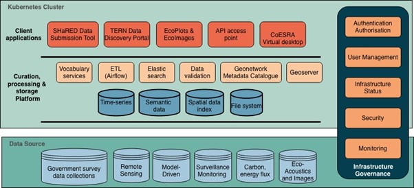
TERN Data Infrastructure
TERN uses the Australian Research Data Commons (ARDC) Cloud node, QRISCloud, operated by Queensland Cyber Infrastructure Facility (QCIF), to manage all its eInfrastructure. In addition, several ARDC core NeCTAR infrastructures are also utilised. A high-level overview of the infrastructure can be seen in Figure 1.
TERN Tools
The following are some of the applications built by TERN to interface with users to submit, access and analyse data collected and collated by TERN.
• SHaRED: Data Submission tool to submit ISO 19115-3 compliant dataset at TERN.
- The tool is used to submit metadata and data managed at
- All data submission to TERN happens through
- The application is accessible from https://shared.tern.org.au.
• TERN Data Discovery Portal: the gateway to search, discover and access all data published at TERN.
- The application is accessible from https://portal.tern.org.au/.
• Data Visualiser: TERN, in collaboration with ANU, has built a data visualiser.
- Most of the raster data collected at TERN and some of the time-series data are
- The application is accessible from https://maps.tern.org.au.
• EcoImages: The web application to search and access images collected during survey visits.
- Users can select multiple sites and image types to choose and download
- Each download will have a data package comprising images, related metadata, and citation details.
- The application is accessible from https://ecoimages.tern.org.au.
- Users can also download images through API
• EcoPlots: The data integration platform to access site-based survey data.
- The data complies with the standard information model (TERN Ontology) developed at TERN.
- The application is accessible from https://ecoplots.tern.org.au.
- TERN will add more features and datasets in the coming
• CoESRA: TERN has developed a cloud-based virtual desktop environment to create and share analysis pipelines.
- The desktop is accessible from a web browser and will provide both a CPU and GPU desktop flavour.
- The virtual desktop is accessible from https://coesra.tern.org.au/.
Collaborations
TERN has worked on collaborative projects with national and international research infrastructures and provides leadership roles in effectively managing the terrestrial ecosystem data components of the projects.
- EcoAssets: EcoAssets | Building Data Linkages for Environmental Reporting (ARDC funds)
- brings together environmental data collected from ALA, IMOS and TERN using standardised formats for the data resources then shares them in a manner that allows the information to be streamlined into integrated data assets to support Australia’s environmental reporting EcoAssets was successfully used and referenced by authors of the 2021 State of Environment Report.
- EcoCommons: World-first Collaborative Commons | EcoCommons (ARDC funds)
- EcoCommons is a platform for modelling and analysis and it now contains many of TERN’s data sets, such as those from the Surveillance platform, which, along with occurrence data from ALA, supports species distribution modelling.
- Australian Bushfire Data Commons: Bushfire Data Challenges Program | ARDC (ARDC funds)
- TERN has built a platform for aggregation and harmonisation of fuel data on a national scale. TERN has used its own curated and harmonised fuel data assets comprised of TERN plot data and aggregated data from DCCEEW and states as an initial product for demonstrating the ongoing capacity of the platform to share fuel data and related attributes from multiple sources to better enable Australia-wide bushfire preparedness and response.
- Australian Scalable Drone Cloud: Australian Scalable Drone Cloud (asdc.io) (ARDC funds)
- TERN has contributed tools and expertise to allow ingestion of data into this scalable open source platform for data processing, analysis, visualisation & publication for drone users.
- GeoPhysics 2030: 2030 Geophysics Collections | ARDC (ARDC funds)
- The aim of this project was to make national high-resolution geophysics reference collections suitable for exascale computing in 2030. A Jupyter notebook was built that combines TERN flux data with NCI Aster data to produce a useful tutorial https://nbviewer.org/github/NCI-data-analysis- platform/geophysics/blob/main/geophysics_2030_UATs/ASTER_OzFlux_Horizontal_ ipynb.
- This type of integration of aster and observational point located data sets to enhance direct calibration of the satellite/airborne captured data will become even more important as the resolution and size of the hyperspectral datasets continues.
- Open Ecoacoustics: Home | Open Ecoacoustics (ARDC funds)
- TERN contributed expertise to the building of a dedicated ecoacoustics platform that is open to everyone and interfaces with TERN’s data depository so that users can aggregate and share data, analyses and tools.
- AusEnHealth: AusEnHealth (Frontiers SI)
- TERN provided expertise to the building of a pilot knowledge resource to understand the landscape of Australian environmental health data collection at both state and national levels.
- GeoNadir drone data: GeoNadir | Drone Mapping Software For Research (Qld Hub of CRC SmartSat)
- This project allowed a TERN secondment to GeoNadir to develop a connection between GeoNadir and the TERN Data Discovery to make TERN drone related data discoverable from GeoNadir repository.
- DCCEEW Data Exchange Standards: TERN develops new ecological survey data exchange standard | TERN Australia (Australian Government)
- TERN was contracted to develop a data exchange standard for the Government’s Biodiversity Data Repository. TERN’s information model systematically and consistently describes field survey observations and represents the concepts related to ecology surveys, their properties, relationships, and constraints.
- The information model provides a framework to exchange any ecological survey data to improve semantic and syntactic interoperability.
Internationally, TERN’s Dr Guru chaired the Information Management Committee of the International Long Term Research network, helping to steer the group of over 40 country members towards standardised cross-national systems for managing long term data.
Dr Guru was co-chair of the working group that has developed ABIS, the Australian Biodiversity Information Standard – see Australian Biodiversity Information Standard | abis (ausbigg.github.io). ABIS is an integral part of the Biodiversity Data Repository (BDR) project for the Department of Climate Change, Energy, the Environment and Water.
TERN HQ
Partner organisation: University of Queensland
Some of the highlights from 2018-2023
- We were granted and administered $36.3M in NCRIS funding for the period. We also obtained confirmed baseline funding to 2028 of $36.7M and an additional $28M over 2023-27 to undertake a number of step change activities.
- The Threatened Species Index transferred to TERN HQ management in 2021 after the NESP ‘Threatened Species Recovery Hub’ closed.
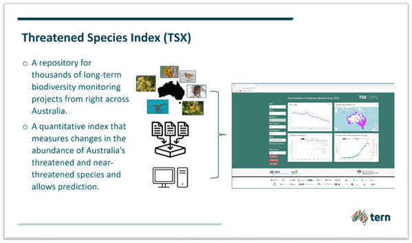
TERN adopted the Index in recognition of the national value of the time series data, which helps to answer one of TERN’s scientific questions related to the effectiveness of ecosystem management programs. Co-funding from DCCEEW to employ dedicated staff made the transfer feasible and TERN has continued to develop the functionality of the Index and release further trend reports.
Impact of the Index has been shown in many ways, particularly inclusion within the 2021 State of Environment Report of bird, mammal and plant trend data from the Index. Also, using TERN data accessed on 28/06/2023, the Australian Treasury chose as its metric for Australian biological diversity the trend data produced by the Index. The Treasury Report is called “Measuring What Matters”, and it is Australia’s first national wellbeing framework that tracks our progress towards a more healthy, secure, sustainable, cohesive and prosperous Australia. The ‘Measuring What Matters’ Framework has 5 wellbeing themes and under the Sustainability theme, it defined its metric as “Proportion of decline in Australia’s threatened and near threatened species from the “Threatened Species Index”. It was concluded that Australia’s threatened and near threatened species populations are continuing to decline at an average rate of 55% in relative abundance in 2019 compared to the 1985 baseline for the 278 species represented.
3. Production of Australia’s Environment Report was brought fully into TERN from ANU in 2019. Each year since 2015, the report has provided a summary of key environmental indicators and how they changed in the preceding year. TERN produced it at 6 monthly intervals after the 2019-2020 bushfires.
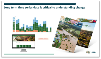
The report allows patterns of change in Australia’s ecosystems to be assessed at postcode, electorate, state and national levels with printable report cards customised to the user. Australia’s Environment complements Aust. Govt. State of the Environment reporting, allowing researchers and managers to monitor and analyse trends in the years between.
4. TERN commenced a Biennial Science Symposium series in 2021, the first being virtual due to COVID travel restrictions. The hybrid 2023 Symposium attracted 450 registrations, including 6 in-person from Asian countries. The Symposia are promoted as a forum for sharing both transdisciplinary and traditional approaches to ecosystem science research, technological development, data system innovation, collaboration and action. With industry, government and researcher attendees, the Symposium is succeeding as a forum at which any of the community can present how they are using TERN.
5. To mark its 10th anniversary in 2019, TERN celebrated with the publication of a book (‘Observing Environmental Change’) that recognised the achievements of the ecosystem research community that had helped design, build and operate TERN since the first grant contract was signed in May 2009.
6. Later, in 2022, TERN celebrated the launch of the TERN Australian Soil and Herbarium Collection facility with publication of a book that recognised the work of 33 Australian soil scientists in Australia whose research over the decades has helped lay the foundations to the world leading Australian soil science that is carried out now with the aid of TERN data.
7. TERN’s international reputation continued to grow. With at least 2,300 publications having cited TERN data and/or mentioned use of its sites, TERN has evidence of its growing international impact. Note – if researchers fail to provide attribution to TERN, it is difficult to track impact through publications.
8. Following on from a workshop called “Towards a global ecosystem observatory” which TERN instigated in 2016 in Brisbane with attendees from other continental- scale ecosystem observatories, in 2019, a federation of 6 observatories were recognised under the principles of the Group of Senior Officials as the Global Ecosystem Research Infrastructure (GERI) and an MOU was signed. One of the first achievements of GERI was identification and mapping of all the data types from each of its members.
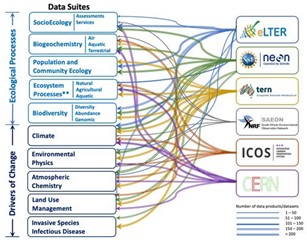
The data are grouped according to drivers of changes (causes) and the ecological processes (effects). The data are then visualised into broad (searchable) respective common ecological categories. The GERI members were successful in obtaining a significant National Science Foundation “Accelnet” grant in 2023 to have researchers use data from its members to study ecological drought on a global basis. TERN participated in preparing the grant.
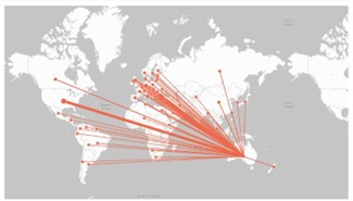
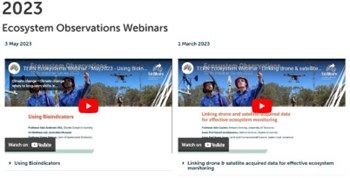
9. TERN’s international status is reinforced through consistent attendances at its TERN biomonthly webinars where registrants have come from up to 40 countries and with total number of registrants averaging around 200 but sometimes greater than 600. With each webinar recorded and uploaded to the TERN website, we are aware that they have been adopted into some university courses as required viewing.
10. In 2021, TERN was represented at COP26 in Glasgow as part of a poster presentation on its contributions via GERI’s collective data, services and information about the function and change of indicator ecosystems across biomes and to the FLUXNET’s data on land fluxes of Green House Gases (GHG), which places TERN’s OzFlux monitoring stations on a global map. The presentation made a case for land flux data to be recognised as an essential climate variable.
11. With travel to TERN SuperSites by researchers generally extremely difficult logistically and cost-wise, TERN commenced making catalogue of virtual tours. TERN, IMOS and AuScope, unlike most other NCRIS- funded research infrastructures, carry out observations and monitoring on behalf of researchers and generally engage with researchers through their data collections.
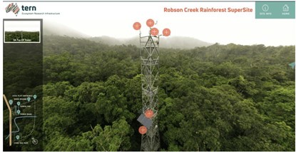
However, there is growing interest around the world in knowing where the data comes from and even co-locating research equipment at sites for individual long term research (see Ecosystem Processes report for instance with respect to researcher use of Litchfield and Fletcherview sites). The virtual tours are designed to help people understand what each site looks like and what sensors are already on location. Three sites were completed in this funding round (two already published and one awaiting finalisation) and more are planned for 2023-28.
12. As part of its engagement strategy, TERN established collaborations with several not-for-profits, for example, Bush Heritage, AWC, Birdlife Australia and Earthwatch, some of which have been formalised with an MOU or data sharing agreement. The benefits range from collaborating with respect to location of monitoring sites, sharing data and Citizen Science actitivities.
For example, each year, Earthwatch runs its Student Challenge at Calperum Station where teams from corporate, student and teacher backgrounds partake in research focused on carbon, water and biodiversity responses to the changing land. The Calperum SuperSite is hosted on a reclaimed cattle station run by the Australian Landscape Trust. TERN was also successful in being awarded a Qld Government “Engaging Science” grant to bring general public, higher education students and other stakeholders to its Samford periurban SuperSite, hosted by the Queensland University of Technology (QUT).